Dilley, Oregon
| Dilley, Oregon | |
|---|---|
| Unincorporated community | |
|
Home and barn in Dilley | |
 Dilley, Oregon  Dilley, Oregon Location within the state of Oregon | |
| Coordinates: 45°29′26″N 123°07′35″W / 45.49056°N 123.12639°WCoordinates: 45°29′26″N 123°07′35″W / 45.49056°N 123.12639°W | |
| Country | United States |
| State | Oregon |
| County | Washington |
| Elevation | 197 ft (60 m) |
| Population (2000 est.) | |
| • Total | 2,000 |
| Time zone | Pacific (PST) (UTC-8) |
| • Summer (DST) | PDT (UTC-7) |
| ZIP code | 97116 |
| Area code(s) | 503 and 971 |
| GNIS feature ID | 1166645[1] |

Dilley is an unincorporated community in Washington County, Oregon, United States. It is located south of Forest Grove and north of the city of Gaston on Oregon Route 47 in the Portland metropolitan area. Settled in the late 1840s, the community was platted in 1874 after the arrival of the railroad. The population of the area in 2000 was approximately 2,000.
History
Horace and Marilda Parsons settled in the area located south of Forest Grove in 1849.[2] In 1850, Parsons built a grist mill along the Tualatin River near what later became Dilley on the land claim of William Owen Gibson.[2][3] Gibson settled his claim in 1847, and built the log cabin used for Tabitha Brown’s orphan school that later became Pacific University. Dilley School District 10 was established in 1860, with a school built on the north end of the town that same year.[3] A flour mill was added nearby in 1863, and Joseph Gaston’s West Side Railroad reached the area in 1872.[3] James C. Chamberlain, was the first postmaster of the post office established on December 31, 1873.[3]
On March 18, 1874, Milton E. and Martha Dilley platted the area that became Dilley Station.[3] They created the town on the Donation Land Claim of the Chatfield family.[3] The Dilleys arrived in 1853, with Milton buying 140 acres (0.57 km2) in the area.[4] The original plat had east-west running streets of A through D and north-south running streets of First through Fourth.[3] There were 13 lots along the roads that varied from 30 feet (9.1 m) wide to 60 feet (18 m) wide.[3] Other businesses in the community in the early years were a barber shop, general stores, ice warehouse, and a blacksmith among others.[3]
In 1880, Mr. McLeod and two sons built a sawmill in the area.[3] In 1895, 23 years after the railroad reached the area, a station was built in Dilley.[3] The Methodist Church in town was established in 1896, and around 1953 the Bible Church of Dilley was started.[3] Other businesses at one time included a hotel, dance hall, saloons, machine shop, and a hardware store.[4] About 1961 the Dilley post office was closed.[5] At one time the town had a band and baseball team.[4] In 1967, the last store and gas station were torn down when Oregon Route 47 was re-routed.[4] By 1976 the school was consolidated into the Forest Grove School District. In 1998, the community made national news when a convicted sex offender was scheduled to live in the community at his mother's home.[6][7] Neighbors objected, and purchased the home to prevent the offender from moving to Dilley.[6][7]
Details

Dilley Elementary School, part of the Forest Grove School District,[4] received a rating of exceptional by the state for the first six years of the state rankings.[8] The community has one church, Bible Church of Dilley. Dilley is part of the Forest Grove Rural Fire Protection District.[9] Oregon House of Representatives District 26 (Matt Wingard) and Oregon Senate District 13 (Larry George) cover the community.[10][11] Dilley is within Oregon's 1st congressional district, represented in Congress by Suzanne Bonamici.[12]
As of 2000, the estimated population of the area was as high as 2000 people, though there are no defined boundaries for the community.[1][4] The community has the Forest Grove ZIP Code of 97116, and area codes 503 and 971.[13] The main roads in the area include Oregon Route 47 (also known as Tualatin Valley Highway) that runs north-south, along with southwest Anderson and Dilley roads. Dilley, classified as a populated place, sits at an elevation of 197 feet (60 m) above sea level.[1] The U.S. Geologic Survey operates a water gauge on the Tualatin River at Dilley.[14]
References
- 1 2 3 "Dilley". Geographic Names Information System. United States Geological Survey. 1980-11-28. Retrieved 2009-05-29.
- 1 2 Mandel, Michelle (January 5, 2006). "Metro West Neighbors: Proven pioneers". The Oregonian. p. 1.
- 1 2 3 4 5 6 7 8 9 10 11 12 Bamford, Lawrence (October 19, 1976). "Communities: Dilley Station featured depot, grist mill on Tualatin River". Hillsboro Argus. p. 12.
- 1 2 3 4 5 6 Mandel, Michelle (January 20, 2000). "West Zoner: A Dilley of a place". The Oregonian. p. 1.
- ↑ "Business and Industry: Post offices, zip codes listed". Hillsboro Argus. October 19, 1976. p. 11.
- 1 2 Daza, Rosario (August 18, 1998). "Dilley sex predator case draws wide scrutiny". The Oregonian. p. B1.
- 1 2 Daza, Rosario (August 7, 1998). "Dilley pungles up to protect children". The Oregonian. pp. D1.
- ↑ Tareen, Sophia (December 16, 2004). "West Zoner: There's a reason Dilley's on top". The Oregonian. p. 1.
- ↑ "County Bridges & Fire District Boundaries." (PDF). Washington County. Retrieved June 23, 2014.
- ↑ Pitz, Ray. “Wingard hangs onto House seat,” The Forest Grove News-Times, November 7, 2008. Retrieved November 17, 2012.
- ↑ "Senate District 13." (PDF). Oregon Secretary of State. Retrieved March 9, 2009.
- ↑ "Representative in Congress". Oregon Secretary of State. Retrieved March 1, 2012.
- ↑ "Churches.". City of Forest Grove. Retrieved May 29, 2009.
- ↑ "USGS 14203500 Tualatin River near Dilley, OR.". U.S. Geologic Survey. Retrieved May 29, 2009.
External links
![]() Media related to Dilley, Oregon at Wikimedia Commons
Media related to Dilley, Oregon at Wikimedia Commons
Municipalities and communities of Washington County, Oregon, United States | ||
|---|---|---|
| Cities | 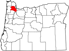 | |
| CDPs | ||
| Unincorporated communities |
| |
| Ghost towns | ||
| Footnotes | ‡This populated place also has portions in an adjacent county or counties | |