Schlüchtern
| Schlüchtern | ||
|---|---|---|
| ||
 Schlüchtern | ||
Location of Schlüchtern within Main-Kinzig-Kreis district  | ||
| Coordinates: 50°21′N 09°31′E / 50.350°N 9.517°ECoordinates: 50°21′N 09°31′E / 50.350°N 9.517°E | ||
| Country | Germany | |
| State | Hesse | |
| Admin. region | Darmstadt | |
| District | Main-Kinzig-Kreis | |
| Government | ||
| • Mayor | Falko Fritzsch (SPD) | |
| Area | ||
| • Total | 113.30 km2 (43.75 sq mi) | |
| Population (2015-12-31)[1] | ||
| • Total | 15,827 | |
| • Density | 140/km2 (360/sq mi) | |
| Time zone | CET/CEST (UTC+1/+2) | |
| Postal codes | 36381 | |
| Dialling codes | 06661 | |
| Vehicle registration | MKK, GN, SLÜ | |
| Website | www.schluechtern.de | |

Schlüchtern is a town in the Main-Kinzig district, in Hessen, Germany. It is located on the river Kinzig, approximately 30 km southwest of Fulda.
Geography
Location
Schlüchtern lies in the Bergwinkel, the area between the Mittelgebirge Vogelsberg, Spessart and Rhön. It is located on the river Kinzig, southwest of a hill called Landrücken. Schlüchtern has a population close to 16,000.
History
The town itself is mentioned in a document for the first time in 1278. However, since by the mid-12th century there was a family using that name, the town must be older than that. [2]:239
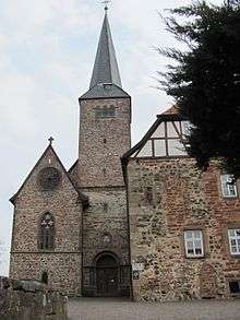
The oldest documented local establishment was the Benedictine abbey of Schlüchtern. A foundation document allegedly signed by Charlemagne was discovered to be a medieval forgery. A possible first mention of the abbey dates from 819, but cannot be attributed without doubt to this location. The earliest mention that irrefutably referred to Schlüchtern Abbey dates from 993, when Otto III granted the abbey sluohderin to the Bishop of Würzburg.[2]:239-40
The abbey became influential and by the High Middle Ages had acquired substantial land holdings far beyond the Kinzig valley. However, by the late Middle Ages its power was already waning. The Peasants' War and the Reformation accelerated its decline. The last (Protestant) abbot, Johannes Wankel, died in April 1609. Today, the monastery buildings continue to serve as a Gymnasium (school) and education facility for the regional Protestant church.[2]:240-1
The abbey church, rebuilt in Gothic style in the 15th century, became a teacher's seminary in 1835/6. However, the crypt from Carolingian times has been preserved.[2]:241-2
An ancient trade route, the Eselsweg connected Schlüchtern to Großheubach/Miltenberg on the river Main.
Infrastructure
Transportation
Schlüchtern is connected to the Frankfurt Rhine-Main region by the A 66 and the Kinzig Valley Railway (Kinzigtalbahn) at Schlüchtern station, both connecting Frankfurt am Main and Fulda.
References
- ↑ "Bevölkerung der hessischen Gemeinden". Hessisches Statistisches Landesamt (in German). August 2016.
- 1 2 3 4 Jüngling, Peter (1994). Hanau und der Main-Kinzig-Kreis - Führer zu archäologischen Denkmälern in Deutschland 27 (German). Theiss. pp. 239–44. ISBN 3-8062-1119-1.
External links
| Wikimedia Commons has media related to Schlüchtern. |