Bad Soden-Salmünster
| Bad Soden-Salmünster | ||
|---|---|---|
|
Salmünster with Saints Peter and Paul Church | ||
| ||
 Bad Soden-Salmünster | ||
Location of Bad Soden-Salmünster within Main-Kinzig-Kreis district 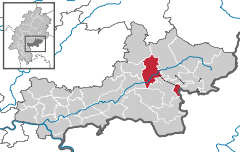
 | ||
| Coordinates: 50°16′N 09°22′E / 50.267°N 9.367°ECoordinates: 50°16′N 09°22′E / 50.267°N 9.367°E | ||
| Country | Germany | |
| State | Hesse | |
| Admin. region | Darmstadt | |
| District | Main-Kinzig-Kreis | |
| Government | ||
| • Mayor | Lothar Büttner | |
| Area | ||
| • Total | 58.62 km2 (22.63 sq mi) | |
| Population (2015-12-31)[1] | ||
| • Total | 13,361 | |
| • Density | 230/km2 (590/sq mi) | |
| Time zone | CET/CEST (UTC+1/+2) | |
| Postal codes | 63628 | |
| Dialling codes | 06056 | |
| Vehicle registration | MKK | |
| Website | www.badsoden-salmuenster.de | |


Bad Soden-Salmünster is a town in the Main-Kinzig district, in Hesse, Germany. It is situated on the river Kinzig, between Fulda and Hanau. It has a population of around 13,000.
Geography
Location
The municipality is located on both sides of the Kinzig river in the Main-Kinzig district of Hesse. Its territory extends into the hills of the Vogelsberg to the north and into the Spessart to the south.
The two main population centres, Bad Soden and Salmünster, are both situated in the Kinzig valley.
Subdivisions
The Stadt (town) Bad Soden-Salmünster today consists of the following 11 Stadtteile (boroughs): Ahl, Alsberg, Bad Soden, Hausen, Eckardroth, Katholisch-Willenroth, Kerbersdorf, Mernes, Romsthal, Salmünster and Wahlert.
Bad Soden and Salmünster are the two Kernstadtteile (core boroughs). The current municipality was created in the Gebietsreform of 1970, 1972 and 1974.[2]
Neighbouring communities
From the north, clockwise, the neighbouring municipalities are: Birstein, Steinau an der Straße, Gutsbezirk Spessart (an unincorporated area surrounding the Stadtteil of Alfeld), Bad Orb, Wächtersbach and Brachttal. The Stadtteil Mernes is separated from the rest of the municipal territory by the Gutsbezirk Spessart. It also borders on Forst Aura (another unincorporated wooded area and part of the Main-Spessart district of Bavaria) and Jossgrund.
History

Soden has been a Heilbad (spa) and therefore called "Bad Soden" since 1928.[3]
Creation of the current town
The current town was created only on 1 July 1974 when the towns of Salmünster and Bad Soden bei Salmünster merged. During earlier Gebietsreformen, as of 1 December 1970 Wahlert had become a part of Bad Soden. Ahl and Eckardroth followed on 1 April 1972. Alsberg and Hausen were merged with Salmünster on 1 January 1970 followed by Kerbersdorf and Romsthal on 1 December 1970 and Katholisch-Willenroth on 1 July 1972.[4]
Since 1974, the town has been part of the Main-Kinzig district, it was previously part of the Schlüchtern district.[4]
Government
The mayor is Lothar Büttner.
Notable buildings

- Burg Stolzenberg - ruin of a medieval hill castle to the northeast of Bad Soden. It was destroyed in the Thirty Years' War by Croatian troops serving the Emperor, commanded by Johann Ludwig Hektor von Isolani.[5]
- Huttenschloss Bad Soden - a town castle built around 1536 by Lukas von Hutten[6]
- St. Peter und Paul (Salmünster) - the current Baroque church was built in 1737-45. It is part of the ensemble of the Franciscan monastery at Salmünster.[6]
- Schloss Hausen (Bad Soden) - the original castle was first mentioned in 1540. Under Daniel Brendel von Homburg it was rebuilt into a small Schloss. Today, it serves as a youth hostel and is not open to the public.[7]
- St. Laurentius - Gothic revival church at Bad Soden
- Wallfahrtskirche Heiliges Kreuz - small church at Alsberg
- Mernes water works - water works built in 1914 by the Prussians to supply water to the military training area between Bad Orb and Jossgrund. It was bought in 1952 by the city of Frankfurt, when it once again took over the summer camp at Wegscheide (see Stalag IX-B). The Mernes works long supplied water to the camp until it was replaced with a new water line from Bad Orb. Mernes still uses water pumped from the works.[8]
Infrastructure
Transportation
The town has direct access to the Autobahn 66 from Frankfurt to Fulda. It is linked to the rail network by the Bad Soden-Salmünster station (located in the Stadtteil of Salmünster).
Utilities
At Ahl, the Kinzig is dammed by the Kinzigtalsperre, which serves both to control floods and to generate hydroelectric power.
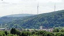
Like in other communities in the area, such as Biebergemünd, Flörsbachtal, Bad Orb and Jossgrund, there is currently controversy over plans to build additional towering wind farms on the wooded peaks. A number of these have already been built in the neighbouring town of Wächtersbach very close to the municipal boundary. Environmentalists and many locals reject these plans due to the destruction of forests and animal habitats, possible health risks to residents, as well as threats to local property values and, in particular, to the tourism business as a result of a declining attractiveness of the region to visitors. It is also questioned whether local winds are strong and constant enough to allow economical operation of the wind farms.[9]
Notable residents
- Kurt Lamm (1919–87), footballer, coach, manager, and administrator
- Joseph Müller (1894-1944), priest
References
- ↑ "Bevölkerung der hessischen Gemeinden". Hessisches Statistisches Landesamt (in German). August 2016.
- ↑ Statistisches Bundesamt (1983). Historisches Gemeindeverzeichnis für die Bundesrepublik Deutschland. Namens-, Grenz- und Schlüsselnummernänderungen bei Gemeinden, Kreisen und Regierungsbezirken vom 27. 5. 1970 bis 31. 12. 1982. W. Kohlhammer GmbH, Stuttgart und Mainz. pp. 376–7. ISBN 3-17-003263-1.
- ↑ "Bad Soden bei Salmünster, Main-Kinzig-Kreis, in: Historisches Ortslexikon (German)". Hessisches Landesamt für geschichtliche Landeskunde. Retrieved 29 June 2015.
- 1 2 "Historisches Ortslexikon: Bad Soden-Salmünster(German)". Landesgeschichtliches Informationssystem. Retrieved 28 August 2015.
- ↑ "Historisches Ortslexikon: Burg Stolzenberg(German)". Landesgeschichtliches Informationssystem. Retrieved 28 August 2015.
- 1 2 "Sehenswürdigkeiten (German)". Gemeinde Bad Soden-Salmünster. Retrieved 28 August 2015.
- ↑ "Hausen (German)". Gemeinde Bad Soden-Salmünster. Retrieved 28 August 2015.
- ↑ Seipel, Regine (21 January 2014). "Ungeliebter Schatz(German)". Frankfurter Rundschau. Retrieved 28 August 2015.
- ↑ "Pressespiegel (List of various newspaper articles, German)". Bürgerinitiative Windkraft im Spessart e.V. Retrieved 28 August 2015.
| Wikimedia Commons has media related to Bad Soden-Salmünster. |