San Juan River (Calamba)
| San Juan River | |
|---|---|
| Country | Philippines |
| Basin | |
| Main source |
Malvar Batangas 10m(deepest) |
| River mouth |
Southern part of Laguna de Bay less than 2 meters (6.6 ft) above sea level |
| Basin size | 25.50m |
| Physical characteristics | |
| Length | over all:177.80km Laguna de bay to Mt malepunyo (Lipa Batangas) |
| Discharge |
|
The San Juan River (Tagalog: Ilog ng San Juan) is a river system in Calamba City, Philippines. It is one of 21 major tributaries of Laguna de Bay and is regularly monitored by the Laguna Lake Development Authority (LLDA) through one of its 15 river monitoring stations.
Along with the San Cristobal River, it is one of the two major rivers of Calamba that drains into Laguna de Bay.[1] Its watershed area covers Calamba City in Laguna and the municipalities of Santo Tomas, Tanauan, and Malvar in Batangas.[2]
Monitoring and Conservation
In the December 2005 LLDA Water Quality Status Report, the San Juan River was listed as "worse than Class D" with a very low percentage of dissolved oxygen saturation. It also indicated that this status had not improved since the river had last been monitored.
According to the Department of Environment and Natural Resources's Water Usage & Classification for Fresh Water, Class D freshwater is suitable for agriculture, irrigation, livestock watering and industrial water supply class II. "Worse than Class D" means that the San Juan is not usable for any of these functions.[3]
The LLDA's conservation efforts for the major tributaries and watersheds of Laguna de Bay have led to the creation of the Laguna de Bay River Basin Councils, of which the MTSC-San Juan River Protection Fdn., Inc. is particularly tasked with the conservation of the San Juan.[4]
Sources
- ↑ World Bank Environmental Assessment Report: Calamba, Laguna, August 1997, retrieved 2007-09-30
- ↑ Final List of Watersheds Supporting 140 River Irrigation System of the NIA (PDF), 2006, retrieved 2007-09-30
- ↑ Liongson, Leonardo (November 23–24, 2000). "Data Monitoring and Needs" (PDF). Proceedings of the Workshop/Discussions on Integrated Manila Bay/Laguna Lake System and Surrounding Watersheds. Hotel Rembrandt, Quezon City: Japan Society for the Promotion of Science. p. 120. Retrieved 2007-09-30.
- ↑ Cariño, Jose III (2007), Integrated Water Resources Management: The Laguna de Bay Experience (PDF), retrieved 2007-09-30
See also
"The Largest Lake in the Philippines" | |||||||||||
| Location | 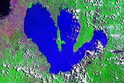 | ||||||||||
| Basin country | |||||||||||
| Islands | |||||||||||
| Primary outflow | |||||||||||
| Primary inflows |
| ||||||||||
| Settlements | |||||||||||
Coordinates: 14°13′00″N 121°10′01″E / 14.2167°N 121.1670°E