San Antonio River (California)
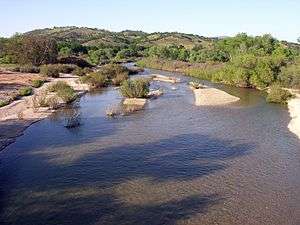
The San Antonio River is a 58.8-mile-long (94.6 km)[1] river in southern Monterey County, California. The river was used as an irrigation source for Mission San Antonio de Padua.
Geography
The river travels southeast from its headwaters in the Santa Lucia Range in the Los Padres National Forest and into Lake San Antonio. This is a reservoir behind the San Antonio Dam, an earth-fill dam on the river that forms the largest lake in the county. Downstream from the dam, the river travels east until it joins the Salinas River.
The Nacimiento River, which feeds Lake Nacimiento and is also a Salinas River tributary, and mirrors the San Antonio River's path several miles to the southwest.
Ecology
After depletion by 19th century fur trappers, California golden beaver (Castor canadensis subauratus) have expanded their range from the San Antonio River below the reservoir to the Salinas River mainstem.[2]
References
- ↑ U.S. Geological Survey. National Hydrography Dataset high-resolution flowline data. The National Map, accessed March 15, 2011
- ↑ Barry Parr (2007). Explore! Big Sur Country A Guide to Exploring the Coastline, Byways, Mountains, Trails, and Lore. Globe Pequot. p. 174. ISBN 978-0-7627-3568-6. Retrieved 2010-12-16.