Salla Willk'i Punta
| Salla Willk'i Punta | |
|---|---|
 Salla Willk'i Punta Location within Bolivia | |
| Highest point | |
| Elevation | 4,560 m (14,960 ft) [1] |
| Coordinates | 17°02′56″S 66°28′47″W / 17.04889°S 66.47972°WCoordinates: 17°02′56″S 66°28′47″W / 17.04889°S 66.47972°W |
| Geography | |
| Location |
Bolivia, Cochabamba Department |
| Parent range | Andes |
Salla Willk'i Punta (Aymara salla rocks, cliffs, willk'i gap,[2] also spelled Salla Willkhi Punta) is a mountain in the Bolivian Andes which reaches a height of approximately 4,560 m (14,960 ft). It is located in the Cochabamba Department, Ayopaya Province, Morochata Municipality. It lies north of the lakes named Q'umir Qucha ("green lake", Khomer Khocha), Yana Qucha ("black lake", Yana Khocha), Parinani ("the one with flamingos") and Wallatani ("the one with Andean geese", Huallatani).[1][3]
References
- 1 2 Bolivia 1:100,000 Quillacollo 3636
- ↑ Radio San Gabriel, "Instituto Radiofonico de Promoción Aymara" (IRPA) 1993, Republicado por Instituto de las Lenguas y Literaturas Andinas-Amazónicas (ILLLA-A) 2011, Transcripción del Vocabulario de la Lengua Aymara, P. Ludovico Bertonio 1612 (Spanish-Aymara-Aymara-Spanish dictionary)
- ↑ "Morochata". INE, Bolivia. Retrieved April 1, 2016.
Capital: Cochabamba | ||
| Provinces | 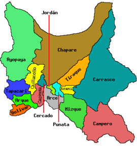 | |
| Municipalities (and seats) |
| |
This article is issued from Wikipedia - version of the 4/1/2016. The text is available under the Creative Commons Attribution/Share Alike but additional terms may apply for the media files.