Cochabamba Department
| Cochabamba Department Quchapampa suyu | |||
|---|---|---|---|
| Department | |||
| |||
| Nickname(s): "City of Eternal Spring" | |||
 Location within Bolivia | |||
| Country |
| ||
| Established as department by law | 1826 | ||
| Autonomous department by referendum | 2009 | ||
| Capital | Cochabamba | ||
| Government | |||
| • Governor | Edmundo Novillo Aguilar | ||
| Area | |||
| • Department | 55,631 km2 (21,479 sq mi) | ||
| Elevation | 2,574 m (8,445 ft) | ||
| Population (2012) | |||
| • Department | 1,758,143 | ||
| • Urban | 608,276 | ||
| Time zone | BOT (UTC-4) | ||
| HDI (2004) | - | ||
| ISO 3166-2 | BO-C | ||
| Website | http://www.cochabamba.gob.bo/ | ||


Cochabamba (Aymara: Quchapampa Jach'a Suyu, Spanish: Departamento de Cochabamba, Quechua: Quchapampa Suyu), from Quechua qucha or qhucha, meaning "lake", pampa meaning "plain",[1] is one of the nine departments of Bolivia. It is known to be the "granary" of the country because of its variety of agricultural products from its geographical position. It has an area of 55,631 km². Its population in the 2012 census was 1,758,143. Its capital is the city of Cochabamba, known as the "City of Eternal Spring" and "The Garden City" because of its spring-like temperatures all year.
History
The Cochabamba valley was inhabited for over a thousand years due to its fertile productive soils and climate. Archaeological evidence suggests that the initial valley inhabitants were of various ethnic indigenous groups. Tiwanaku, Tupuraya, Mojocoya, Omereque and Inca inhabited the valley at various times before the Spanish arrived.
The first Spanish inhabitant of the Valley was Garci Ruiz de Orellana in 1542. He purchased the majority of the land from local tribal chiefs Achata and Consavana through a title registered in 1552 at the Imperial City of Potosí. The price paid was 130 pesos. His residence, known as the House of Mayorazgo, still stands in the Cala Cala neighbourhood of the city.
The city, called Villa de Oropesa was founded on 2 August 1571 by order of Viceroy Francisco de Toledo, Count of Oropesa. It was to be an agricultural production centre to provide food for the mining towns of the relatively nearby Altiplano region, particularly the city of Potosí which became one of the largest and richest cities in the world during the 17th century – funding the vast wealth that ultimately made Spain a world power at the time. With the silver mining industry in Potosi at its height, Cochabamba thrived during its first centuries of existence. The city entered a period of decline during the 18th century as mining began to wane.
In 1786, King Charles III of Spain renamed the city to the 'loyal and valiant' Villa of Cochabamba. This was done to commend the city's pivotal role in suppressing the indigenous rebellions of 1781 in Oruro by sending armed forces to Oruro to quell the uprisings. Since the late 19th century it has again been generally successful as an agricultural centre for Bolivia.
The 1793 census shows that the city had a population of 22,305 persons. There were 12,980 mestizos, 6,368 Spaniards, 1,182 indigenous natives, 1,600 mulattos and 175 African slaves.
In 2000, Cochabamba was wracked by large-scale protests over the privatisation of the city's water supply, known as the Water War.
In January 2007 city dwellers clashed with mostly rural protestors, leaving four dead and over 130 injured. The democratically-elected Prefect of Cochabamba, Manfred Reyes Villa, a former military aide to the Luis García Meza dictatorship of the 1980s, had allied himself with the leaders of Bolivia's Eastern Departments in a dispute with President Evo Morales over regional autonomy and other political issues. The protestors blockaded the highways, bridges, and main roads, having days earlier set fire to the departmental seat of government, trying to force the resignation of Reyes Villa. Citizens attacked the protestors, breaking the blockade and routing them, while the police did little to stop the violence. Further attempts by the protestors to reinstate the blockade and threaten the government were unsuccessful, but the underlying tensions have not been resolved.
In July 2007, a monument erected by veterans of January's protest movement in honour of those killed and injured by government supporters was destroyed in the middle of the night, reigniting racial conflicts in the city.
In August 2008, a nationwide referendum was held, and while the president Evo Morales had 67% support in Bolivia, the prefect of Cochabamba, Manfred Reyes Villa, was not confirmed by the voters of the department.
Geography
Cochabamba Department is bordered by Chuquisaca and Potosi Department to the south, Oruro and La Paz Department to the west, Beni Department to the north, and Santa Cruz Department to the east. The borders are formed mainly by rivers, like Ichilo to the east, Rio Grande to the south and Cotacajes to the west.[2]
Government
The chief executive office of Bolivia departments (since May 2010) is the governor; until then, the office was called the prefect, and until 2006 the prefect was appointed by the President of Bolivia. The current governor, Iván Canelas of the Movement for Socialism – Political Instrument for the Sovereignty of the Peoples (MAS–IPSP) was elected on 29 March 2015 and took office on 31 May.
The MAS–IPSP has been the dominant political party in the department since the 2008 recall referendum. Under the 2009 Constitution, Bolivian departments have an elected legislature, the Departmental Legislative Assembly. The Cochabamba Assembly has 34 members including two indigenous representatives.
The most recent election results are as follows:
| Gubernatorial Candidate | Party | Votes for Governor | Percentage | Assembly Members by Territory | Votes for Assembly by Population | Percentage | Assembly Members by Population | Total Assembly Members | |
|---|---|---|---|---|---|---|---|---|---|
| Edmundo Novillo Aguilar | Movement for Socialism | 415.245 | 61,9% | 16 | 360.785 | 60,7% | 11 | 27 | |
| Marvell José María Leyes Justiniano | National Unity Front-Popular Consensus (All for Cochabamba) | 174.175 | 26,0% | 0 | 147.442 | 24,8% | 4 | 4 | |
| José Ronald Del Barco Alcocer | Without Fear Movement | 52.516 | 7,8% | 0 | 63.614 | 10,7% | 1 | 1 | |
| María Casta Jaimes Arriaran | Nationalist Revolutionary Movement | 29.250 | 4,4 | 0 | 22.800 | 3,8% | 0 | 0 | |
| Indigenous Representatives | Elected through usos y costumbres by the Yuqui and Yuracaré peoples | 2 | |||||||
| Valid votes | 671.186 | 81,9% | 594.641 | 72,7% | |||||
| Blank votes | 111.510 | 13,6 | 183.077 | 22,4% | |||||
| Null votes | 36.905 | 4,5% | 40.713 | 5,0% | |||||
| Total votes | 819.601 | 87,2% of registered voters | 16 | 818.431 | 87,1% of registered voters | 16 | 34 | ||
| Source: Corte Nacional Electoral, Acto de Computo Nacional | |||||||||
Past executives
| Date Began | Date Ended | Prefect/Governor | Party | Notes |
|---|---|---|---|---|
| 10 Jun 1999 | 8 Apr 2000 | Hugo Galindo Saucedo | Appointed prefect by President Hugo Banzer through Supreme Decree 25411. Resigned during the 2000 Cochabamba water protests after his advice to concede protester demands was ignored. | |
| 8 Apr 2000 | 10 Apr 2000 | Eduardo Wayar Cortéz | Police commander. Appointed interim prefect via Supreme Decree 25734 on the same day a state of siege was declared by President Hugo Banzer. | |
| 10 Apr 2000 | Walter Céspedes Ramallo | Appointed prefect via Supreme Decree 25735. | ||
| 23 Jan 2006 | 12 Aug 2008 | Manfred Reyes Villa | New Republican Force | First elected prefect. Elected in Bolivian general election, December 2005, and removed by the 2008 recall election. |
| 12 Aug 2008 | 26 Aug 2008 | Johnny Gutierrez Ferrel (acting, de facto) | ||
| 29 Aug 2008 | 12 Dec 2008 | Rafael Puente Calvo (acting) | MAS-IPSP | |
| 12 Dec 2008 | 30 May 2010 | Jorge Ledezma Cornejo (interim) | MAS-IPSP | Final prefect |
| 30 May 2010 | 31 May 2015 | Edmundo Novillo Aguilar | MAS-IPSP | Elected in regional election on 4 April 2010; first governor |
| 31 May 2015 | Iván Canelas | MAS-IPSP | Elected in regional election on 29 March 2015. | |
| Source: worldstatesmen.org | ||||
Provinces
The Department of Cochabamba is divided into 16 provinces (provincias) which are further subdivided into 47 municipalities [3] (municipios) and – on the fourth level – into 144 cantons.
The provinces with their capitals and population according to census 2012 are listed as follow:
| Province | Capital | Area (km²) | Population (2012 census) |
 |
|---|---|---|---|---|
| Arani | Arani | 506 | 18,444 | |
| Arque | Arque | 1.077 | 20,630 | |
| Ayopaya | Ayopaya | 9.620 | 54,408 | |
| Bolívar | Bolívar | 413 | 7,279 | |
| Capinota | Capinota | 1.495 | 29,659 | |
| Carrasco | Totora | 15.045 | 135,097 | |
| Cercado | Cochabamba | 391 | 630,587 | |
| Chapare | Sacaba | 12.445 | 262,845 | |
| Esteban Arce | Tarata | 1.245 | 37,152 | |
| Germán Jordán | Cliza | 305 | 34,342 | |
| Mizque | Mizque | 2.730 | 35,586 | |
| Narciso Campero | Aiquile | 5.550 | 35,763 | |
| Punata | Punata | 850 | 54,409 | |
| Quillacollo | Quillacollo | 720 | 335,393 | |
| Tapacarí | Tapacarí | 1.500 | 24,595 | |
| Tiraque | Tiraque | 1.739 | 41.954 |
Languages
The languages spoken in the Cochabamba Department are mainly Spanish and Quechua. The following table shows the number of those belonging to the recognised group of speakers.[4]
| Language | Department | Bolivia |
|---|---|---|
| Quechua | 872,010 | 2,281,198 |
| Aymara | 84,921 | 1,525,321 |
| Guaraní | 1,379 | 62,575 |
| Another native | 3,351 | 49,432 |
| Spanish | 1,101,822 | 6,821,626 |
| Foreign | 40,579 | 250,754 |
| Only native | 269,588 | 960,491 |
| Native and Spanish | 648,195 | 2,739,407 |
| Spanish and foreign | 454,273 | 4,115,751 |
Population and Demographics
| Description | Department 1976 | Department 1992[5] | Department 2001[5] | Department 2012[6] |
|---|---|---|---|---|
| Inhabitants | 720.952 | 1.110.205 | 1.455.711 | 1.758.143 |
| Rural | - | - | 41 % | - |
| Urban | - | - | 59 % | - |
| Total fertility rate | - | 4.00 | ||
| Infant mortality | - | 72.00 | ||
| Annualized decade growth rate |
- | 3.46 | 2.93 | 1.68 |
| Net migration rate | - | - | 2.40 | - |
Economy
The Cochabamba economy is based mainly in services, but recently it is experiencing some diversification in manufacturing, agriculture and tourism. The geographic location of Cochabamba makes it the main routes of transport joining the two main cities, the host government La Paz and the industrial hub Santa Cruz. Therefore, many cervices i.e. transport, banking, telecommunication, gastronomy, are economically important in the corridor La Paz – Santa Cruz. Extraction of oil was very important for the economy in the past; especially in Chapare where the wells are located. By 2013 many of the exploited wells were showing signs of depletion. Thus, investment is needed to find new productive wells. Once called “the basket grain of Bolivia” today Cochabamba produces just a portion of the agriculture output of the country. Overpopulation in the productive valleys and “minifundio” doomed the once competitive production. Nevertheless, Cochabamba is still important in poultry, dairy, tropical fruits, potatoes, among others. Recently, Cochabamba experiences some improvement in manufacturing and industry. The cement mill of COBOCE located in Capinota almost triples the production tapering the strong demand. The roads to the industrial park and other facilities of the park were improved making it more competitive for the local and new industries. Also, it is worth to mention the almost 1b USD government investment in the petro chemistry (urea plant) located in Bulo Bulo.
Places of interest
- Carrasco National Park
- Tunari National Park
- Isiboro Sécure National Park and Indigenous Territory
- Inkallaqta
- Inkachaka
- Inka Raqay
- Quillacollo
- Villa Tunari
- Laguna La Angostura
- Payrumani: The Payrumani estate about 20 km from the city of Cochabamba comprises Villa Albina, a landed estate which was property of the Bolivian industrialist Simón I. Patiño, built between 1925 and 1932, a model farm and seed centre and a Centre for Phytoecogenetic Research.[7] The palace of Payrumani was declared Bolivian National Monument in 1967.
See also
References
- ↑ Diccionario Bilingüe Iskay simipi yuyayk'ancha pdf
- ↑ Andes Travel Map
- ↑ www.bolivia.com (English)
- ↑ obd.descentralizacion.gov.bo Archived February 18, 2009, at the Wayback Machine. (Spanish)
- 1 2 "Cochabamba: indicadores Sociodemográficos por Provincia y Scciones de Provincia 1992–2001" (PDF). Instituto Nacional de Estadística de Bolivia. Archived (PDF) from the original on 13 November 2010.
- ↑ "Bolivia: Censo Nacional de Población y Vivienda 2012" (PDF). Instituto Nacional de Estadística de Bolivia. Archived (PDF) from the original on 9 February 2014.
- ↑ Pairumani
External links
| Wikivoyage has a travel guide for Cochabamba Department. |
- Cochabamba Travel Guide
- Weather in Cochabamba
- Bolivian Music and Web Varieties
- Pictures: Coca cultivation in the Cochabamba Tropic
- Full information of Cochabamba Department
Capital: Cochabamba | ||
| Provinces | 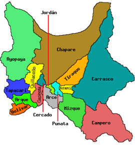 | |
| Municipalities (and seats) |
| |
Coordinates: 17°20′S 65°30′W / 17.333°S 65.500°W