Saint-Hippolyte, Quebec
| Saint-Hippolyte | |
|---|---|
| Municipality | |
 Location within La Rivière-du-Nord RCM. | |
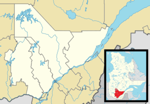 Saint-Hippolyte Location in central Quebec. | |
| Coordinates: 45°56′N 74°01′W / 45.933°N 74.017°WCoordinates: 45°56′N 74°01′W / 45.933°N 74.017°W[1] | |
| Country |
|
| Province |
|
| Region | Laurentides |
| RCM | La Rivière-du-Nord |
| Constituted | July 1, 1855 |
| Government[2] | |
| • Mayor | Bruno Laroche |
| • Federal riding | Rivière-du-Nord |
| • Prov. riding | Rousseau |
| Area[2][3] | |
| • Total | 132.60 km2 (51.20 sq mi) |
| • Land | 120.65 km2 (46.58 sq mi) |
| Population (2011)[3] | |
| • Total | 8,083 |
| • Density | 67.0/km2 (174/sq mi) |
| • Pop 2006-2011 |
|
| Time zone | EST (UTC−5) |
| • Summer (DST) | EDT (UTC−4) |
| Postal code(s) | J8A 1A1 |
| Area code(s) | 450 and 579 |
| Highways |
|
| Website |
www |
Saint-Hippolyte is a municipality within La Rivière-du-Nord Regional County Municipality in the Laurentides region of Quebec, in the Laurentian mountains about 45 km north of Montreal. The name comes from Saint Hippolytus.
Part of the town was formerly known as Abercrombie-Est.
Police services are provided by the Régie intermunicipale de police de la Rivière-du-Nord, which also serves Piedmont, Prévost and some other communities in the Laurentians.
Demographics
Population trend:[4]
- Population in 2011: 8083 (2006 to 2011 population change: 12.0%)
- Population in 2006: 7219
- Population in 2001: 6039
- Population in 1996: 5672
- Population in 1991: 4697
Private dwellings occupied by usual residents: 3,558 (total dwellings: 4,784)
Mother tongue:
- English as first language: 4.7%
- French as first language: 92.6%
- English and French as first language: 1%
- Other as first language: 1.7%
References
- ↑ Reference number 56730 of the Commission de toponymie du Québec (French)
- 1 2 Geographic code 75045 in the official Répertoire des municipalités (French)
- 1 2 "(Code 2475045) Census Profile". 2011 census. Statistics Canada. 2012.
- ↑ Statistics Canada: 1996, 2001, 2006, 2011 census
 |
Sainte-Adèle | Chertsey | | |
| Piedmont Prévost |
|
Saint-Calixte | ||
| ||||
| | ||||
| Sainte-Sophie | Saint-Lin-Laurentides |
| Towns | |
|---|---|
| Municipalities | |
| |
This article is issued from Wikipedia - version of the 12/16/2013. The text is available under the Creative Commons Attribution/Share Alike but additional terms may apply for the media files.