Saint-Alexandre-de-Kamouraska, Quebec
| Saint-Alexandre-de-Kamouraska | |
|---|---|
| Municipality | |
 | |
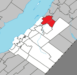 Location within Kamouraska RCM | |
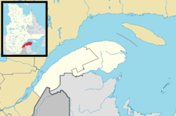 Saint-Alexandre-de-Kamouraska Location in eastern Quebec | |
| Coordinates: 47°40′54″N 69°37′30″W / 47.68167°N 69.62500°WCoordinates: 47°40′54″N 69°37′30″W / 47.68167°N 69.62500°W[1] | |
| Country |
|
| Province |
|
| Region | Bas-Saint-Laurent |
| RCM | Kamouraska |
| Constituted | July 1, 1855 |
| Government[2] | |
| • Mayor | Victor Morin |
| • Federal riding | Montmagny—L'Islet—Kamouraska—Rivière-du-Loup |
| • Prov. riding | Côte-du-Sud |
| Area[2][3] | |
| • Total | 116.50 km2 (44.98 sq mi) |
| • Land | 111.49 km2 (43.05 sq mi) |
| Population (2011)[3] | |
| • Total | 2,050 |
| • Density | 18.4/km2 (48/sq mi) |
| • Pop 2006-2011 |
|
| • Dwellings | 870 |
| Time zone | EST (UTC−5) |
| • Summer (DST) | EDT (UTC−4) |
| Postal code(s) | G0L 2G0 |
| Area code(s) | 418 and 581 |
| Highways |
|
| Website |
www |
Saint-Alexandre-de-Kamouraska is a municipality in the Canadian province of Quebec, located in the Kamouraska Regional County Municipality.
Before July 5, 1997, it was known simply as Saint-Alexandre.
Geography
Lakes and rivers
The following waterways pass through or are situated within the municipality's boundaries:[1]
- Lac Morin (47°37′23″N 69°32′08″W / 47.62306°N 69.53556°W) – located along the municipality's southern border.
- Le Petit Lac (47°40′10″N 69°33′41″W / 47.66944°N 69.56139°W)
- Petite rivière Noire (47°41′38″N 69°32′33″W / 47.69389°N 69.54250°W)
- Rivière Carrier (47°40′11″N 69°30′42″W / 47.66972°N 69.51167°W)
- Rivière Fourchue (47°41′19″N 69°32′31″W / 47.68861°N 69.54194°W)
See also
References
External links
-
 Media related to Saint-Alexandre-de-Kamouraska, Quebec at Wikimedia Commons
 |
Notre-Dame-du-Portage | | ||
| Saint-André | |
Saint-Antonin | ||
| ||||
| | ||||
| Saint-Joseph-de-Kamouraska | Picard |
| Cities & Towns | |
|---|---|
| Municipalities | |
| Parishes | |
| Unorganized territories | |
| |
This article is issued from Wikipedia - version of the 12/1/2016. The text is available under the Creative Commons Attribution/Share Alike but additional terms may apply for the media files.