Södermalm
 18th century housing facing Riddarfjärden | |
 Södermalm | |
| Geography | |
|---|---|
| Location | Baltic Sea |
| Coordinates | 59°19′N 18°04′E / 59.317°N 18.067°E |
| Area | 5.71 km2 (2.20 sq mi) |
| Administration | |
|
Sweden | |
| Borough | Södermalm borough |
| Municipality | Stockholm Municipality |


Södermalm, often shortened to "Söder" (Swedish for "south"), is a district and island in central Stockholm.
Overview
The district covers the large island of the same name (formerly called "Åsön"). Although Södermalm usually is considered an island, water to both its north and south does not flow freely but passes through locks.
Södermalm is connected to its surrounding areas by a number of bridges. It connects to Gamla stan to the north by Slussen, a grid of road and rail and a lock that separates the lake Mälaren from the Baltic Sea, to Långholmen to the northwest by one of the city's larger bridges, Västerbron, to the islet Reimersholme to the west, to Liljeholmen to the southwest by the bridge Liljeholmsbron, to Årsta by Årstabron and Skansbron, to Johanneshov by Johanneshovsbron and Skanstullsbron to the south, and, finally, to Södra Hammarbyhamnen to the east by Danvikstull Bridge.
Administratively, Södermalm is part of Stockholm Municipality. It constitutes, together with Gamla stan and some other districts, from 2007 the administrative district Södermalms stadsdelsområde, often translated as Södermalm borough.
History
The name Södermalm ("suthraemalm") is first mentioned in 1288 in a letter from Bishop Anund of Strängnäs. Until the early 17th century Södermalm was mainly a rural, agricultural area.[1] Its first urban areas were planned and built in the mid 17th century, comprising a mixture of working class housing, such as the little red cottages of which a few can still be seen in northeastern Södermalm, and the summer houses and pavilions of wealthier families, such as Emanuel Swedenborg's pavilion, which is now in the outdoor museum Skansen. During this time, it was also the location of perhaps the first theatre in Scandinavia, Björngårdsteatern. Södermalm is often poetically named "Söders höjder", which reflects its topography of sheer cliffs and rocky hills. Indeed, the hills of Södermalm provide remarkable views of Stockholm's skyline.
In the 18th century, the working-class cottages that clung to Mariaberget, the steep cliffs facing Riddarfjärden, were replaced by the large buildings that are still present today. It was not until the beginning of the 20th century that urbanisation grasped the entire width of Södermalm, and even today parts of Södermalm have a rural feeling to them, as for instance the landscape of tiny allotments that climb the slopes of Eriksdal.
Also, rather than being known as a slum, Södermalm is now known as home of bohemian, alternative culture and a broad range of cultural amenities. Meanwhile, the growing demand of housing, as well as an increasing gentrification of Stockholm's central parts, makes apartments in Södermalm more and more difficult or expensive to come by. Thus what was once a working-class district is now somewhat a district of the privileged.[2]
Geography
Neighbourhoods and parishes
There are four parishes of the Church of Sweden on the island (from west to east):
- Högalid, partitioned from the parish of Maria Magdalena in 1925.
- Maria Magdalena, partitioned from the Stockholm Cathedral parish in 1591, and subsequently divided into the modern parishes.
- Katarina, partitioned from Maria Magdalena in 1654.
- Sofia, partitioned from Katarina in 1917 and also includes parts of the mainland south of Södermalm.
Södermalm is roughly divided into the following neighbourhoods (from west to east):
- Högalid (western area):
- Bergsund
- Drakenberg
- Heleneborg
- Tantolunden
- Zinkensdamm
- Maria Magdalena (mid-northern area):
- Mariaberget
- Mariatorget
- Slussen
- Södra stationsområdet
- Åsö (mid-southern area):
- Eriksdal
- Helgalund
- Medborgarplatsen
- Rosenlund
- Skanstull
- Katarina-Sofia (north-eastern area):
- Blecktornsområdet
- Danvikstull
- Ersta
- Norra Hammarbyhamnen
- Nytorget
- Mosebacke
Main sights
- Göta Lejon
- Högalid Church
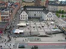
- Karl Johanslussen
- Katarina Elevator
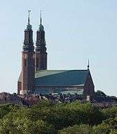
- Katarina Church
- Maria Magdalena Church
- Medborgarhuset
- Stockholm Mosque
- St. Eric's Cathedral
- Skatteskrapan
- Slussen
- Södra teatern
- Sofia kyrka
- Stockholm South Station
- Söder Torn
- Nytoget
Culture
In poetry and fiction
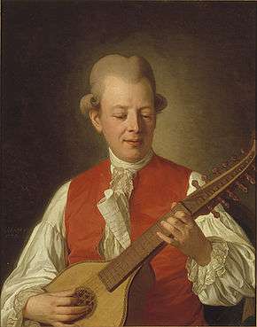
- The songs and poems (Fredman's Songs and Fredman's Epistles) of the popular 18th century poet and songwriter Carl Michael Bellman are filled with recurring references to names of places, primarily bars and meadhalls, on Södermalm.[3][4]
- The celebrated first paragraph of August Strindberg's satirical novel The Red Room (Röda rummet) describes Stockholm as seen from Mosebacke on Södermalm, where much of the story takes place.
- City of My Dreams (Mina drömmars stad), the first in a series of books by Per Anders Fogelström telling the story of several generations of Stockholmers, follows the young worker Henning's life on Södermalm.
- Lisbeth Salander and other characters in the Millennium Trilogy by Stieg Larsson live and work on Södermalm. Much of the action in those books takes place in that district.
- Greta Garbo grew up in the area.
Transport
Railway and Stockholm metro stations
|
Bridges |
See also
References
| Wikimedia Commons has media related to Södermalm. |
| Wikivoyage has a travel guide for Södermalm. |
- ↑ "Stockholm Stories". Retrieved 14 April 2014.
- ↑ Franzén, M. "New social movements and gentrification in Hamburg and Stockholm: A comparative study." Journal of Housing and the Built Environment 20 (2005): 51-77.
- ↑ "Bellmanmuseet". Time Out.
- ↑ "Bellmanhuset". Bellmanhuset. Retrieved 10 March 2016.
Coordinates: 59°19′N 18°04′E / 59.317°N 18.067°E