São Bento (Angra do Heroísmo)
| São Bento | |
| Civil Parish | |
| Official name: Freguesia de São Bento | |
| Name origin: Portuguese for Saint Benedict | |
| Country | |
|---|---|
| Autonomous Region | |
| Island | Terceira |
| Municipality | Angra do Heroísmo |
| Localities | Caboucos, Canada da Fontinha, Canada do Vale, Carreirinha, Escopins, São Luís, Vale de Linhares |
| Center | São Bento |
| - elevation | 65 m (213 ft) |
| - coordinates | 38°39′35″N 27°12′23″W / 38.65972°N 27.20639°WCoordinates: 38°39′35″N 27°12′23″W / 38.65972°N 27.20639°W |
| Highest point | Terrerinhos |
| - location | Serra do Morião |
| - elevation | 621 m (2,037 ft) |
| - coordinates | 38°41′48″N 27°11′54″W / 38.69667°N 27.19833°W |
| Lowest point | Sea Level |
| - location | Atlantic Ocean |
| Area | 10.34 km2 (4 sq mi) |
| - urban | 1.03 km2 (0 sq mi) |
| Population | 2,000 (2011) |
| Settlement | fl. 1500 |
| - Parish | c. 1572 |
| LAU | Junta Freguesia |
| - location | Rua do Arco |
| - coordinates | 38°40′10″N 27°12′20″W / 38.66944°N 27.20556°W |
| President Junta | Luís Salvador |
| Timezone | Azores (UTC-1) |
| - summer (DST) | Azores (UTC0) |
| Postal Zone | 9700-213 |
| Area Code & Prefix | (+351) 292 XXX-XXXX |
| Patron Saint | São Bento |
| Wikimedia Commons: São Bento (Angra do Heroísmo) | |
| Website: http://www.jfsaobento.com/ | |
| Geographic detail from Instituto Geográfico Português (2010) | |
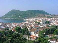
São Bento is a parish in the municipality of Angra do Heroísmo on the island of Terceira in the Azores. The population in 2011 was 2,000,[1] in an area of 10.34 km².[2] The parish lies at an elevation of 65 metres above sea level.
References
This article is issued from Wikipedia - version of the 6/26/2014. The text is available under the Creative Commons Attribution/Share Alike but additional terms may apply for the media files.