Ruth's Church
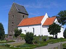
Ruth's Church (Danish: Ruts Kirke) is a parish church located in the village of Rutsker near Hasle on the Danish island of Bornholm. The church was built in the early 13th century in the Romanesque style. Situated on a hilltop 130 m above sea level, it is the island's highest-standing church.[1][2]
History
The oldest reference to the church dates from 1490 where Sancti Michelssogen (St Michael's Parish) is mentioned. The church was initially consecrated as St Michael's, possibly because of its high location. By 1621, the name had become Ruth's Church (ecclesia Rutziana) after Ruth the Moabite in the Old Testament. The church was probably built in the 13th century with a nave and chancel. The tower at the west end and the porch on the south side were added later. The chancel and the finely rounded apsis are part of the original structure. At the end of the 19th century, the north wing was added. The old tower and porch were removed a little later, the nave was lengthened by some 3 metres and a new tower was built.[2]
Belltower
Constructed in the second half of the 16th century, the belltower in the churchyard is said to be the oldest on the island. It has not, however, been used since 1886 when the bells were transferred to the new tower at the west end of the church.[2]
Frescos and font
In 1908, frescos were discovered in the late Gothic apsis vaults. Depicting the signs of the evangelists, they were restored in 1930. Next to the fresco of Matthew, the date 1559 can be seen. Also of interest is the granite Romanesque font which is almost cylindrical in shape.[3]
.jpg) The old bell tower
The old bell tower.jpg) Nave and chancel
Nave and chancel.jpg) Frescos in the apsis
Frescos in the apsis.jpg) The rounded apsis
The rounded apsis.jpg) The font
The font
See also
References
- ↑ "Ruts kirke (Rutsker)", Kirker på Bornholm. (Danish) Retrieved 28 June 2012.
- 1 2 3 Otto Norn, C. G. Schultz, Erik Skov, Ruts Kirke: Bornholms Nørre Herred, Danmarks Kirker, Bornholm, Nationalmuseet, Gad, 1954, pp. 297–325. (Danish)
- ↑ "Ruts kirke", Nordens kirker. (Danish) Retrieved 28 June 2012.
| Wikimedia Commons has media related to Ruts Kirke. |
Coordinates: 55°12′55″N 14°45′01″E / 55.21528°N 14.75028°E
 | |
| Towns & villages | |
| Localities | |
| Churches | |
| Culture | |
| Fortifications | |
| Lighthouses | |
| Windmills | |
| Beauty spots |
|
| Transport | |
| Attractions | |