Rue de la Commune
Coordinates: 45°30′18″N 73°33′12″W / 45.505102°N 73.553235°W
 | |
| Former name(s) | Rue des Commissaires |
|---|---|
| Length | 2.3 km (1.4 mi) |
| Coordinates | 45°30′18″N 73°33′12″W / 45.505102°N 73.553235°W |
Rue de la Commune is a road in Old Montreal which is well used both by Montrealers and by tourists, since it is the home of the Pointe-à-Callière Museum and the Old Port of Montreal. The road follows the original shore of the Saint Lawrence River. The buildings along the north side of the road are former commercial buildings.
History
In 1651, the governor of Montréal, Paul Chomedey de Maisonneuve granted land to Jean de Saint-Père to be used as pasture. This 'commune' (commons) is a strip of land one arpent wide with 40 arpents of shoreline.
The river bank was the site of a tow path, and became a road, lined with grain elevators from 1879. A proposed elevated highway along the river over the Rue de la Commune spurred a movement to preserve the district. Dutch-born architect and urban planner Daniel van Ginkel played a major role in saving the district from destruction during the early 1960s. As assistant director of the city of Montreal's newly formed planning department, he persuaded authorities to abandon plans for an expressway that would have cut through the old city.[1] In 1964, most of Old Montreal was classified as an historic district
In 1970, the road was renamed from rue des Commissaires, in memory of early colonial days. After the Port of Montreal was moved, the area became a recreational area in 1992.
Gallery
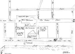 Map of Ville-Marie, 1672 by François Dollier de Casson
 c. 1884
 c. 1910
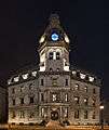 357 rue de la Commune Ouest
References
- ↑ Martin, Sandra (July 23, 2009). "Sandy van Ginkel rescued Old Montreal from freeway developers". Globe and Mail. Retrieved 2009-07-24.