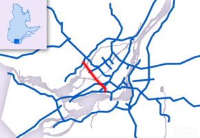
Quebec Autoroute 13
| ||||
|---|---|---|---|---|
| Autoroute Chomedey | ||||
 | ||||
| Route information | ||||
| Maintained by Transports Québec | ||||
| Length: | 21.4 km[1][2] (13.3 mi) | |||
| Existed: | 1975 [2] – present | |||
| Major junctions | ||||
| South end: |
| |||
|
| ||||
| North end: |
| |||
| Location | ||||
| Major cities: | Montreal, Laval, Boisbriand | |||
| Highway system | ||||
| ||||
Autoroute 13 (or A-13, also known as Autoroute Chomedey with sections formerly known as Autoroute Mirabel), is a freeway in the urban region of Montreal, Quebec, Canada. Its southern end is at the junction of A-20 on the Island of Montreal near Pierre Elliott Trudeau International Airport. Its northern terminus is at the junction of A-640 near Boisbriand. The road traverses through Laval.
Autoroute 13 was built as a toll highway in 1975 with a goal to connect the two international airports, Mirabel and Dorval (now Trudeau International Airport). The freeway is mostly six-laned and tolls no longer apply.
The designation of Autoroute Chomedey refers to the community of Chomedey in Laval, through which A-13 passes. Formerly, common usage was to refer to the autoroute as Autoroute Chomedey south of the Milles-Îles river, and Autoroute Mirabel north of that point. In recent usage, however, the Autoroute Chomedey name is generally used for the full length of the autoroute. Boulevard Pitfield is routed as a parallel service road to A-13 in St-Laurent.
Boulevard Pitfield derives its name from the origin of the actual route. In the 1920s, the actual route was a Polo Pony Trail leading from the various estates of the Saraguay Village residents to their Polo Fields, now where the area of St. Laurent Blvd and Bois Franc merge. In the late 1930s the path became an unpaved local road. Over the next several decades Saraguay Farms, owned by Mrs. W.C. Pitfield, was paid to clear the road in the winter by the municipality of St. Laurent. The road was developed into a two-lane highway in the 1960s.
The Quebec provincial government was planning to extend Autoroute 13 north of A-640 in the late 1990s as an alternate route for A-15 (Autoroute Décarie/Autoroute des Laurentides). It is speculated this extension is less of a priority since Mirabel ceased passenger operations in 2004, and the Mirabel site is well-served by A-15 and A-50.
Interchanges from south to north
| Municipality | No. | Intersecting Roads | Notes |
|---|---|---|---|
| Lachine | 1 | ||
| Saint-Laurent Lachine |
2 | Montée de Liesse / Rue Hickmore | |
| Saint-Laurent Lachine Dorval |
3 | ||
| Saint-Laurent | 6 | ||
| Saint-Laurent Pierrefonds |
8 | Boulevard Henri-Bourassa / Boulevard Gouin | |
| Louis Bisson Bridge over the Rivière des Prairies | |||
| Laval | 12 | Boulevard Samson / Boulevard Notre-Dame / (Boulevard Saint-Martin) | (Northbound only) |
| 15 | (Boulevard Saint-Martin) (Southbound only) / Rue Principale (directly from the south bound service road only) | ||
| 17 | Boulevard Dagenais / Boulevard Sainte-Rose | ||
| Vachon Bridge over the Rivière des Mille Îles | |||
| Boisbriand | 20 | ||
| 22 | |||

- Lowest Annual Average Daily Traffic: 38 000 (between R-344 and A-640 in 2000)
- Highest Annual Average Daily Traffic: 140 000 (between A-40 and A-440 in 2000)
References
- ↑ Ministère des transports, "Distances routières", page (?), Les Publications du Québec, 2005
- 1 2 "Répertoire des autoroutes du Québec" (in French). Transports Québec. Retrieved 2008-02-23.
External links
| Wikimedia Commons has media related to Quebec Autoroute 13. |
- Transport Quebec website
- Transport Quebec map (French)
- A-13 at Exitlists.com
- A-13 at Quebec Autoroutes
- Steve Anderson's MontrealRoads.com: Chomedey Autoroute (A-13)