Ruddock, Louisiana
| Ruddock, Louisiana | |
|---|---|
| Ghost town | |
 Ruddock, Louisiana | |
| Coordinates: 30°12′16″N 90°25′30″W / 30.20444°N 90.42500°WCoordinates: 30°12′16″N 90°25′30″W / 30.20444°N 90.42500°W | |
| Country | United States |
| State | Louisiana |
| Parish | St. John the Baptist |
| Elevation | 3 ft (0.9 m) |
| GNIS feature ID | 1628080[1] |
Ruddock is a ghost town in St. John the Baptist Parish, Louisiana, United States. Ruddock was located on an isthmus between Lake Maurepas and Lake Pontchartrain, 10 miles (16 km) north-northeast of LaPlace.
Although the town was destroyed by a hurricane in 1915, it is still signed as an exit on Interstate 55 and marked on Louisiana state highway maps, as of 2011.[2]
History
In 1892, William Burton and C. H. Ruddock founded the Ruddock Cypress Company. They constructed a sawmill and a town to serve their business; the town became Ruddock. In 1902, the sawmill burned down and was later rebuilt. By 1910, the town had a population of 700.
In September 1915, the 1915 New Orleans Hurricane hit Ruddock, destroying the town and killing 58 residents of Ruddock and the nearby town of Frenier. Ruddock has since become overgrown by vegetation, and all that remains of the settlement is rotted wood from the buildings.[3]
References
- ↑ U.S. Geological Survey Geographic Names Information System: Ruddock, Louisiana
- ↑ 2010 Official Highway Map of Louisiana (PDF) (Map). Louisiana Department of Transportation and Development. 2010. Retrieved 2011-09-29.
- ↑ Hastings, Robert W. (2009). The Lakes of Pontchartrain: Their History and Environments. University Press of Mississippi. p. 319.
Municipalities and communities of St. John the Baptist Parish, Louisiana, United States | ||
|---|---|---|
| CDPs | 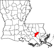 | |
| Unincorporated communities | ||
| Ghost town | ||
| Footnotes | ‡This populated place also has portions in an adjacent parish | |