Japan National Route 6
| |
|---|---|
| Kokudō Roku-gō (国道6号) | |
 | |
| Route information | |
| Length: | 353.6 km (219.7 mi) |
| Highway system | |
|
National highways of Japan Expressways of Japan | |


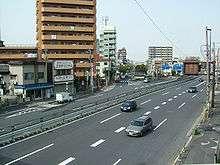
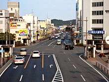
National Route 6 (国道6号 Kokudō Roku-gō) is a Japanese highway from Tokyo to Sendai that goes through the cities Mito, Iwaki and Sōma. It traces the old Mito Kaidō route from Tokyo to Mito,[1][2] and, for much of its 353.6 kilometres (219.7 mi) length, runs parallel to the Jōban railway line and the Jōban Expressway.
Features
Originating in Chūō, Tokyo (at Nihonbashi, which also marks the origins of Routes 1, 4, 14, 15, 17 and 20), it ends in Miyagino-ku, Sendai (at the Nigatake interchange, junction with Route 45, also the origin of Route 47)
Major cities and villages it passes through include: Kashiwa, Toride, Tsuchiura, Ishioka, Mito, Hitachi, Iwaki, Tomioka, Ōkuma, Sōma, Watari, Iwanuma
The actual terminus is Iwanuma in Miyagi (at the Fujinami intersection) which is the junction of Routes 4 and 6. In the areas north of Iwanuma which overlap with the Route 4, signboards for Route 6 are not posted. The distance from Tokyo to Iwanuma is at total 334.0 kilometres (207.5 mi). This is equivalent to the distance from Mito to Kakegawa / Ichinoseki.
Lengthened Tōkaidō
Route 6 is a part of the lengthened Tōkaidō which connects the Kansai region (Kinai), or Nara and Kyoto in particular, and the Pacific coast of Tōhoku (called the Tagajō).
During the Ritsuryō period, roads from Kinai to the Tagajō were divided into two: the Tōkaidō eastern sea road (via Nagoya, Hamamatsu, Tokyo and Mito) and the Tōsandō eastern mountain road (via Gifu, Shiojiri, Takasaki and Utsunomiya).
During the foundation of Kamakura Kanagawa, Ritsiryō Tōkaidō was divided into two roads: the westward Tōkaidō which connects southern Kantō (Kamakura, Edo, Tokyo) and Kyoto, and the northward Tōkaidō which connects southern Kantō and Pacific coasts of Tōhoku. Since the foundation of Edo, Tōkaidō was narrowed by the Tokugawa Shogunate, the westward Tōkaidō functioned as a seaside road to Kyoto and the northward Tōkaidō functioned as one to the Pacific coasts of Tōhoku.
Ritsuryō Tōkaidō, west from Tokyo is now the Route 1, Ritsuryō Tōkaidō, north from Tokyo, Route 6.
Nuclear dense zone
One side of Route 6 is known as the "nuclear dense zone". Tōkaimura (the first nuclear power plant of Japan), Ōkuma (center of the Fukushima Daiichi nuclear disaster) and Naraha (location of the Fukushima Daini Nuclear Power Plant) are located on adjacent of Route 6.
History
- 4 December 1952: Named the First Class National Highway 6 (from Tokyo to Sendai)
- 1 April 1965: Renamed General National Highway 6 (from Tokyo to Sendai)
- 12 March 2011: Due to the Fukushima Daiichi nuclear disaster, Route 6 suspended between Hirono and Haranomachi.
Overlapping sections
The following sections of Route 6 overlap with other routes:
- In Chuo, Tokyo, from the origin point to Muromachi intersection: Route 17
- In Chuo, Tokyo, from the origin point to Honchō 3-chōme intersection: Route 4
- In Chuo, Tokyo, from the origin point to Asakusa-bashi intersection: Route 14
- From Kashiwa, Chiba to Toride: Route 294
- In Tsuchiura: Route 125 and Route 354
- In Ishioka: Route 355
Intersections with other routes
- Route 16 in Kashiwa: Ōmiya, Saitama (west) and Chiba (southeast)
- Route 125 in Tsuchiura: Koga, Ibaraki and Kumagaya (west) and Kashima, Ibaraki and Katori, Chiba (east)
- Route 50 in Mito, Ibaraki: Utsunomiya, Oyama, Tochigi, and Takasaki
- Route 51 in Mito: Kashima and Narita
- Route 461 in Takahagi: Ōtawara, Nikkō, and Numata, Gunma
- Route 289 in Nakoso (southern Iwaki): Shirakawa, Tajima, and Tadami, Fukushima
- Route 49 in Iwaki, Fukushima: Kōriyama, Aizuwakamatsu, and Niigata
- Route 288 in Ōkuma, Fukushima: Kōriyama, Aizuwakamatsu, and Niigata
- Route 115 in Sōma, Fukushima: Fukushima (Nakadōri), Inawashiro, and Yonezawa, Murakami
- Route 113 in Shinchi, Fukushima : Shiroishi, Miyagi, Nanyō, Yamagata, and Murakami
Suspension due to nuclear disaster
Due to the Fukushima Daiichi nuclear disaster, access is prohibited to a zone of 20 kilometres (12 mi) radius from the Fukushima Daiichi NPP. Route 6 was blocked for non-authorized traffic between Hirono (the Iwaki side) and Haranomachi (the Sōma side). The ban was lifted in September 2014 after the road decontamination, and vehicles with exception of motorcycles and bicycles, are allowed to pass the stretch.[3]
References
| Wikimedia Commons has media related to Route 6 (Japan). |
- ↑ 一般国道6号 (in Japanese). Ministry of Land, Infrastructure, Transport and Tourism. Kanto Regional Development Bureau. Retrieved 2010-11-29.
- ↑ Chiba Kokaidō Rekishi Sanpo. Ministry of Land, Infrastructure and Transport. Accessed December 28, 2007.
- ↑ "Cars allowed to use highway section closed by Fukushima nuclear crisis". The Japan Times. 15 September 2014. Retrieved 15 February 2015.