Utsunomiya
| Utsunomiya 宇都宮市 | |||
|---|---|---|---|
| Core city | |||
|
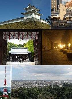
Utsunomiya Castle, Statue of gyoza Futaarasan Shrine, Oya Stone Museum Utsunomiya Tower, City view from the tower | |||
| |||
 Location of Utsunomiya in Tochigi Prefecture | |||
 Utsunomiya
| |||
| Coordinates: 36°33′18.4″N 139°52′57.2″E / 36.555111°N 139.882556°ECoordinates: 36°33′18.4″N 139°52′57.2″E / 36.555111°N 139.882556°E | |||
| Country | Japan | ||
| Region | Kantō | ||
| Prefecture | Tochigi Prefecture | ||
| Government | |||
| • Mayor | Eiichi Sato | ||
| Area | |||
| • Total | 416.85 km2 (160.95 sq mi) | ||
| Population (Feb 2016) | |||
| • Total | 519,461 | ||
| • Density | 1,250/km2 (3,200/sq mi) | ||
| Time zone | Japan Standard Time (UTC+9) | ||
| - Tree | Ginkgo biloba | ||
| - Flower | Satsuki azalea | ||
| Phone number | 028-632-2222 | ||
| Address | 1-1-5, Asahi, Utsunomiya-shi, Tochigi-ken 320-8540 | ||
| Website | Official website | ||


.JPG)
Utsunomiya (宇都宮市 Utsunomiya-shi) is the capital and most populous city of Tochigi Prefecture, in the northern Kantō region of Japan. As of May 2015, the city had an estimated population of 518,200 and a population density of 1240 persons per km². Its total area was 416.85 km². Utsunomiya is famous for its gyoza (pan fried dumplings). There are more than two hundred gyoza restaurants in Utsunomiya.[1]
Greater Utsunomiya (宇都宮都市圏 Utsunomiya Toshi-ken) had a population of 888,005 in the 2000 Census. The nearby city of Oyama is included in Greater Tokyo, but Greater Utsunomiya is not, despite the two areas amalgamating somewhat. It is the 10th most populated city in the Kanto region.
Geography
Utsunomiya is located in south-central Tochigi Prefecture in the northern Kantō plains. It is approximately 100 km north of Tokyo. The historic town of Nikkō is approximately 25 km northwest of Utsunomiya. The average altitude of the city is 100 meters.
Surrounding municipalities
Climate
Utsunomiya has a humid subtropical climate (Köppen climate classification Cfa) with hot and humid summers and cool winters. Precipitation is heavy in the summer wet season, especially from July to September, and it is noticeably drier in the winter months from December to February.
| Climate data for Utsunomiya, Tochigi (1981–2010) | |||||||||||||
|---|---|---|---|---|---|---|---|---|---|---|---|---|---|
| Month | Jan | Feb | Mar | Apr | May | Jun | Jul | Aug | Sep | Oct | Nov | Dec | Year |
| Record high °C (°F) | 21.0 (69.8) |
24.6 (76.3) |
25.9 (78.6) |
30.4 (86.7) |
33.2 (91.8) |
37.5 (99.5) |
38.7 (101.7) |
37.5 (99.5) |
36.5 (97.7) |
32.5 (90.5) |
25.1 (77.2) |
24.7 (76.5) |
38.7 (101.7) |
| Average high °C (°F) | 8.3 (46.9) |
9.1 (48.4) |
12.6 (54.7) |
18.5 (65.3) |
22.5 (72.5) |
25.2 (77.4) |
28.7 (83.7) |
30.5 (86.9) |
26.4 (79.5) |
20.9 (69.6) |
15.5 (59.9) |
10.7 (51.3) |
19.1 (66.4) |
| Daily mean °C (°F) | 2.5 (36.5) |
3.3 (37.9) |
6.8 (44.2) |
12.5 (54.5) |
17.2 (63) |
20.6 (69.1) |
24.2 (75.6) |
25.6 (78.1) |
21.9 (71.4) |
16.1 (61) |
10.1 (50.2) |
4.9 (40.8) |
13.8 (56.8) |
| Average low °C (°F) | −2.7 (27.1) |
−1.9 (28.6) |
1.5 (34.7) |
7.0 (44.6) |
12.5 (54.5) |
16.9 (62.4) |
20.8 (69.4) |
22.2 (72) |
18.4 (65.1) |
11.8 (53.2) |
5.0 (41) |
−0.7 (30.7) |
9.3 (48.7) |
| Record low °C (°F) | −14.8 (5.4) |
−13.3 (8.1) |
−12.4 (9.7) |
−6.4 (20.5) |
−0.8 (30.6) |
4.7 (40.5) |
10.3 (50.5) |
11.4 (52.5) |
5.5 (41.9) |
−2.7 (27.1) |
−6.7 (19.9) |
−10.9 (12.4) |
−14.8 (5.4) |
| Average precipitation mm (inches) | 33.9 (1.335) |
42.9 (1.689) |
88.4 (3.48) |
120.5 (4.744) |
146.6 (5.772) |
174.7 (6.878) |
205.8 (8.102) |
209.8 (8.26) |
220.4 (8.677) |
146.5 (5.768) |
68.1 (2.681) |
35.5 (1.398) |
1,493.1 (58.784) |
| Average snowfall cm (inches) | 10 (3.9) |
10 (3.9) |
5 (2) |
0 (0) |
0 (0) |
0 (0) |
0 (0) |
0 (0) |
0 (0) |
0 (0) |
0 (0) |
3 (1.2) |
28 (11) |
| Average precipitation days (≥ 0.5 mm) | 4.4 | 5.9 | 9.9 | 11.1 | 12.5 | 14.8 | 16.2 | 12.7 | 14.2 | 11.1 | 7.1 | 4.0 | 123.9 |
| Average snowy days | 3.6 | 3.8 | 1.9 | 0.2 | 0.0 | 0.0 | 0.0 | 0.0 | 0.0 | 0.0 | 0.0 | 1.1 | 10.6 |
| Average relative humidity (%) | 62 | 60 | 61 | 64 | 70 | 77 | 80 | 78 | 79 | 74 | 71 | 66 | 70.2 |
| Mean monthly sunshine hours | 204.8 | 186.2 | 187.9 | 179.5 | 166.9 | 112.1 | 114.1 | 138.9 | 112.2 | 145.0 | 164.5 | 199.1 | 1,911.2 |
| Source #1: Japan Meteorological Agency[2] | |||||||||||||
| Source #2: Japan Meteorological Agency (records)[3] | |||||||||||||
History
Archaeologists have uncovered evidence that the area of Utsunomiya has been continuously settled since the Japanese Paleolithic period onwards, and numerous burial mounds from the Kofun period are found within its borders. The Utsunomiya Futarayama Shrine (宇都宮二荒山神社), which is the Ichinomiya of Shimotsuke Province claims to have been founded in 353 AD. The town of Utsunomiya developed around this shrine, and the area was under the control of the Utsunomiya clan, an offshoot of the Fujiwara clan from the Heian through Sengoku periods, and was destroyed by Toyotomi Hideyoshi.
During the Edo period, the Utsunomiya area was ruled by a succession of daimyo clans under Utsunomiya Domain, and prospered from its location at the junction of the Nikkō Kaidō and the Ōshū Kaidō. During the Bakumatsu period Boshin War, the Battle of Utsunomiya Castle was a major conflict in the northern Kanto area. Following the Meiji restoration, Utsunomiya was briefly (1871-1873) part of Utsunomiya Prefecture, which was then merged into the new Tochigi Prefecture, and became capital of the prefecture in 1884. Utsunomiya became an important garrison for the Imperial Japanese Army.
With the establishment of the municipalities system on April 1, 1889, the town of Utsunomiya was officially established. At the end of the 1889, Utsunomiya had a population of 30,698 making it the third most populous municipality in the Kanto area, after Tokyo and Yokohama. Utsunomiya was raised to city status on April 1, 1896. On July 12, 1945 much of Utsunomiya and the surrounding areas were destroyed in the American Bombing of Utsunomiya during World War II.
The city limits were expanded from 1951-1955 by annexing neighboring Suzumenomiya town and Hiraishi, Yokokawa, Mizuhono, Kunimoto, Shiroyama, Tomiya, Toyosato, and Sugatagawa villages and the part of Shinoi village from Kawachi District and Kiyohara village from Haga District. In 1996, Utsunomiya was designated a core city within increased autonomy. On March 31, 2007, Utsunomiya absorbed the towns of Kamikawachi and Kawachi (both from Kawachi District), pushing the population of Utsunomiya City over 500,000.
Economy
Utsunomiya is the commercial and industrial center of Tochigi Prefecture. Utsunomiya is home to a Canon optical manufacturing plant, a Japan Tobacco plant, Honda design centers, and various other industrial concerns in the Kiyohara Industrial Park. In addition, one of the largest malls in the north Kantō region, Bell Mall is located near central Utsunomiya.
Education
- Utsunomiya University
- Sakushin Gakuin University
- Bunsei University of Art
- Utsunomiya Kyowa University
- Utsunomiya Junior College
- Teikyo University Utsunomiya campus
- Utsunomiya has 70 elementary schools, 31 junior high schools, and 17 high schools.
Transportation
Rail
Utsunomiya is served by the high-speed Tohoku Shinkansen line from Tokyo, as well as a number of suburban lines operated by East Japan Railway Company (JR East) and the private railway operator Tobu Railway.
- East Japan Railway Company (JR East) - Tohoku Shinkansen
- JR East – Tohoku Main Line (Utsunomiya Line/Shōnan-Shinjuku Line/Ueno-Tokyo Line)
- Suzumenomiya - Utsunomiya - Okamoto
- JR East - Nikkō Line
- Tsuruta - Utsunomiya
- Tobu Railway - Tobu Utsunomiya Line
Construction of a Light Rapid Transit system is planned, with completion scheduled for December 2019.[4]
Highways
- Tōhoku Expressway
- Nikkō Utsunomiya Road
- Kita-Kantō Expressway
- National Route 4
- National Route 119
- National Route 121
- National Route 123
- National Route 293
- National Route 408
Local attractions
- site of Utsunomiya Castle
- site of Tobuyama Castle
- Ōya-ji – a Buddhist temple including a museum with artifacts dating back to the Jōmon Period.
Sports
- Utsunomiya is represented in the J. League of football with its local club Tochigi S.C..
- Tochigi Green Stadium
- Kiyohara Baseball Stadium
- Utsunomiya Velodrome - Utsunomiya is the host city of the Japan Cup, a UCI sanctioned cycling race, held on October 20 and 21, 2012.
Sister cities
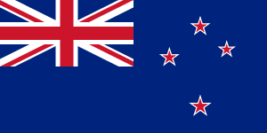 Auckland (then Manukau City), New Zealand, sister city since February 24, 1982[5]
 Tulsa, Oklahoma, United States of America, sister city since July 10, 1992 [6]
 Qiqihar, Heilongjiang, China, Friendship-city since September 30, 1984 [7]
 Orléans, France, Friendship-city since May 7, 1989 [8]
Notable people
- Kozue Ando – professional football player
- Minori Chihara – voice actress
- Nanae Chrono – manga artist
- Yukio Edano – politician
- Hajime Funada – politician
- Naoya Kondo – professional football player
- Ikuo Matsumoto – professional football player
- Masako Mori – singer
- Toshio Nobe – manga artist
- Sadao Watanabe – jazz musician
- Susumu Yanase – politician
References
- ↑ Szymanski, Andrew (2009-09-21). "Welcome to Utsunomiya - gyoza town | CNN Travel". Cnngo.com. Retrieved 2014-02-10.
- ↑ "平年値(年・月ごとの値)". Japan Meteorological Agency. Retrieved 2011-11-26.
- ↑ "観測史上1~10位の値(年間を通じての値)". Japan Meteorological Agency. Retrieved 2011-11-26.
- ↑ 宇都宮市などが国交省に申請 /栃木 Mainichi Shimbun. Retrieved 2016-1-23.
- ↑ Manukau City Council - Sister City. Retrieved on 11 October 2008
- ↑ Sister Cities International
- ↑ Qiqihar Official site
- ↑ Orleans Department of Tourism
External links
| Wikimedia Commons has media related to Utsunomiya, Tochigi. |
| Wikivoyage has a travel guide for Utsunomiya. |
- Official website (Japanese)