Roura
| Roura | ||
|---|---|---|
|
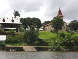
Roura as seen from the Oyak River | ||
| ||
 Location of the commune (in red) within French Guiana | ||
| Coordinates: 4°43′27″N 52°19′17″W / 4.7242°N 52.3215°WCoordinates: 4°43′27″N 52°19′17″W / 4.7242°N 52.3215°W | ||
| Country | France | |
| Overseas region and department | French Guiana | |
| Arrondissement | Cayenne | |
| Intercommunality | Centre Littoral | |
| Government | ||
| • Mayor (2014-2020) | David Riché | |
| Area1 | 3,659 km2 (1,413 sq mi) | |
| Population (2012)2 | 3,050 | |
| • Density | 0.83/km2 (2.2/sq mi) | |
| INSEE/Postal code | 97310 / 97311 | |
| Elevation |
0–462 m (0–1,516 ft) (avg. 231 m or 758 ft) | |
|
1 French Land Register data, which excludes lakes, ponds, glaciers > 1 km² (0.386 sq mi or 247 acres) and river estuaries. 2 Population without double counting: residents of multiple communes (e.g., students and military personnel) only counted once. | ||
.svg.png)
Roura is a commune of French Guiana, an overseas region and department of France located in South America.
Location
The city of Roura is bordered by Matoury and Montsinéry-Tonnegrande in the North, Kourou and Saint-Elie in the North West and West, and finally by Régina in the South and East.
Roads
The city of Roura is home to 2 main roads.
- The RD6 road leads to the landing stage of Kaw.This 70 km long road follows a thalweg through the primal forest.
- The N2 road leads to Régina and Saint-Georges cities.
See also
References
| Wikimedia Commons has media related to Roura. |
This article is issued from Wikipedia - version of the 6/6/2016. The text is available under the Creative Commons Attribution/Share Alike but additional terms may apply for the media files.