Rooty Hill, New South Wales
| Rooty Hill Sydney, New South Wales | |||||||||||||
|---|---|---|---|---|---|---|---|---|---|---|---|---|---|
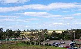 Rooty Hill, seen from the railway station. In the background is the hill from which the area gets its name. | |||||||||||||
| Coordinates | 33°46′18″S 150°50′38″E / 33.771543°S 150.843922°ECoordinates: 33°46′18″S 150°50′38″E / 33.771543°S 150.843922°E | ||||||||||||
| Population | 13,377 (2011 census)[1] | ||||||||||||
| • Density | 2,123/km2 (5,500/sq mi) | ||||||||||||
| Postcode(s) | 2766 | ||||||||||||
| Area | 6.3 km2 (2.4 sq mi) | ||||||||||||
| Location | 42 km (26 mi) west of Sydney CBD | ||||||||||||
| LGA(s) | City of Blacktown | ||||||||||||
| State electorate(s) | Mount Druitt | ||||||||||||
| Federal Division(s) | Chifley | ||||||||||||
| |||||||||||||
Rooty Hill is a suburb of Sydney, in the state of New South Wales, Australia. Rooty Hill is located 42 kilometres west of the Sydney central business district, in the local government area of the City of Blacktown and is part of the Greater Western Sydney region.
History
The earliest exploration of the area was led by Captain Watkin Tench in 1789.[2] The origin of this name puzzled historians for many years because the clue lay not in Blacktown City but on Norfolk Island. Governor Philip Gidley King had been in charge of the first settlement there in early 1788 and had noted that the hillside where he had built his Government House had been difficult to dig owing to the amount of tree roots beneath the surface. The hill on Norfolk became known as Rooty Hill and the name is now official.[3] When King returned to New South Wales he built the headquarters for his government reserve of 1802 at the foot of a hill that reminded him of the Norfolk Island Rooty Hill and used the same name.[4] The name Rooty Hill first appeared on a map in 1803.
The early development of the area came when Captain William Minchin was given a grant of 400 hectares (1,000 acres) in 1819, leading to the development of the Minchinbury estate. Dr Charles McKay purchased the estate in 1859 and subdivided it in the 1880s. Afterwards, the Watts family built Watts Cottage in Watt Street. It combines Italianate elements with a bullnose verandah and is almost unique in the Blacktown Municipality. It is heritage-listed.[5]
In 1890, the Imperial Hotel was built north of the railway station by F.J. Weston. It was intended to cater for the crowds who attended the greyhound racing at Lamb's Woodstock Coursing Track at Plumpton. By the early 1970s it had become semi-derelict, but was acquired by a local dentist in 1977. It reopened in 1982 and is now heritage-listed.[6]
In 1891, the Pioneer Memorial Church, located on Rooty Hill Road South, was built on land donated by Dr Charles McKay. It was originally a Baptist church, but was later acquired for the Presbyterian community by James Angus, owner of the Minchinbury estate from 1895. It is still in use and is heritage-listed.[7]
In 1902–1903, the School of Arts, located in Rooty Hill Road South, was built by the residents for community activities. The foundation stone was laid November 1, 1902, by Miss Angus,[8] daughter of James Angus. It is heritage-listed.[9]
On 13 April 1916, James Angus was killed at Rooty Hill railway crossing, as a result of being hit by that morning's express train. He was survived by his wife, his son James (of Adelaide), his son John (a pastoralist in New South Wales) and his daughter, who by that time was the widow Mrs Fleming.[10]
The name of James Angus is preserved in Angus Avenue; Charles McKay's name survives in Dr Charles McKay Reserve; the name of the Evans family, who built Fairholme, survives in Evans Road. Fairholme, now part of the St Agnes Catholic High School, is heritage-listed.[11]
Demographics
- The most common ancestries in Rooty Hill were Filipino 18.8%, Australian 16.1%, English 13.4%, Indian 4.2% and Irish 3.4%.
- The most common countries of birth were Philippines 16.7%, Fiji 3.4%, India 2.4%, New Zealand 2.4% and England 1.5%.
- The most common responses for religion were Catholic 43.8%, Anglican 11.4%, No Religion 6.5%, Islam 5.6% and Hinduism 5.4%.
- 49.3% of people only spoke English at home. Other languages spoken at home included Tagalog 10.6%, Filipino 6.4%, Hindi 4.2%, Arabic 2.8% and Urdu 1.9%.
Commercial area
The main commercial area of Rooty Hill is primarily on Rooty Hill Road North and Rooty Hill Road South, immediately surrounding the railway station.
 Rooty Hill Road South shops
 The Imperial Hotel, Rooty Hill Road North
Rooty_Hill_School_of_Arts-2.jpg) Rooty Hill School of Arts, built 1902
Rooty Hill School of Arts, built 1902 Railway line dividing Rooty Hill as seen from Davis overpass
Pioneer_Memorial_Church-1.jpg) Heritage-listed Pioneer Memorial Church on Rooty Hill Road South
Heritage-listed Pioneer Memorial Church on Rooty Hill Road SouthWatts_Cottage_Rooty_Hill-1.jpg) Watts Cottage, Watt Street
Watts Cottage, Watt Street Rooty Hill RSL Club with Holiday Inn Rooty Hill
St_Agnes_High_School_Rooty_Hill-2a.jpg) Fairholme, built by the Evans family, now part of St Agnes Catholic High School
Fairholme, built by the Evans family, now part of St Agnes Catholic High School
Schools

- Rooty Hill Public School is a New South Wales public school providing education from Kindergarten to Year 6.[12] It has been on Rooty Hill Road North since its opening in 1957 with 114 students. The entire class of the opening year attended the 50th anniversary celebrations held in May 2007. Member for Chifley, Roger Price commented that ..the influence a school can have on a student lasts their lifetime. Having the entire class of 1957 at the (50th anniversary) celebration shows just how positive that can be.[13]
- St. Aidans Primary School (Kindergarten-Year 6), located in Adelaide Street, was founded in 1907.[14]
- St. Agnes Catholic High School (Years 7-10),[15] Evans Road, Rooty Hill is a secondary school located in Rooty Hill South. Established in 1962, the school is a part of the Christ Catholic College Community of schools which was established in 1999, and which is a system of three schools that broke apart in 2004 - the other two schools being Clare Catholic High School in Hassall Grove, and Loyola Senior High School in Mt Druitt, which is the only Senior High School in the Parramatta Diocese. In late 2004, St Agnes underwent a major building development, with a new building containing six classrooms, a library and an undercroft, which would provide easy access to the school hall. In late 2007, the school underwent a whole-campus redevelopment.
- Rooty Hill High School (Years 7-12). North Parade, Rooty Hill. Rooty Hill High School is a comprehensive, 7 to 12 community school in Western Sydney.[16]
Churches
- St. Albans Anglican Multicultural Bible Ministry (MBM)[17] is located in Westminster Street, Rooty Hill. St Alban’s MBM exists in order to lead all people in the multicultural west of Sydney to Christ and into maturity in Christ. Ray Galea is the Lead Pastor and there are Sunday services at 8 am, 9 am, 10:30 am and 6 pm.
- Rooty Hill Uniting Church[18] is located on Rooty Hill Road North. Sunday service is at 9am.
- St. Aidan's Parish[19] is a Catholic church and is located on Adelaide Street, Rooty Hill. Mass times at the parish are: 9 am (Tuesday to Saturday Daily Mass); 6 pm Saturday Vigil Mass; and 7:30 am, 9 am, and 10 am Sunday Masses).
- Pioneer Memorial Church[20] is located on the corner of Rooty Hill Road South and Church Street, Rooty Hill.
- Minchinbury Anglican Church (MAC)[21] is on Rupertswood Road, Rooty Hill. There are a 10 am Family Service and a 6 pm Evening Service available.
- St Stephen is a Serbian Orthodox Church located on Woodstock Avenue, Rooty Hill.
Parks
- Angus Park
- Aquilina Reserve
- Blacktown International Sportspark
- Central Park
- Harry Dennison Park
- Kimberley Park`
- May Cowpe Reserve
- Morreau Reserve
- Nurragingy Reserve
- Rooty Hill Skatepark.
 Kimberley Park
 Blacktown Baseball Stadium @ Blacktown International Sportspark
 Cricket at Blacktown International Sportspark Oval
Notable residents
Notable residents have included:
- Sir Douglas Mawson, scientist and explorer
- Mile Jedinak, footballer for the Socceroos, was born and raised there.
- Melva Florence McDonald, OAM. Services to Rooty Hill and Blacktown.
- Brett Hinch, Australia Day ambassador from 2008
References
- ↑ Australian Bureau of Statistics (31 October 2012). "Rooty Hill (State Suburb)". 2011 Census QuickStats. Retrieved 25 April 2015.
- ↑ "Timeline for Rooty Hill District". Blacktown City Council. Retrieved 19 September 2013.
- ↑ Rooty Hill Road, Kingston, Norfolk Island, Google Maps, accessed 7 March 2013
- ↑ "The Rooty Hill". New South Wales Heritage Register. Retrieved 28 November 2015.
- ↑ "Watts Cottage". nsw.gov.au. Retrieved 7 November 2015.
- ↑ "Imperial Hotel". nsw.gov.au. Retrieved 7 November 2015.
- ↑ "Pioneer Memorial Church". nsw.gov.au. Retrieved 7 November 2015.
- ↑ "08 Nov 1902 - Rooty Hill School of Arts. LAYING THE FOUNDATION...". nla.gov.au. Retrieved 7 November 2015.
- ↑ "School of Arts". nsw.gov.au. Retrieved 7 November 2015.
- ↑ "13 Apr 1916 - MR. J. ANGUS KILLED. PIONEER RAILWAY CONTRACTOR....". nla.gov.au. Retrieved 7 November 2015.
- ↑ "Fairholme". nsw.gov.au. Retrieved 7 November 2015.
- ↑ "Rooty Hill Public School". www.rootyhill-p.schools.nsw.edu.au. Retrieved 2015-11-06.
- ↑ Happy returns, Mt Druit - St Marys Standard. 23 May 2007.
- ↑ "Welcome to St Aidan's Primary, Rooty Hill". www.staidansrootyhill.catholic.edu.au. Retrieved 2015-11-06.
- ↑ "St Agnes Catholic High School, Rooty Hill". www.stagnesrootyhill.catholic.edu.au. Retrieved 2015-11-06.
- ↑ "Rooty Hill High School". Welcome to Rooty Hill High School. Rooty Hill High School. 2015. Retrieved 6 November 2015.
- ↑ "St Alban's Multicultural Bible Ministry". St Alban's Multicultural Bible Ministry. Retrieved 6 November 2015.
- ↑ "Rooty Hill Uniting Church". Retrieved 6 November 2015.
- ↑ "Rooty Hill - St Aidan's Parish". Diocese of Parramatta. Retrieved 6 November 2015.
- ↑ "Pioneer Memorial Church". www.estes-eastes.org. Retrieved 2015-11-06.
- ↑ "Minchinbury Anglican Church". www.minchinburyanglican.org.au. Retrieved 2015-11-06.
External links
| Wikimedia Commons has media related to Rooty Hill, New South Wales. |