Rob Roy, Indiana
| Rob Roy, Indiana | |
|---|---|
| Unincorporated community | |
|
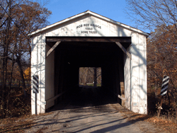
Rob Roy's covered bridge, now out of service | |
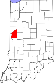 Fountain County's location in Indiana | |
 Rob Roy Rob Roy's location in Fountain County | |
| Coordinates: 40°14′12″N 87°14′36″W / 40.23667°N 87.24333°WCoordinates: 40°14′12″N 87°14′36″W / 40.23667°N 87.24333°W | |
| Country | United States |
| State | Indiana |
| County | Fountain |
| Township | Shawnee |
| Named for | Rob Roy |
| Elevation[1] | 659 ft (201 m) |
| ZIP code | 47918 |
| FIPS code | 18-65178[2] |
| GNIS feature ID | 449720 |
Rob Roy is an unincorporated community in Shawnee Township, Fountain County, Indiana.
History
The town of Rob Roy was named after the Scottish patriot Robert Roy MacGregor[3] by local John I. Foster, a lover of literature who was especially fond of Walter Scott's novels. Foster, described as an inventor and a worker of iron, lived in Rob Roy for six or seven years and founded a Methodist church there.
The town was platted circa 1826 and contained 48 lots, with a further addition on the east side by Hiram Jones in 1829. A writer in 1833 described Rob Roy as a small interior village with few inhabitants but increasing in improvement and population; by 1836 it had "five dry goods stores and four groceries, a hotel, three physicians, and was in the center of a very active settlement." The passage of the Chicago and Block Coal Railway through the town also stimulated growth, but competition with nearby Attica (which was on the Wabash and Erie Canal) eventually led to Rob Roy's demise.[4][5]
The post office in Rob Roy was established in 1832, and discontinued in 1906.[6]
Rob Roy was heavily damaged by a tornado in April 1953.[7] Today the town consists of a small gathering of homes.
Geography
Rob Roy is located at 40°14′12″N 87°14′36″W / 40.23667°N 87.24333°W, approximately 3 miles (4.8 km) south of Attica along U.S. Route 41. Big Shawnee Creek, spanned by a covered bridge, snakes along the north side of town and Little Shawnee Creek flows along the south. The confluence of the two is half a mile to the west.
References
- ↑ "US Board on Geographic Names". United States Geological Survey. 2007-10-25. Retrieved 2008-01-31.
- ↑ "American FactFinder". United States Census Bureau. Retrieved 2008-01-31.
- ↑ Baker, Ronald L. (October 1995). From Needmore to Prosperity: Hoosier Place Names in Folklore and History. Indiana University Press. p. 283. ISBN 978-0-253-32866-3.
..named for the Scottish outlaw Rob Roy...
- ↑ Beckwith, H. W. (1881). "Shawnee Township". History of Fountain County. Chicago: H. H. Hill and N. Iddings. pp. 342–343.
- ↑ Thomas A. Clifton, ed. (1913). Past and Present of Fountain and Warren Counties, Indiana. Indianapolis: B. F. Bowen & Co. p. 168.
- ↑ "Fountain County". Jim Forte Postal History. Retrieved 7 September 2014.
- ↑ "Midwest Tornadoes Leave Three Dead". Rome News-Tribune. Rome, Georgia. April 10, 1953.
Municipalities and communities of Fountain County, Indiana, United States | ||
|---|---|---|
| Cities | ||
| Towns | ||
| Townships | ||
| Unincorporated communities | ||