River Alport
| Alport | |
| River | |
 | |
| Country | England |
|---|---|
| Region | Derbyshire |
| Source | |
| - location | Bleaklow, England |
| Length | 9 km (6 mi) |
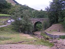
The River Alport flows for 9 km in the Dark Peak of the Peak District in Derbyshire, England. Its source is on Bleaklow, from which it flows south through the Grains in the Water swamp, then over gritstone to Alport Bridge on the A57 Snake Pass route from Sheffield to Manchester, where it joins the River Ashop, which flows into the Ladybower Reservoir about 2.5 miles (4.0 km) down the valley.
The course of the river includes three small waterfalls. At its southern end lie the remains of a tunnel constructed to carry water to a planned but unbuilt cotton mill. A weir was built on the river in about 1922 and a short watercourse added to feed the water into the Ashop weir located upstream of the confluence. The water was then culverted along the valley to the Ashop Siphon near Hagg Farm, where it then crossed over the River Ashop in a 6-foot-diameter (1.8 m) steel pipe 273 yards (250 m) long, passed through a 1,065-yard (974 m) tunnel under the hill and then via another open watercourse of 761 yards (696 m) to discharge into the Derwent Reservoir a few yards north of the dam wall. The outlet is visible from the viewing area.[1]
The valley of the Alport contains some farmland, but the banks of the valley are mostly coniferous plantations and heath. The coniferous plantations are being converted to semi-natural deciduous woodland.[2] The small hamlet of Alport lies on the west bank near the southern end of the river. On the eastern bank lies the Alport Castles landslide.
References
- Roger Redfern, Walking in Peakland
- ↑ Walls agross the Valley, The building of the Howden and Derwent Dams, by Brian Robinson, pub by Scarfin Books, ISBN 0-907758-57-6
- ↑ Archived March 11, 2007, at the Wayback Machine.
| Unitary authorities | |
|---|---|
| Boroughs or districts | |
| Major settlements |
|
| Rivers | |
| Topics | |
Coordinates: 53°24′N 1°47′W / 53.400°N 1.783°W