Chapel-en-le-Frith
| Chapel-en-le-Frith | |
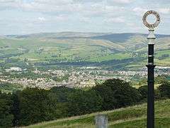 View of the town from Cowlow Lane |
|
 Chapel-en-le-Frith parish highlighted within Derbyshire |
|
| Population | 8,635 (Parish, 2011)[1] |
|---|---|
| OS grid reference | SK055806 |
| Civil parish | Chapel-en-le-Frith |
| District | High Peak |
| Shire county | Derbyshire |
| Region | East Midlands |
| Country | England |
| Sovereign state | United Kingdom |
| Post town | HIGH PEAK |
| Postcode district | SK23 |
| Dialling code | 01298 |
| Police | Derbyshire |
| Fire | Derbyshire |
| Ambulance | East Midlands |
| EU Parliament | East Midlands |
| UK Parliament | High Peak |
|
|
Chapel-en-le-Frith /ˌtʃæpəl ˌɒn lə ˈfrɪθ/ is a small town and civil parish in Derbyshire, England. Dubbed "The Capital of the Peak District", parts of the parish lie within the Peak District National Park, though the town itself is outside the Park boundary. The settlement was established by the Normans in the 12th century, originally as a hunting lodge within the Forest of High Peak. This led to the French-derived name of Chapel-en-le-Frith ("Chapel in the forest").[2] The population of 'Chapel', as locals commonly refer to it, was 8,635 in the 2011 census. For some years Chapel was the location of the High Peak Borough Council offices. The settlement has several public houses, hotels and guesthouses, a tearoom, a golf club, a cricket club and a football club.
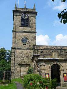
Church of St Thomas Becket
The first chapel in the town (now the Church of St. Thomas Becket) was originally built by the Normans but was replaced with a larger building a hundred years later. It stands at the highest point in the town proper. The current building is now almost entirely of 18th century construction above a crypt of 1225 AD. Buried in the churchyard are soldiers of the Scottish army of the Duke of Hamilton who marched south in support of Charles I in 1648. After their defeat at Preston, they were marched to Chapel and imprisoned in the church for sixteen days in such squalid conditions that forty died; a further ten died when they were marched towards Cheshire. The Eccles Pike Cross stands in the churchyard, having been moved here from Ollerenshaw Farm in 1925. It is believed to be Anglo-Saxon and is covered in very worn carvings.[3]

Industry
There is a certain amount of industry – especially behind the church in the lowest part of the town, where the brake-lining manufacturer Ferodo (an anagram of Frood, the 19th-century founder's name, with the addition of a letter "e") was a family concern for over a hundred years; it is now part of the international conglomerate Federal-Mogul.
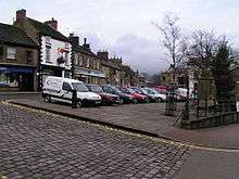
There is a regular market place, cobbled and raised above the High Street, which is still used every Thursday to host the local market (though due to the current economic climate the number of stalls present has declined considerably). A market cross has a faint date which may read 1636, but the cross itself is considerably older.[3]
Institutions
Chapel Poor Law Union was established in December 1837. The union workhouse was built c.1840 on the Whaley Bridge road (grid reference SK051805). It consisted of an entrance range and an accommodation block of three wings centred on an octagonal hub, an infirmary and an isolation hospital. The workhouse was later converted to an old people's home, and was demolished in the early 1980s.[4]
High Peak Radio, Independent Local Radio for High Peak and the Hope Valley, broadcasts from studios just off the High Street.
Just outside the town lies The Chestnut Centre. Established in the early 1980s and open to the public, it houses a large collection of otters, owls and native wildlife.[5]
Transport
Chapel-en-le-Frith railway station is located 1.5 km (ca. 1 mile) from the town centre, on the commuter line from Buxton to Manchester Piccadilly. The other railway line passing through the town, which has a more central disused station[n 1] built by the Midland Railway, was once one of the main lines from London to Manchester. While it no longer carries passenger traffic, it now carries a constant stream of roadstone from the quarries around Buxton. It terminates at its junction with the Manchester–Sheffield trans-Pennine line by way of two viaducts, diverging east and west, above the Black Brook valley at Chapel Milton near Chinley signalbox.

_station_geograph-3300512-by-Ben-Brooksbank.jpg)
Sport
The town's football team is Chapel Town F.C. that play in the Manchester Football League Division One.[6]
Moorlands
To the north lie the Dark Peak highlands, which are made up of millstone grit and are heather-covered, rugged and bleak. Here are Chinley Churn and South Head with, a little further off, Kinder Scout, which looms above the whole area. To the south is the gentler and more pastoral White Peak, consisting largely of limestone grasslands, nevertheless with spectacular bluffs and the occasional gorge. Combs Moss, a gritstone 'edge', dominates the valley in which Chapel lies from the south and Eccles Pike rises sharply above the town to its west and provides a commanding 360° viewpoint.
Education
There are two schools in the town: Chapel-en-le-Frith High School and Chapel-en-le-Frith Primary School.
TV
Scenes from the BBC TV series The Village[7] and The Secret of Crickley Hall were filmed in and around Chapel; Bowden Hall featured in both series.
Historical figures and landmarks of the parish

South Head in the background
Ford Hall in the east of the parish, northeast of Slacke Hall and Bowden Hall, was the home of the Reverend William Bagshaw, the 'Apostle of the Peak', after he was ejected from the vicarage of Chinley on the Act of Uniformity in 1662.[8]
Also in the east of the parish, next to a lake alongside the A623 and not nationally listed for its architecture, is the modest Bennetston Hall, which is being renovated as a hotel. Nearby are the site of Peaslow's Cross, and Rushup Hall, a modest but ornate 19th-century private house.[9]
Stodhart Lodge, a care home, is north of the town centre on the Hayfield Road, the old road to Chapel Milton and the rest of the neighbouring parish of Chinley. It has a later 19th-century extension in the neo-gothic architectural style with a datestone inscribed "JB 1869".[10]
Along the B5470 road west of the town are the linear settlements of Bridgefields, Cockyard and Tunstead Milton. Ollerenshaw Hall dates from c.1800[11] and stands below Eccles Pike.
Combs
The village of Combs, west of the town, gives its name to the adjacent Combs Reservoir. The Old Brook House (and its barn), close to the Beehive Inn in the centre of Combs, are listed buildings;[12][13] parts of the house's grand layout clearly date from the 17th and 18th centuries and, as such, it is similar to Marsh Hall closer to Chapel.[14]
In the rolling hills between Combs and Chapel is Bank Hall, extensively altered in 1872–74 for Henry Renshaw of Manchester on an ornate aerial plan with an elaborate stone balcony over the door, a bay window with fine botanical painted glass and canvas panels to the doors, formerly with painted panels by Armstrong and Caldecott. The south elevation of the house has a central Venetian doorway with columns either side of double-glazed doors—here too are voussoirs decorated with floral motifs, set in an imposing ashlar surround.[15] Its nearby lodge, by W.E.Nesfield, is also listed,[16] as is nearby Chapel railway station.[17]
Dove Holes
Dove Holes, in the southeast of the parish, has its own station. Within the village lie the earthworks of a Neolithic henge known as the Bull Ring; the site also includes an oval and bowl barrow.[18]
Neighbouring settlements and landmarks
 |
New Mills, Chinley | Glossop, Hayfield | Kinder Scout, Edale | |
| Whaley Bridge | |
Sparrowpit, Bradwell | ||
| ||||
| | ||||
| Combs, Errwood Reservoir, Shining Tor | Dove Holes, Buxton | Tideswell, Bakewell |
Notes and references
- Notes
- References
- ↑ "Neighbourhood Statistics". Office for National Statistics. Retrieved 18 October 2014.
- ↑ "A Brief History of the Parish". Chapel-en-le-Frith Parish Council. Retrieved 18 March 2013.
- 1 2 Sharpe, Neville T. (2002). Crosses of the Peak District. Landmark Collectors Library.
- ↑ Higginbotham, P (2007). Workhouses of the Midlands. Stroud: Tempus. p. 27. ISBN 978-0-7524-4488-8.
- ↑ "Home page". Chestnut Centre. Retrieved 26 February 2014.
- ↑ "Homepage | CHAPEL TOWN FC". www.clubwebsite.co.uk. Retrieved 4 November 2016.
- ↑ "New BBC TV drama The Village set in Derbyshire's Peak District". Derby Telegraph. 31 March 2013. Retrieved 4 November 2016.
- ↑ Historic England. "Ford Hall (Grade II) (1088059)". National Heritage List for England. Retrieved 18 March 2013. – its Coach House, Garden House and Bridge are all separately listed.
- ↑ Historic England. "Rushup Hall (Grade II) (1088026)". National Heritage List for England. Retrieved 18 March 2013.
- ↑ Historic England. "Stodhart Lodge (Grade II) (1298848)". National Heritage List for England. Retrieved 18 March 2013.
- ↑ Historic England. "Ollerenshaw Hall (Grade II) (1088052)". National Heritage List for England. Retrieved 18 March 2013.
- ↑ Historic England. "Old Brook House (Grade II) (1263667)". National Heritage List for England. Retrieved 18 March 2013.
- ↑ Historic England. "Barn at Brook House Farm (Grade II) (352022)". National Heritage List for England. Retrieved 18 March 2013.
- ↑ Historic England. "Marsh Hall and Barn (Grade II) (1088025)". National Heritage List for England. Retrieved 18 March 2013.
- ↑ Historic England. "Bank Hall (Grade II) (1263667)". National Heritage List for England. Retrieved 18 March 2013.
- ↑ Historic England. "Bank Hall Lodge (Grade II) (1088046)". National Heritage List for England. Retrieved 18 March 2013.
- ↑ Historic England. "Chapel-en-le-Frith Station (Grade II) (1334789)". National Heritage List for England. Retrieved 18 March 2013.
- ↑ Bull Ring Henge – Scheduled Ancient Monument Historic England. "Bull Ring henge, oval barrow and bowl barrow (1011204)". National Heritage List for England. Retrieved 18 March 2013.
External links
 "Chapel-en-le-Frith". Encyclopædia Britannica. 5 (11th ed.). 1911.
- Chapel-en-le-Frith Parish Council
- Chapel-en-le-Frith.com website
Coordinates: 53°19′19″N 1°55′01″W / 53.322°N 1.917°W