Rigolets
| Rigolets | |
| Tidal strait | |
 19th-century Rigolets lighthouse in 2004. It was destroyed by Hurricane Katrina in 2005. | |
| Country | United States |
|---|---|
| State | Louisiana |
| Tributaries | |
| - left | Old Pearl River |
| - right | Sawmill Pass |
| Source | Lake Pontchartrain |
| - coordinates | 30°10′40″N 89°44′40″W / 30.177778°N 89.744444°W |
| Mouth | Lake Borgne |
| - coordinates | 30°09′16″N 89°37′31″W / 30.154444°N 89.625278°WCoordinates: 30°09′16″N 89°37′31″W / 30.154444°N 89.625278°W |
| Length | 8 mi (13 km) |
 U.S. Geological Survey map 1982 | |
| Wikimedia Commons: The Rigolets | |
The Rigolets is a 12.9 kilometer (8 mi) long strait in Louisiana. "Rigolets" comes from the word rigole, French for "trench" or "gutter." The name is now locally pronounced "RIG-uh-leez." It begins at 30°10′40″N 89°44′40″W / 30.17778°N 89.74444°W and follows a generally eastward course to Lake Borgne, a lagoon in the Gulf of Mexico, and finally to the Gulf of Mexico, where it ends at 30°09′16″N 89°37′31″W / 30.15444°N 89.62528°W. Along with nearby Chef Menteur Pass, the Rigolets connects Lake Pontchartrain and Lake St. Catherine to Lake Borgne, and then to the Gulf of Mexico.[1][2] It forms the boundary between New Orleans (Orleans Parish) and St. Tammany Parish.
Tidal pass
As a deepwater tidal pass, the Rigolets helps supply salt water from the Gulf to Lake Pontchartrain.[3] Tidal scouring has produced a deep pit in the lake at the western mouth of the strait.[4] Since the Rigolets is a channel through which Gulf storm surges can approach the New Orleans area, there are proposals to construct floodgates.[5]
Fort Pike
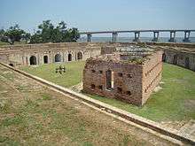
The United States constructed Fort Pike following the War of 1812 to protect passage on the Rigolets.[6] The fort was abandoned in 1890.
Bridges
The Rigolets is spanned by two bridges. The western terminus of the U.S. Route 90 Rigolets Bridge is located immediately north of Fort Pike. It was damaged by Hurricane Katrina in August 2005, which required major repairs.[7] Farther south, the CSX Railroad crosses the Rigolets on a 1,388-meter (4,555-ft) railroad bridge.[8] Hurricane damage there included shifted spans and the loss of timber decking.[9]
References
- ↑ "The Rigolets". USGS Geographic Names Information System. Retrieved 2006-04-17.
- ↑ "Comprehensive Habitat Management Plan for the Lake Pontchartrain Basin" (PDF). Lake Pontchartrain Basin Foundation. 2005-11-18. Retrieved 2006-04-15.
- ↑ "Martello Castle Background Information". Wetland Education through Maps and Aerial Photography. Retrieved 2006-04-17.
- ↑ "Basin Geology". Environmental Atlas of the Lake Pontchartrain Basin. Retrieved 2006-04-17.
- ↑ "Full flood safety in New Orleans could take billions and decades". Louisiana Dept. of Natural Resources. Retrieved 2006-04-17.
- ↑ Louisiana Department of Culture, Recreation and Tourism. "Fort Pike Historical Marker".
- ↑ "DOTD inspects movable bridges in hurricane-affected area" (Press release). Louisiana Dept. of Transportation & Development. 2005-09-07.
- ↑ Judge, Tom. "Bridging to recovery". Railway Age. Retrieved 2006-04-15.
- ↑ "Restoring Katrina-ravaged bridges". Railway Track and Structures. Archived from the original on March 14, 2006. Retrieved 2006-04-15.