London Borough of Bromley
| London Borough of Bromley | |||
|---|---|---|---|
| London borough | |||
| |||
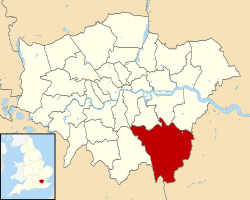 Bromley shown within Greater London | |||
| Sovereign state | United Kingdom | ||
| Constituent country | England | ||
| Region | London | ||
| Ceremonial county | Greater London | ||
| Status | London borough | ||
| Admin HQ | Stockwell Close, Bromley | ||
| Created | 1 April 1965 | ||
| Government | |||
| • Type | London borough council | ||
| • Body | Bromley London Borough Council | ||
| • Leadership | Leader (Cllr Stephen Carr) & Cabinet (Conservative) | ||
| • Mayor | Cllr Julian Bennington | ||
| • MPs |
Jo Johnson Bob Stewart Bob Neill Jim Dowd | ||
| • London Assembly | Gareth Bacon AM for Bexley and Bromley | ||
| • EU Parliament | London | ||
| Area | |||
| • Total | 57.97 sq mi (150.15 km2) | ||
| Area rank | 188th (of 326) | ||
| Population (mid-2014 est.) | |||
| • Total | 321,278 | ||
| • Rank | 23rd (of 326) | ||
| • Density | 5,500/sq mi (2,100/km2) | ||
| • Ethnicity[1] |
77.4% White British | ||
| • ONS code | 00AF | ||
| Time zone | GMT (UTC0) | ||
| • Summer (DST) | BST (UTC+1) | ||
| Postcodes | BR, CR, DA, SE, TN | ||
| Area code(s) | 01689, 01959, 020 | ||
| Police force | Metropolitan Police | ||
| Website |
www | ||


The London Borough of Bromley ![]() i/ˈbrɒmli/ is one of the 32 London Boroughs (plus the City) which make up Greater London. The London Borough of Bromley is south of the River Thames which flows through London, the capital city of the United Kingdom. Bromley is the principal town in the London Borough of Bromley. Douglas Patterson is the Chief Executive Officer of the local authority, Bromley London Borough Council.
i/ˈbrɒmli/ is one of the 32 London Boroughs (plus the City) which make up Greater London. The London Borough of Bromley is south of the River Thames which flows through London, the capital city of the United Kingdom. Bromley is the principal town in the London Borough of Bromley. Douglas Patterson is the Chief Executive Officer of the local authority, Bromley London Borough Council.
Geography
The borough is the largest in Greater London by area and occupies 59 square miles (153 km2), of which the majority is Metropolitan Green Belt land. It is also perhaps the most rural.
Most of the population lives in the north and west of the borough, with an outlier at Biggin Hill in the far south. The borough shares borders with the London Boroughs of Lewisham and Greenwich to the North, Bexley to the North East, Southwark and Lambeth to the North West, as well as Croydon to the West. It also borders the Sevenoaks District of Kent to the East and South, and the Tandridge District of Surrey to the South West.
Westerham Heights, the highest point in London at an altitude of 804 feet (245 m), is located on the southern boundary. The Prime Meridian passes through Bromley.
About 30% of the land in Bromley is farmland, the highest figure of a London Borough.[2]
History
The borough was formed, as were all other London boroughs, on 1 April 1965 by the London Government Act 1963. It comprised the former area of the Municipal Borough of Bromley, the Municipal Borough of Beckenham, Penge Urban District, Orpington Urban District and the Chislehurst part of Chislehurst and Sidcup Urban District, which was transferred from Kent to Greater London.
In 1969, after a local campaign, the village of Knockholt was transferred back to Kent to become part of the Sevenoaks Rural District and later Sevenoaks District. Before 1965 it had been part of the Orpington Urban District.
Districts
The borough is partly urban and partly rural, the former to the north and very much part of the built-up area of suburban London.
The principal parts of the northern section, from west to east, are Beckenham, which includes Eden Park and Elmers End; Bromley with Bickley, Bromley Park and Bromley Common, Park Langley, Plaistow, Shortlands, and Southborough; Chislehurst, with Elmstead and Sundridge. The built-up area around Orpington not only encompasses its direct outskirts of Chelsfield, Crofton, Derry Downs, Goddington, Kevingtown, and Petts Wood; it also includes the erstwhile separate settlements of Farnborough, Green Street Green, Pratts Bottom, St Mary Cray and St Paul's Cray. Other smaller suburban areas include Anerley and nearby Crystal Palace; and Penge. In addition, parts of Mottingham, Sydenham, Swanley and Ruxley lie within the borough boundaries.
There are two main built-up areas in the southern part of the borough: Hayes and West Wickham. Biggin Hill, Downe and Keston with Leaves Green and Nash are separate, smaller, rural settlements.
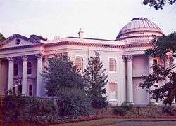
Local attractions include Down House (the home of Charles Darwin), Chislehurst Caves, Holwood House (the home of William Pitt the Younger), Crofton Roman Villa, and the site of The Crystal Palace.
Governance

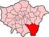
Bromley is divided into 22 wards with a total of 60 council seats. These are currently represented by:[3]
- Conservative: 51
- Labour: 7
- UKIP: 2
Bromley was under Conservative control from its creation until the local elections of 7 May 1998 when a Liberal Democrat/Labour coalition assumed power. After a number of by-elections and a defection, the Conservatives regained control on 5 July 2001.
The 22 wards are shown on the accompanying map. Ward names often straddle the named settlements and suburban areas above: their boundaries are fixed, whereas the latter are not.
Demographics
| Population | ||
|---|---|---|
| Year | Pop. | ±% |
| 1801 | 8,944 | — |
| 1811 | 10,186 | +13.9% |
| 1821 | 11,455 | +12.5% |
| 1831 | 13,302 | +16.1% |
| 1841 | 14,878 | +11.8% |
| 1851 | 17,192 | +15.6% |
| 1861 | 33,144 | +92.8% |
| 1871 | 49,095 | +48.1% |
| 1881 | 65,046 | +32.5% |
| 1891 | 84,729 | +30.3% |
| 1901 | 99,502 | +17.4% |
| 1911 | 116,851 | +17.4% |
| 1921 | 140,960 | +20.6% |
| 1931 | 170,073 | +20.7% |
| 1941 | 216,821 | +27.5% |
| 1951 | 276,438 | +27.5% |
| 1961 | 290,065 | +4.9% |
| 1971 | 304,414 | +4.9% |
| 1981 | 294,547 | −3.2% |
| 1991 | 294,723 | +0.1% |
| 2001 | 295,560 | +0.3% |
| 2011 | 309,392 | +4.7% |
| Source: A Vision of Britain through time | ||
In 1801, the civil parishes that form the modern borough had a total population of 8,944. This rose slowly throughout the 19th century, as the district became built up; reaching 17,192 in the middle of the century. When the railways arrived the rate of population growth increased. The population peaked in the 1970s, when industry began to relocate from London.
In the 2011 Census, the borough had a population of 309,392. All major religions are represented, but of those stating a choice, 60.07% described themselves as Christian. In 2001, of the population, 43.47% were in full-time employment and 11.06% in part-time employment – compared to a London average of 42.64% and 8.62%, respectively. Residents were predominantly owner-occupiers, with 32.53% owning their house outright, and a further 42.73% owning with a mortgage. Only 1.42% were in local authority housing, with a further 12.74% renting from a housing association, or other registered social landlord.[4]
Education
Transport
Bromley is one of only six London Boroughs[5] not to have at least one London Underground station within its boundaries. However, the borough has many railway stations served by London Overground, Thameslink, Southeastern and Southern. The borough also has several stops on the London Tramlink network. It was also reported that Boris Johnson plans to introduce either an extension of the Bakerloo Line to Hayes, in Bromley, passing through Beckenham Junction, or an extension of the DLR to Bromley North. One last option is the extension of the London Overground to Bromley North. The most likely is the extension of the Bakerloo Line, but would not be scheduled to begin till 2040, if accepted.
National Rail stations:
- Crystal Palace
- Birkbeck
- Beckenham Junction
- Shortlands
- Bromley North
- Bromley South
- St Mary Cray
- Sundridge Park
- Ravensbourne
- Bickley
- Elmstead Woods
- Chislehurst
- Petts Wood
- Orpington
- Chelsfield
- Knockholt
- Kent House
- Penge East
- Penge West
- Anerley
- Lower Sydenham (Shared with Lewisham)
- New Beckenham
- Clock House
- Elmers End
- Eden Park
- West Wickham
- Hayes
Tramlink stops:
In March 2011, the main forms of transport that residents used to travel to work were: driving a car or van, 27.4% of all residents aged 16–74; train, 5.1%; bus, minibus or coach, 5.1%; on foot, 4.3%; work mainly at or from home, 4.0%; underground, metro, light rail, tram, 2.3%; passenger in a car or van, 1.5%.[6]
Sport, leisure and culture
The Borough has several sporting clubs:
- Bromley F.C. a Non-League football club
- Cray Wanderers F.C. a Non-League football club
- Orpington F.C. a Non-League football club
- Holmesdale F.C. a Non-League football club
- Greenwich Borough F.C. a Non-League football club
- Beckenham Town F.C. a Non-League football club
- Club Langley FC a Non-League football club
The borough is also home to an extensive libraries service, containing 14 branches that are all part of the wider London Libraries Consortium.
Crime
Crime rates in Bromley are generally higher than the national average, but it is considered one of the safest London boroughs.[7]
Crime rates in Bromley (per 1000 population)
| Offence | Locally | Nationally |
| Robbery | 3.01 | 1.85 |
| Theft of a motor vehicle | 5.20 | 4.04 |
| Theft from a motor vehicle | 10.99 | 9.59 |
| Sexual offences | 0.98 | 1.17 |
| Violence against a person | 18.38 | 19.97 |
| Burglary | 7.06 | 5.67 |
London Fire Brigade
London Fire Brigade has four fire stations within the London Borough of Bromley. The borough is the largest in the city: about 150 km2. With just one pumping appliance, Orpington has one of the largest areas to cover in London, measuring 46.7 km2. In 2006/2007, Orpington attended 1,308 incidents. There is also a high volume pump at the station. Beckenham, Bromley and Biggin Hill cover the rest of the borough with four pumping appliances and a hose layer.[8]
In 2006/2007 just under 4000 incidents were attended in the borough. Noticeably, compared to 2005/2006 there was an 11% decrease in special service calls (road traffic collisions, chemical incidents, flooding etc.).[9]
Twin Towns
Bromley is twinned with:
 Neuwied, Rhineland-Palatinate, Germany.
See also
References
- ↑ 2011 Census: Ethnic group, local authorities in England and Wales, Office for National Statistics (2012). See Classification of ethnicity in the United Kingdom for the full descriptions used in the 2011 Census.
- ↑ http://www.capitalgrowth.org/big_idea/facts_figures/
- ↑ "Elections 2014 - Local Council Elections - Results 2014". London Borough of Bromley website. London Borough of Bromley. Retrieved 26 January 2016.
- ↑ Key Figures for 2001 Census: Census Area Statistics: Bromley accessed 25 February 2009
- ↑ Six London boroughs (Bexley, Bromley, Croydon, Kingston, Lewisham and Sutton) are not served by the Underground. The London Borough of Hackney has two stations on its border.
- ↑ "2011 Census: QS701EW Method of travel to work, local authorities in England and Wales". Office for National Statistics. Retrieved 23 November 2013. Percentages are of all residents aged 16-74 including those not in employment. Respondents could only pick one mode, specified as the journey’s longest part by distance.
- ↑ "Bromley crime statistics". FindaProperty.com. June 2005.
- ↑ http://www.london-fire.gov.uk/about_us/media/Bromley.pdf London Fire Brigade - Bromley Profile
- ↑ London Fire Brigade - Bromley Profile
External links
- Summary of formation of the Borough, including its constituent parts
- London Borough of Bromley council website
- London Borough of Bromley Museum
- Bromley mytime - local sports facilities
- Council for Voluntary Service for the London Borough of Bromley
- Directory of local services
- Images of Bromley
- Bromley Neighbourhood Watch Association website (BromleyNWA.org.uk)
Coordinates: 51°20′N 0°05′E / 51.333°N 0.083°E