Riddle's Station
|
Riddle's Station Site | |
 | |
 | |
| Nearest city | Wilburton, Oklahoma |
|---|---|
| Coordinates | 34°55′13.9″N 95°15′24.13″W / 34.920528°N 95.2567028°WCoordinates: 34°55′13.9″N 95°15′24.13″W / 34.920528°N 95.2567028°W |
| Built | 1858 |
| NRHP Reference # | 72001072 [1] |
| Added to NRHP | June 13, 1972 |
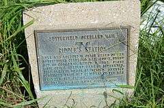
Riddle's Station was a stage stand on the old Butterfield Overland Mail route in Indian Territory. It was located on the west side of the Forche Maline in what is now Latimer County. The station was named for Captain John Riddle, the operator. Riddle was a mixed-blood Choctaw and a prominent member of the Nation. He served many terms on the Choctaw Council. In 1858, the Council granted Riddle the right to build a bridge and tollbooth across the Forche Maline near his station.
Riddle's Station was added to the National Register of Historic Places in 1972.
Notes
- ↑ National Park Service (2007-01-23). "National Register Information System". National Register of Historic Places. National Park Service.
Sources
- Shirk, George H. Oklahoma Place Names. Norman: University of Oklahoma Press, 1987: ISBN 0-8061-2028-2 .
- Wright, Murial H.; George H. Shirk; Kenny A. Franks. Mark of Heritage. Oklahoma City: Oklahoma Historical Society, 1976.
- Wright, Muriel H. "The Butterfield Overland Mail One Hundred Years Ago", Chronicles of Oklahoma 35:1 (January 1957) 55-71 (accessed August 23, 2006).
| Butterfield Overland Mail in Indian Territory | ||||
| Next station West Pusley's Station |
16 miles |
Riddle's Station | 18 miles |
Next station East Holloway's Station |
| Topics | |
|---|---|
| Lists by states |
|
| Lists by insular areas | |
| Lists by associated states | |
| Other areas | |
| |
This article is issued from Wikipedia - version of the 11/25/2016. The text is available under the Creative Commons Attribution/Share Alike but additional terms may apply for the media files.