Richecourt
| Richecourt | |
|---|---|
 Richecourt | |
|
Location within Grand Est region  Richecourt | |
| Coordinates: 48°52′50″N 5°45′43″E / 48.8806°N 5.7619°ECoordinates: 48°52′50″N 5°45′43″E / 48.8806°N 5.7619°E | |
| Country | France |
| Region | Grand Est |
| Department | Meuse |
| Arrondissement | Arrondissement of Commercy |
| Canton | Canton of Saint-Mihiel |
| Intercommunality | Communauté de communes de la Petite Woëvre |
| Government | |
| • Mayor (2008–2014) | Daniel Rouyer |
| Area1 | 6.23 km2 (2.41 sq mi) |
| Population (1999)2 | 43 |
| • Density | 6.9/km2 (18/sq mi) |
| Time zone | CET (UTC+1) |
| • Summer (DST) | CEST (UTC+2) |
| INSEE/Postal code | 55431 / 55300 |
| Elevation |
223–243 m (732–797 ft) (avg. 239 m or 784 ft) |
|
1 French Land Register data, which excludes lakes, ponds, glaciers > 1 km² (0.386 sq mi or 247 acres) and river estuaries. 2 Population without double counting: residents of multiple communes (e.g., students and military personnel) only counted once. | |
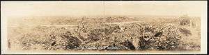
World War I damage at Richecourt
Richecourt is a commune in the Meuse department in Grand Est in north-eastern France.
Geography
The village lies on the left bank of the Rupt de Mad, which flows northeastward through the south-eastern part of the commune.
See also
| Wikimedia Commons has media related to Richecourt (Meuse). |
This article is issued from Wikipedia - version of the 11/6/2016. The text is available under the Creative Commons Attribution/Share Alike but additional terms may apply for the media files.