Richardson, Australian Capital Territory
| Richardson Canberra, Australian Capital Territory | |||||||||||||
|---|---|---|---|---|---|---|---|---|---|---|---|---|---|
 | |||||||||||||
| Coordinates | 35°25′34″S 149°06′54″E / 35.426°S 149.115°ECoordinates: 35°25′34″S 149°06′54″E / 35.426°S 149.115°E | ||||||||||||
| Population | 3,133 (2011 census)[1] | ||||||||||||
| • Density | 1,420/km2 (3,690/sq mi) | ||||||||||||
| Established | 1981 | ||||||||||||
| Gazetted | 5 May 1975 | ||||||||||||
| Postcode(s) | 2905 | ||||||||||||
| Area | 2.2 km2 (0.8 sq mi) | ||||||||||||
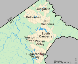
| District | Tuggeranong | ||||||||||||
| Territory electorate(s) | Brindabella | ||||||||||||
| Federal Division(s) | Canberra | ||||||||||||
| |||||||||||||
Richardson is a suburb in the Canberra, Australia, district of Tuggeranong. The postcode is 2905. The suburb is named after the author Henry Handel Richardson, nom de plume of Ethel Florence Lindesay Richardson (1870–1946).[2] It was gazetted on 5 May 1975.[2] Streets are named after writers, especially female writers.[2] It is next to the suburbs of Calwell, Isabella Plains, Gowrie and Chisholm. It is bounded by Johnson Drive, Ashley Drive and Isabella Drive.
Demographics
On Census night 2011, Richardson had a population of 3,133 people. The median age of people in Richardson was 33 years, compared to a median age of 34 for the ACT. Unemployment in Richardson was 1.2% higher than the ACT average. The median weekly individual income for Richardson in 2011 was $781, compared to $917 for the ACT, while the median weekly household income was $1,632. In 2011 the median monthly housing loan repayment in Richardson was $1,869.[1]
The residents of Richardson are predominantly Australian born, with 77.8% being born in Australia. The three main countries of birth for those born overseas were England, 3.7%, New Zealand, 1.5% and India, 0.8%. The most popular religious affiliations in descending order are Catholic, no religion, Anglican and Uniting.[1]
Suburb amenities and places of interest
Richardson Primary school, located on May Gibbs Close, opened in 1984; the school has a major focus on information and communications technology in education. Richardson Primary School was the first school within Australia to install Interactive Whiteboards.[3] Richardson Preschool is also located on May Gibbs Close.[4]
The Tuggeranong Homestead heritage site is accessed off Johnson Drive and hosts the Tuggeranong Homestead markets on the first Sunday of each month. The Richardson local centre and Richardson Oval are located on May Gibbs Close. Richardson also has a scout hall on Clift Crescent.
Several ACTION bus routes service Richardson. Routes 65, 66 and 67 run between the Tuggeranong and Woden Interchanges every 20 to 60 minutes between 7:00 a.m. and 7:00 p.m. The additional services 265 and 267, following the same routes through Richardson as 65 and 67 respectively, run during peak hour from the Tuggeranong Interchange to City West.[5]
Politics
| |||||||||||||||||||||||||||||||||
Richardson is located within the federal electorate of Canberra, which is currently (2016) represented by Gai Brodtmann in the House of Representatives. In the ACT Legislative Assembly, Richardson is part of the electorate of Brindabella, which elects five members on the basis of proportional representation, currently three Liberal and two Labor.[8] Polling place statistics are shown to the right for the Richardson polling place at Richardson Primary School in the 2016 federal[6] and 2016 ACT[7] elections.
Geology
Quaternary alluvium covers the whole suburb. This would have formed by erosion of the surrounding Deakin Volcanics in Chisholm and the hills to the east. Deep underneath are volcanic rocks from the Silurian age at 414 Mya.[9]
References
- 1 2 3 Australian Bureau of Statistics (31 October 2012). "Richardson (State Suburb)". 2011 Census QuickStats. Retrieved 15 February 2014.
- 1 2 3 Canberra's suburb and street names : origins and meanings. Department of the Environment, Land and Planning. 1992. p. 102. ISBN 1-86331-128-9.
- ↑ "Our School". Richardson Primary School. Retrieved 17 February 2014.
- ↑ "Preschools (Public)". ACT Department of Education and Training. Retrieved 17 February 2014.
- ↑ ACTION Buses (2006) ACTION Buses. Retrieved 11 July 2006
- 1 2 "Federal Election 2016 - Polling Place Richardson". Australian Electoral Commission. 26 July 2016. Retrieved 26 November 2016.
- 1 2 "2016 Results for Brindabella Candidates at Richardson Polling Place". ACT Electoral Commission. 26 November 2016. Retrieved 26 November 2016.
- ↑ "Current members". ACT Legislative Assembly. Retrieved 13 November 2016.
- ↑ Henderson G A M and Matveev G, Geology of Canberra, Queanbeyan and Environs 1:50000 1980.