Banks, Australian Capital Territory
| Banks Canberra, Australian Capital Territory | |||||||||||||
|---|---|---|---|---|---|---|---|---|---|---|---|---|---|
 | |||||||||||||
| Population | 5,060 (2011 census)[1] | ||||||||||||
| • Density | 2,200/km2 (5,700/sq mi) | ||||||||||||
| Established | 1992 | ||||||||||||
| Gazetted | 12 March 1987 | ||||||||||||
| Postcode(s) | 2906 | ||||||||||||
| Area | 2.3 km2 (0.9 sq mi) | ||||||||||||
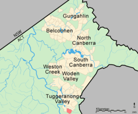
| District | Tuggeranong | ||||||||||||
| Territory electorate(s) | Brindabella | ||||||||||||
| Federal Division(s) | Canberra | ||||||||||||
| |||||||||||||
Banks is a suburb in the Canberra, Australia district of Tuggeranong. It is the most southerly suburb of Canberra. The suburb is named after Sir Joseph Banks (1743–1820), the botanist who accompanied Captain James Cook to Botany Bay in 1770.[2] The suburb was gazetted on 12 March 1987.[2] The theme of the street names is botany or natural history.[2]
Banks is located adjacent to the suburbs of Conder and Gordon. It is bounded by Box Hill Avenue, Tom Roberts Avenue and Tharwa Drive. Located in the suburb is Beau and Jessi Park and the Banks Oval.
The Rob Roy Nature Reserve, part of Canberra Nature Park, is a hilly region to the east of Banks that includes Mt Rob Roy. Nearer and also to the east of Banks is the smaller mountain Big Monks, accessible from Wollemi Place. Big Monks has a gliding stage near the top, allowing paragliders and hang-gliders to fly over the suburb of Banks. The suburb itself slopes gently to the west-northwest.
There is a small shopping centre in the suburb, on the main internal road, Pockett Avenue. It includes 2 small take-away food shops, a hair salon and a small IGA supermarket.

Geology
Alluvium is the surface geology for the whole suburb. Beneath the alluvium and making up the surrounding hills are the Deakin Volcanics, which erupted during the Silurian age 414 million years ago.[3]
See also
- "Place names search". Australian Government, Geoscience Australia. Archived from the original on 23 August 2008. Retrieved 4 August 2008.
References
| Wikimedia Commons has media related to Banks, Australian Capital Territory. |
- ↑ Australian Bureau of Statistics (31 October 2012). "Banks (State Suburb)". 2011 Census QuickStats. Retrieved 14 February 2014.
- 1 2 3 Canberra's suburb and street names : origins and meanings. Department of the Environment, Land and Planning. 1992. p. 1. ISBN 1-86331-128-9.
- ↑ Henderson G A M and Matveev G, Geology of Canberra, Queanbeyan and Environs 1:50000 1980.
Coordinates: 35°28′23″S 149°05′42″E / 35.473°S 149.095°E