Remuera
| Remuera, Auckland | |
|---|---|
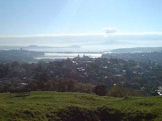
 View of Ōhinerau / Mount Hobson and Remuera | |
 Location of Remuera in Auckland City | |
| Basic information | |
| Local authority | Auckland Council |
| Population | 7,254 (2013) |
| Facilities | |
| Train station(s) | Remuera Train Station |
| Surrounds | |
| North | Hobson Bay, Waitematā Harbour |
| Northeast | Orākei |
| East | Meadowbank, St. Johns |
| Southeast | Mount Wellington |
| South | Ellerslie, |
| Southwest | Greenlane |
| West | Epsom, Newmarket |
| Northwest | Parnell |
Remuera is an affluent inner city residential suburban area within Auckland, in the North Island of New Zealand.[1] It is located four kilometres to the southeast of the city centre. Remuera is one of Auckland's older suburbs characterised by many large houses, often Edwardian or mid 20th century. A prime example of a "leafy" suburb, Remuera is noted for its quiet tree lined streets. The suburb has numerous green spaces, most obvious of which is Ōhinerau / Mount Hobson - a volcanic cone with views from the top overlooking Waitematā Harbour and Rangitoto.
According to the 2013 census, Remuera has a population of 7,254 people.[2] The suburb extends from Hobson Bay and the Orakei Basin on the Waitematā Harbour to the north and east, to the main thoroughfare of State Highway 1 in the southwest. It is surrounded by the suburbs of Orākei, Meadowbank, Saint Johns, Mount Wellington, Ellerslie, Greenlane, Epsom, Newmarket and Parnell. Remuera is home to many well-known New Zealanders including the late Sir Edmund Hillary and the famous race car driver Bruce McLaren.[3]
History
Remuera has had a long history of human occupation, starting back in the early 13th century when Māori came to the area.[4] The area was very attractive to Maori as much of the Auckland isthmus was devoid of trees and covered only in native flax, bracken and scrub. Remuera was different, having patches of woodland which were the habitat of many birds suitable for trapping while the adjacent harbour and basins were good fishing areas.
John Logan Campbell describes early 19th century Remuera in his book Poenamo:
Beautiful was Remuera's shore, sloping gently to Waitemata's sunlit waters in the days of which I write. The palm fern-tree was there with its crown of graceful bending fronds and black feathery-looking young shoots; and the karaka, with its brilliantly-polished green leaves and golden-yellow fruit, contrasting with the darker crimped and varnished leaf of the puriri, with its bright cherrylike berry. Evergreen shrubs grew on all sides, of every shade from palest to deepest green; lovely flowering creepers mounted high overhead, leaping from tree to tree and hanging in rich festoons; of beautiful ferns there was a profusion underfoot. The tui, with his grand rich note made the wood musical; the great fat stupid pigeon cooed down upon you almost within reach, nor took the trouble to fly away.— John Logan Campbell
The suburb is named after a pā on Ōhinerau / Mount Hobson, Remuwera.[5][6][7] Remu-wera literally translates to "burnt edge of kilt", commemorating the occasion where a chieftainess of Hauraki was allegedly captured and consumed.[8] Although the most common definition in reference literature, the accuracy of this definition has been described as "highly doubtful".[9]
Around 1741, Te Wai-o-Hua iwi was driven away by the Ngāti Whātua and Te Taoū iwi. Later, these iwi merged with Te Roroa and Te Uri-o-Hau into Ngāti Whātua-o-Ōrākei, which is the main iwi on the Tāmaki isthmus.[10] In May 1844 one of the largest Māori feasts ever held in New Zealand took place in Remuera. It was organised by the Waikato iwi and about 4000 Māori and many Pākehā were present. The festivities lasted for a week and large amounts of food and drinks were served: 11,000 baskets of potatoes, 9,000 sharks, 100 pigs, and large amounts of tea, tobacco and sugar. Governor Robert FitzRoy visited the festivities on 11 May 1844 when a haka was performed by 1,600 Māori, armed with guns and tomahawks.[11]
When the European settlers known as Pākehā wanted to buy the land on the Tāmaki isthmus from the Māori, they first declined. But in 1851, Henry Tacy Kemp, an interpreter to the Land Claims Commissioners, bought 700 acres for £5000. Subsequently, more plots of land were sold and put up for public auction. The land was suitable for pasture land and as the town of Auckland was some distance away people did not really start to build houses (as opposed to farmhouses) until the 1860s.[12] The ideal location included a view of the harbour. Many of the large villas stood on quite big properties, as their owners needed pasturing for carriage and riding horses and enjoyed creating landscape gardens. Some even had secondary houses for gardeners or estate managers. Many of these early houses still stand, surrounded now by later suburban developments or converted into institutions such as schools.
Smaller suburban houses began appearing in the area nearest Newmarket and began to spread along Remuera Road. The first shops opened in 1890 at the intersection with Victoria Avenue. Railway Stations at Newmarket and market Road encouraged the development of residents commuting to town. Likewise one of the most important routes for the Electric Tram System created in 1902 was to the Remuera Shops including an extension to the bottom of Victoria Avenue.
One of the first businesses was L.J. Keys’ grocery store on the Clonbern Rd corner, which currently houses a café.[13] Nowadays, Remuera's main business and shopping area stretches along Remuera Road from Armadale Road to St Vincent's Avenue. Smaller shopping areas are situated at Upland Road and Benson Road.
In 1915 Remuera was amalgamated into Auckland City. Up until that point it had been governed by the Remuera Road Board which had opposed joining Auckland in the face of campaigning by the Remuera Ratepayers Association. This included a Petition in 1912 in which 791 of the ratepayers (over 50%) signed to join with the adjacent Auckland City. A Commission of Enquiry was appointed, which recommended amalgamation. Again the Road Board declined and it was only after the Department of Internal Affairs intervened that the Road Board gave in. The union was ratified in February 1915 and the 2,520 acres of Remuera became part of Auckland. J.Dempsey said that Auckland had received "the brightest jewel in her crown today", although a subsequent Report by the City Engineer pointed out that Remuera had not been surveyed, it had 60 miles of primitive roading, and lacked proper stormwater drainage, sewerage and other services.
Auckland City Council embarked on a series of improvements for the new area. One of its first acts was to provide a free public library for the area in 1915, later replaced by the current building in 1926. In 1919 however local residents were incensed by the Council's building of public toilets at the Remuera shops that they demanded they be torn down. The first mile of Remuera Road was concreted in 1921 and the existing Tram line was doubled in 1924, followed by an extension of the service to Meadowbank.
In more recent history, the infamous Bassett Road machine gun murders took place in Remuera on 7 December 1963. Two men were shot with a .45 calibre Reising submachine gun at 115 Bassett Road and word quickly spread about a "Chicago-style" gang murder. Two suspects were sentenced to life imprisonment. One of them was paroled under strict conditions, but he disappeared in 1984 after his car was found at the bottom of a cliff. Initially the police suspected him to be faking his own death, but he was later declared to be officially dead. Several eyewitnesses claimed to have seen him in Perth, Australia in the late eighties or early nineties.[14]
Landmarks and features
Notable buildings and sites

Remuera has several places of historic interest, some of which have been incorporated into the Remuera Heritage Walk.[13]
- St Mark's Anglican Church. 1860s wooden Gothic church by Philip Herepath replacing an earlier structure from 1848 by Frederick Thatcher. Consecrated by Bishop Selwyn. The Rev John Kinder was minister here at a time when this was a rural parish. Scoriarock foundations.
- St Mark's Graveyard. The first burial was in 1849, and the last in 1963. The names of many well-known early Aucklanders appear here, including James Dilworth.
- Former Remuera Freemasons Hall, Remuera Road. Probably designed by the architect Henry G. Wade, the Hall was consecrated on 9 November 1880, at a ceremony presided over by the Deputy Grand Master of the Auckland Grand Lodge District (E.C.), William Lodder. The Remuera Masonic Hall survives as the oldest purpose-built lodge premises in the former Auckland Grand Lodge District (E.C.). Sold by the Freemasons in 1993.
- Saint Michael's Catholic Church, 6 Beatrice Road. A large Italian Romanesque style church designed by the noted architects Tole and Massey. Opened on 1 October 1933.
- St Luke's Presbyterian Church, Remuera Road. Masonry Gothic church from 1932 replacing an 1874 wooden building. Designed by Francis Drummond Stewart who also designed the Chateau Tongariro (1928). The present church was modeled on the parish kirk in the Scottish mining village of Twechar, built in 1902. Reinforced concrete and brick construction, with an external cladding of Putaruru stone. The foundation stone was laid in 1931 by Miss Sarah Dingwall.
- King's School, 258 Remuera Road. King's College started in 1896 occupying the house called "The Tower", built for David Graham, brother of the founder of Ellerslie, Robert Graham.
- 4 Garden Road. Garden Road was originally the driveway to Number 4, a house designed by prominent architect C. Reginald Ford (of the firm Gummer and Ford)as his own residence. Built in an eclectic architectural mix with French and Italian influences, number 4 later became the "Remuera Ladies College" whose students included Jean Batten.
- Skeltons Building 1928, 339-345 Remuera Road. Built for Robert Skelton, a carrier and one of Remuera’s first businessmen. This set of shops retain their original tiled shopfronts.
- Hellaby Building 1926, 357-365 Remuera Road was built for Frederick Hellaby whose family ran a chain of Butcher's shops.
- Remuera Pharmacy, 375-377 Remuera Road. 1909 building for a business operated by Fred Blott.
- Cole’s Building, 382-394 Remuera Road. 1923 building; the first tenant was Wylies Pharmacy.
- L.J. Keys’ grocery store. Corner of Clonbern Road - this was the first shop in the area (1907).
- Former Remuera Post Office, cnr Victoria Ave and Remuera Road. Built in 1914 to the designs of the Government Architect John Campbell.
- Brick shops 1929. 411-413 Remuera Road. These two-storey shops replaced the wooden building constructed in 1902 as the Remuera Road Board office, which later became the first Remuera Public Library after the demise of the Board in 1915.
- The Remuera Public Library. Designed by the Auckland architects Gummer and Ford, the library was built in 1928 in a neo-Georgian style reminiscent of American colonial architecture. Faced with red brick, this building has very fine details, especially around the windows. In 1928, the architects were awarded Gold Medals from the New Zealand Institute of Architects (NZIA) for the design of the building.[15] The building has also won the conservation award in 2004 for the renovations that were done.[16]
- Cotter House, 4 St Vincent Avenue. Built around 1848 for prominent teetotaller Joseph Newman, who died childless at 77 following injuries sustained when a billboard on Queen Street advertising whisky fell on his head. The house was sold to Thomas Cotter, a prominent Auckland solicitor and King’s Counsel, whose family owned it until 1926, when the land was further subdivided.
- St Paul's Methodist Church, 12 St Vincent Avenue. Red brick church from 1922.
- Saint Aidan's Anglican Church, 1904 wooden gothic / Arts & Crafts style church noted for its lychgate.
- Elmstone, 468 Remuera Rd. Large Neo-Classical House with Arts&Crafts features built in 1904 for V J Larner.
Other special buildings in Remuera are the Remuera Railway Station and Signal Box. These were built in 1907-1908 and the station is the best preserved railway station in Auckland. Whilst the other railway stations were regularly modernised, this railway station has been kept almost in its original state and is still used for suburban passenger trains.[17]
Nature areas

Remuera includes some interesting nature areas and parks. Unlike the rest of the isthmus of Auckland, which was largely void of large trees and covered with native grass, flax and manuka, Remuera retained patches of native bush and woodland. This was remarked on by Dr John Logan Campbell who waxes lyrical about the Remuera forest trees and the songs of the native birds:
"Beautiful was Remuera's shore, sloping gently to Waitemata's sunlit waters in the days of which I write. The palm fern-tree was there with its crown of graceful bending fronds and black feathery-looking young shoots; and the karaka, with its brilliantly-polished green leaves and golden-yellow fruit, contrasting with the darker crimped and varnished leaf of the puriri, with its bright cherrylike berry. Evergreen shrubs grew on all sides, of every shade from palest to deepest green; lovely flowering creepers mounted high overhead, leaping from tree to tree and hanging in rich festoons; of beautiful ferns there was a profusion underfoot. The tui, with his grand rich note made the wood musical; the great fat stupid pigeon cooed down upon you almost within reach, nor took the trouble to fly away." "Poenamo."
The Orākei Basin, a tidal lagoon popular for water sport activities, is the submerged crater of a volcano. There is a 3 km public walkway around the basin whereby the flora and fauna of the area can be observed at close hand.[18]
Mount Hobson Domain includes the volcanic cone, previously used as a pā (a defended settlement) by the Māori and in later times as a quarry and pasture land. Ōhinerau / Mount Hobson (143m high) is one of Auckland’s better preserved and least modified volcanic cones. Formed some 25,000 years ago, the volcanic hill has a horse-shoe shaped crater opening to the southwest. Terraces and pits are still evident from the Maori occupation. Like the other volcanic hills of the Auckland isthmus, in the 20th century, water reservoirs were built on the summit and the lower southwest side a water reservoir was incorporated into Ōhinerau / Mount Hobson to supply water to the surrounding area. Still evident on the south-east side of the mountain is the concrete base remnant of a WWII medical store for the US Navy Mobile Hospital in nearby Market Rd – a site now occupied by the Dilworth Junior School. As you walk up the path from the entrance, you will soon come to a stone seat – a memorial to Remuera boys who died in WWII. This overlooks a field of jonquils and daffodils which bloom in winter or early spring.[13]
Waiatura Park / Saint Johns. To the south of Remuera Road lies Waiatura Park. This is a natural basin, prone to seasonal flooding. On several 19th century maps this was shown as a lake and referred to as 'Lake Remuera', 'Lake St John' or 'Lake Waiatura' although in reality it was largely an area of swampy ground in which a sheet of shallow water would appear sporadically in the wet season. In 1918 133 acres of this land was given to the City Council to create Waiatura Park. As the surrounding farm land was transformed into suburban housing this area became problematic - although in theory the "lake" afforded a picturesque view for the new houses it was also a breeding ground for mosquitos. Moreover, the basin was composed of a peat-like substance subject to smouldering fires which were difficult to put out. In 1929 a drain was bored through the hill to the south west enabling the water to be drained into the adjacent natural stream which feeds into the nearby Oraki Basin; this drainage system is still in place. In 1934 fifty acres of the park were leased to the Remuera Golf Club and a course was laid out. The clubhouse was completed in 1935. In 1938 a new course was built around the original layout in response to members’ complaints about the course conditions.[19] In 1968 the Course was redesigned by golf course specialist Harold Babbage and a new Club House built.[20]
Education
There are several schools in Remuera, many highly regarded for their education standards. Remuera Primary, Victoria Avenue Primary School, Dilworth Primary School, King's School for boys, Saint Kentigern's School, Remuera Intermediate School, St Michael's Primary and Saint Kentigern Girls' School to name a few. The area is also well served by good State secondary schools including: Auckland Grammar School and St Peter's College, both for boys, while for girls there are Epsom Girls' Grammar School and Baradene College of the Sacred Heart.
Politics
Remuera is a part of the Epsom electorate for the Parliamentary representation.[21] Local government of Remuera is the responsibility of the Orakei Local Board, which also includes the suburbs of Orākei, Mission Bay, Kohimarama, St Heliers, Glendowie, St Johns, Meadowbank, and Ellerslie.[22]
Remuera Golf Club
The Remuera Golf Club started to develop in 1934 and the club house was finished in 1935. It was not an ideal location for a golf club, as it was established in a natural basin pron to seasonal flooding. In fact on several 19th century maps this was actually shown as a lake and referred to as 'Lake Remuera' or 'Lake St John' although in reality it was largely an area of swampy ground in which a sheet of shallow water would appear sporadically in the wet season. 133 acres of land in the gully was given to the City Council in 1918 as Waiatarua Reserve. As the surrounding farm land was transformed into suburban housing this area became problematic - although the "lake" afforded a picturesque view for the new houses it was also a breeding ground for mosquitos. Moreover, the basin was composed of a peat-like substance subject to smouldering fires which were difficult to put out. In 1929 a drain was bored through the hill to the south west enabling the water to be drained into the adjacent natural stream which feeds into the nearby Oraki Basin; this drainage system is still in place.
Fifty acres of the park were leased to the Golf Club in 1934 and a course was laid out. In 1938 a new course was built around the original layout in response to members’ complaints about the course conditions.[19] In 1968 the Course was redesigned by golf course specialist Harold Babbage and a new Club House has been built.[20]
Connections
Remuera's reputation as a desirable residential area around the turn of the 20th century was reflected in the use of its name for a luxury liner. SS Remuera was a steamship launched in 1911. She was the last delivered of three 11000 tonners built by the William Denny Organization between 1909 and 1911 for the New Zealand Shipping Company (sister ships Ruahine and Rotorua). Her inaugural voyage in 1911 was from London to Wellington. In September 1914 she was the first British ship to pass through the newly complete Panama Canal.
During the First War she was commandeered by the British Government. After the war she returned to the UK to New Zealand route, as a sign of the changing times she was now refitted to accommodate two classes of passengers as opposed to her initial layout of First, Second and Steerage. Again commandeered at the outbreak of war in 1939 she was torpedoed in the North Sea in September 1940.
Notable residents
- Jean Batten was a student at a Girls School at 4 Garden Road.
- Sir Henry Buckleton, Bank of New Zealand manager - 243 Remuera Rd.
- Robert Burns - Hardware Merchant - Lived at 273 Remuera Rd.
- Archibald Clark - MP (1805-1875) Auckland’s first Mayor in 1851.
- James McCosh Clark - Mayor of Auckland 1880-1883. Lived at 258 Remuera Road (now King's School).
- Thomas Cotter - Auckland solicitor and King’s Counsel - Lived at 4 Vincent Avenue.
- William Crowther (1834-1900) - Mayor of Auckland. Horse Tram Company Operator.
- James Dilworth - Served on the Auckland Provincial Council for eight years. He and his wife Isabella left money to create the well known Dilworth School which takes in and educates boys living in straitened circumstances.
- Sir George Elliot - 233 Remuera Rd.
- David Graham, brother of the founder of Ellerslie, Robert Graham, lived at 258 Remuera Road (now King's School).
- Sir Edmund Hillary (1919 – 2008) - Mountaineer, explorer and Bee-Keeper. Hillary built a home in Remuera in 1956 where he lived until his death in 2008. His home was removed from its original location in 2010 and stored until moved in 2011 to Sir Edmund Hillary Collegiate in Ōtara where it now houses a training programme for young leaders.[23]
- Sir Paul Holmes (1950 – 2013)
- Alfred George Horton (1842-1903) - Founder of the New Zealand Herald Newspaper.
- Dame Rosie Horton and Michael Horton - 44 Victoria Avenue.
- Thomas Julian - Builder. member of the City Council and the Auckland Harbour Board.
- Rev John Kinder MA DD MD - Minister of St Mark's Remuera.
- V J Larner - Lived at 468 Remuera Rd in a House built in 1904 called Elmstone.* Edmund Mahony, solicitor - 253 Remuera Rd.
- Bruce McLaren (1937 – 1970) - Race car driver. He was born in the suburb and his family lived above their garage and service station on 586-592 Remuera Road until they moved around the corner to 8 Upland Road when he was 9.[3]
- Sir Edwin Mitchelson (1845-1934) Mitchelson was an MP, Chairman of the Remuera Road Board and Auckland’s Mayor at the same time. He was Mayor from 1903–1905 and was knighted in 1920.
- Dennis Nathan (1913-2012)
- Joseph Newman - Lived at 4 St Vincent Avenue in a house he built in 1848, now called Cotter House. Newman was a Stockbroker. A well-known teetotaller, Newman died at the age of 77 from injuries sustained when a billboard on Queen Street advertising whisky fell on his head (10 September 1890).
- James Pasco - Jeweller.
- Albert Paykel - Lived at 3 Bell Rd . Paykel was an early businessman and exporter of Kauri gum
- Sir John Reed, Supreme Court Judge - 239 Remuera Rd.
- Ernest Roberton, Medical Practitioner - 235 Remuera Rd.
- Hon. Joseph Tole, Minister of Justice from 1884 to 1887 - 251 Remuera Rd.
- Samuel Vaile - Real Estate Agent. President of the Auckland Chamber of Commerce.
- William Chisholm Wilson - founder of the New Zealand Herald Newspaper.
References
- ↑ "Remuera". AucklandNZ.com. Retrieved 2016-03-22.
- ↑ "Quick Stats About Remuera". Statistics New Zealand. Retrieved 27 March 2014.
- 1 2 Martin Jones and Joan McKenzie (8 March 2006). "'McLaren Garage Former '". New Zealand Historic Places Trust. Retrieved 2013-10-15.
- ↑ Charles Royal, Te Ahukaramū (21 August 2013). "'Māori'". Te Ara. Retrieved 2013-02-10.
- ↑ "NGĀ MANA WHENUA O TĀMAKI MAKAURAU and THE CROWN: NGĀ MANA WHENUA O TĀMAKI MAKAURAU COLLECTIVE REDRESS DEED: DOCUMENTS" (PDF). Retrieved 25 October 2014.
- ↑ "NZGB decisions - September 2014". Land Information New Zealand. Retrieved 25 October 2014.
- ↑ McClure, Margaret (13 July 2012). "'Auckland places - Central suburbs: Parnell to One Tree Hill'". Te Ara. Retrieved 2013-30-09.
- ↑ The Reed Dictionary of New Zealand Place Names, Reed Books, 2002
- ↑ The AA Concise Dictionary of New Zealand Place Names, Moa Beckett Publishers Limited, 1994
- ↑ Tonui, Rāwiri (22 September 2012). "'Tāmaki tribes - The tribes of Tāmaki'". Te Ara. Retrieved 2013-01-10.
- ↑ McClure, Margaret (16 November 2012). "'Auckland places - Central suburbs: Parnell to One Tree Hill'". Te Ara. Retrieved 2013-07-10.
- ↑ Winifred MacDonald (1984). 'Recollections, 1850-1920 : a Sketch History of Early Remuera'. Milnes of Remuera.
- 1 2 3 "Remuera Heritage Walk : St Aidan's to Mount Hobson" (PDF). Auckland(N.Z), Remuera Heritage & Hobson Community Board. 2006c. Retrieved 2013-01-10.
- ↑ The Marlborough Express (20 August 2007). "'Killer's art adorns Picton B&B". Stuff.co.nz. Retrieved 2013-03-10.
- ↑ New Zealand Historic Places Trust (2 April 1985). "'Remuera Public Library'". New Zealand Historic Places Trust. Retrieved 2013-27-09.
- ↑ Anne Gibson (5 April 2004). "'Waterfront Zone a Focus of Architecture Awards'". The New Zealand Herald. Retrieved 2013-10-15.
- ↑ New Zealand Historic Places Trust (3 March 1995). "'Remuera Railway Station and Signal Box'". New Zealand Historic Places Trust. Retrieved 2013-27-09.
- ↑ Auckland Council (2013). "Central Walkways". Auckland Council. Retrieved 2013-10-11.
- 1 2 Remuera Golf Club. "The Early Years". Retrieved 2013-03-10.
- 1 2 Remuera Golf Club (2013). "The New Course". Retrieved 2013-10-15.
- ↑ Parliamentary Library (30 September 2012). "'Epsom: Electoral Profile, New Zealand Parliament'". New Zealand Parliament.Retrieved 2013-03-10.
- ↑ Auckland Council (2013). "'About the Orākei area'". Auckland Council. Retrieved 2013-03-10.
- ↑ Michael Field (2 February 2011). "'New Home for Hillary House'". Fairfax NZ News. Retrieved 2013-10-15.
Further reading
- Jenny Carlyon, Diana Morrow (2011) A Fine Prospect: a History of Remuera, Meadowbank and St Johns, Auckland, N.Z., Random House, ISBN 9781869795139.
- Winifred Macdonald (1984) Recollections, 1850-1920: a Sketch History of Early Remuera, Auckland N.Z., Milnes of Remuera.
External links
- Orakei Local Board
- Remuera Heritage
- Remuera Business Association
- Remuera Golf Club
- Photographs of Remuera held in Auckland Libraries' heritage collections.
Coordinates: 36°52′50″S 174°47′53″E / 36.880657°S 174.79815°E