Parnell, New Zealand
| Parnell | |
|---|---|
 | |
| Basic information | |
| Local authority | Auckland Council |
| Date established | 1840s |
| Surrounds | |
| North | Mechanics Bay |
| Northeast | Judges Bay |
| East | Hobson Bay |
| Southeast | Remuera |
| South | Newmarket |
| Southwest | Grafton |
| West | Auckland CBD |
| Northwest | Auckland CBD |


Parnell is an upscale suburb in Auckland, New Zealand. It is one of New Zealand's most affluent suburbs,[1] and is often billed as Auckland's "oldest suburb" since it dates from the earliest days of the European settlement of Auckland in 1841. It is characterised by its mix of tree lined streets with large estates; redeveloped industrial zones with Edwardian town houses and 1920s bay villas; and its hilly topography that allows for ever present views of the port, the Waitemata Harbour, Rangitoto Island and the Auckland Domain. To its west lies the Auckland Domain, to the south Newmarket, and to the north the Ports of Auckland.
Parnell Rise and Parnell Road make up the main road through Parnell. Parnell Rise leads to the central business district to the west; Parnell Road runs from Parnell Rise uphill to the top of the suburb, and then bends almost 90 degrees and continues towards Newmarket in the south-east. Parnell Road ends at the intersection of George and Sarawia Streets, where it becomes Broadway. Early European settlers knew Parnell Road as "Manukau Road" until well after the formation of Khyber Pass (or Khyber Pass Road) in 1845.
History
Ngāti Whātua occupied the Parnell area prior to European settlement. The Government acquired the area from Ngāti Whātua as part of a 3,000-acre land deal in 1840.
Robert Tod purchased 3 acres from the Government on 1 September 1841. He quickly subdivided it into 36 sections, which he advertised for sale on 4 September 1841 as the "Village of Parnell". In the early 1830s Tod had supplied copies of the Bible to a Plymouth Brethren mission in Baghdad, one of whose members was John Vesey Parnell. Streets in the village of Parnell were named Groves, Cronin and Calman after other missionaries to Baghdad, Anthony Norris Groves, Edward Cronin and Erasmus Scott Calman. These were later renamed Eglon, Fox and Marston Streets.[2]
The Borough of Parnell, established in 1877, was amalgamated into the Auckland City Council area in 1913[3] or 1915.[4] The Parnell Road Board administered the area before the Borough was established.[5]
The following served as Mayors of the Borough of Parnell until its incorporation into Auckland City:[6]
- 1877–1877 Henry Matthew Nation
- 1877–1878 J.W. Melton
- 1878–1879 William Coleman
- 1879–1880 J.W. Robinson
- 1880–1881 J. Friar Clark
- 1881–1883 Robert Walker
- 1883–1885 D.H. McKenzie
- 1885–1887 Jonathan Winks
- 1887–1888 Seymour Thorne George
- 1888–1891 H.B. Sealy
- 1891–1892 Seymour Thorne George
- 1892–1894 John McCabe
- 1894–1895 George S. Kissling
- 1895–1896 Spencer Von Sturmer
- 1896–1897 Joseph Thornes
- 1897–1898 N.W. Pollard
- 1898–1903 Hugh Campbell
- 1903–1906 John Fitt
- 1906–1909 George W. Basley
- 1909–1913 Richard Stevenson Briggs
Local government
Parnell forms part of the Hobson Ward for council representation within Auckland City. Parnell represents approximately 20% of the population in the ward. The serving city councillors for the Hobson Ward all stood on the Citizens and Ratepayers Now ticket.
Parliamentary representation
Parnell forms part of the Epsom Electorate for Parliamentary representation. Parnell represents approximately 20% of the population in the electorate. The current Member of Parliament for Epsom, David Seymour, represents ACT New Zealand.
Notable buildings and landmarks
Lower Parnell Road
- The Swan Hotel, 31-35 Parnell Rise. Constructed prior to 1856 and is one of the earliest timber public houses surviving in Auckland. Additions to the building date from the 1880s and were designed by Edward Bartley. This building originally stood directly on the foreshore. Historically this cove (now completely reclaimed) had been used by Maori to beach their waka; this usage continued after European settlement and part of the forehore was demarkated as a Maori hostel (currently used as a testing circuit for police cars).
- Parnell Rail Bridge. 19th century metal rail bridge on massive volcanic basalt rock piers. This structure allows the railline to cross over Parnell Road without disrupting traffic.
- Mayfair Apartments - 1930s brick Neo-Georgian highrise apartment block.
- Windsor Castle Hotel - 144 Parnell Road. This hotel actually dates from the 1850s; behind the elaborate 1880s facade is a simple early Pub. The hotel was remodelled in the 1880s, when the architect, R. MacKay Fripp, was commissioned to create a large Victorian corner pub of urban type.
- Former Heard Factory; Three storied art-deco style industrial building built for a Confectionery Manufacturer.
- Heard Park. This land was donated to the city in 1953 by the Heard family, the owners of Heards Candy, the adjacent large Art-Deco Heards building.
- Church of St John the Baptist (Catholic), 204 Parnell Road. This church was designed by Edward Mahoney and formally instituted by Bishop Pompallier in 1861, it is the only Catholic church in Parnell and the oldest Catholic church in the city. The Sisters of Mercy had a convent here and a Catholic primary school ran for a century, until it closed due to falling rolls in the 1950s.
Parnell Road
- Whitby Lodge - 330 Parnell Road. Erected by the early 1870s, Whitby Lodge is one of few surviving colonial dwellings in Auckland constructed of the local volcanic stone basalt. Possibly erected as early as 1848 or 1852. It is possible that Fraser erected a building on the site at the time of his purchase in 1864, or improved an existing structure. Interestingly the roof beams are not supported by the masonry walls, suggesting this is an earlier wooden structure which was subsequently clad in stone. The building was occupied by the Consulate General of the Cook Islands as an Embassy from 1978 until 1 December 1994.
- Hulme Court - 350 Parnell Road. A stone-built, Regency-style house surrounded by trellised verandahs, was built in 1843 for Sir Fredrick Whitaker (lawyer destined to become Premier); it is the second oldest surviving house in Auckland and the oldest documented dwelling still standing on its original site, it was briefly Government House in the 1850s as well as being occupied by a succession of people including: Bishop Selwyn, Colonel Hulme - Commander of British Troops in New Zealand after whom the house is named, Governor Gore Browne who used it as a temporary Government House and later Sir Francis Dillon Bell - Minister of Native Affairs and advisor to Governor Grey.
- Former Parnell Public Library. Cnr Parnell road and St Georges Bay Road. 1920s Neo-Classical building.
Saint Stephen's Corner
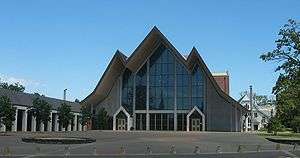
- The Anglican Cathedral, which stands at the top of the hill, is the most distinctive feature of Parnell. It replaced the old wooden St Mary's, demolished in 1888, having served the community for 28 years. The current building has two parts: the brick choir and body of the church date from about 1960 and represent a "modern" simplified version of Gothic. This closely resembles Guildford Cathedral, by Edward Maufe, completed in 1961. (Guildford exempllifies Municipal Gothic: one commentator described it as "the dying gasp of the Gothic Revival in England".) The massing of the forms, the detailing of the masonry and the smooth expanses of plain brick occur in both buildings. Over the transept entrance stands a bronze sculpture of the Archangel Michael defeating the Devil, very similar to the Epstein sculpture of the same subject on Coventry Cathedral (finished 1962). The front part of the church, built in the 1990s to the design of Professor Richard Toy and John Sinclair, recalls the new Coventry Cathedral built after World War II. It features large stained-glass windows, illuminated by the sunlight at certain times of the day. Māori motifs and symbols appear in the newer part of the building, which awaits a large spire to finish the composition.
- Old Saint Marys - Next to this building stands the smaller wooden Gothic St Mary's. This dates from 1885 and served as the pro-cathedral after the demolition of the earlier St Mary's and until the building of the current cathedral. Designed by B.W Mountfort, it stood on the other side of Parnell Road until the 1980s.
- Bishopscourt - St Stephens Avenue. Also known as Selwyn Court, this is the residence of the Anglican Bishop of Auckland. This wooden gothic house, designed by Frederick Thatcher, has a chapel and an octagonal turret. Bishop Selwyn and his wife moved here in May 1865.
- Neligan House - St Stephens Avenue. Fine Arts & Crafts brick Residence built for Bishop Neligan in 1908 by Noel Bamford & Hector Pierce.
- St Stephens House - St Stephens Avenue. Wooden Edwardian Mansion, now used for Anglican social services.
- The Old Deanery - St Stephens Avenue - A Frederick Thatcher designed Neo-Tudor house with volcanic Scoria rock probably by Benjamin Strange. This is probably the birthplace of the novelist Hugh Walpole whose father was Dean of the Cathedral at the time.
Northern area of Parnell
- Tower House - 33 St Stephen's Avenue. Landmark Brick mansion from 1904 with distinctive turret. The residence of A.E.T. Devore, Mayor of Auckland 1886-1889.
- Parnell Rose Gardens Dove Myer Robinson Park 85 to 87 Gladstone Road, Parnell. This park was created in 1913 as Parnell Park - (Parnell amalgamated with Auckland that year) largely as a result of the activities of Auckland Mayor Christopher Parr (later Sir James Parr). It was renamed in the 1970s to honour the popular and longest serving Mayor of Auckland, Sir Dove Myer Robinson. The park was created out of the gardens of several large estates which occupied the point in the late 19th century; primarily that of Sir John Logan Campbell and Justice Gillies; it enjoys expansive views of the beautiful Waitemata Harbour. This area consists of a number of different areas; the cottage style Nancy Stein Memorial Garden popular for wedding ceremonies; sweeping on down to Judges Bay and the salt water Parnell Baths. The Parnell Rose Garden is a major city attraction, containing beautifully maintained rose beds, and leads on to extended open spaces and areas with specimen trees. The park is also home to some remarkable native trees - the oldest manuka and largest Pohutukawa in Auckland. There are car parking facilities and nice artworks at the Fred Ambler Lookout, an open space that overlooks the container terminal.
- Judges Bay So-called because in 1841 Judge Martin and Attorney General Swainson arrived in Auckland with houses in prefabricated sections. Swainson built on the west side and the Martins on the east of this bay. Known as Taurarua ‘the two ropes’ it is thought that this name referred to the two administrators of British justice. From here Martin and his neighbour Swainson would commute to work in Auckland by rowboat; they employed maori boatmen who were supplied with uniforms. Lady Martin taught English to the local maori and late in her life wrote of her experiences in early colonial New Zealand.
- St Stephens Church and graveyard. Important early Anglican Chapel and cemetery.[7]
- Parnell Swimming Pool 1950 modernist design by the office of the City Architect Tibor Donner. It owes much to the AA trained architect, Ralph Wilkinson, who was then working in Donner’s office. Ewen Wainscott was site architect. noted for murals by James Turkington The complex won an NZIA Gold Medal in 1957. See Home & Building June 1950.
Southern area of Parnell
- Kinder House Scoria residence built for the Rev John Kinder (1819-1903)in 1857, of volcanic Scoria rock by Benjamin Strange. Now a museum, Kinder House is open to the public weekdays from 11am to 3pm. There is a modest entry charge. Various booklets and postcards are on sale. www.kinder.org.nz/
- Ewelme Cottage The kauri-constructed Ewelme Cottage has a link with the Anglican community in Auckland, the dwelling designed and built by the Reverend Vicesimus Lush (1817-1882) and his wife Blanche in 1863-64. Ewelme Cottage, was extended 18 years after it was originally built, it remained in family hands till 1968 when it became part of the New Zealand Historic Places Trust.
- Jubilee Building - The New Zealand Jubilee Institute for the Blind was founded in 1890 by John Abbott, Merchant, who came to New Zealand in 1864. The Institute school had originally been established in an old boarding house in Parnell in 1889. A more permanent school was built in 1891 with money from a mayoralty fund set up to celebrate the Jubilee of Queen Victoria, resulting in the name "Jubilee Institute". This building burnt down in 1897. Between 1907 and 1909, handsome new brick buildings were built for the Institute,designed by well-known architect Edward Bartley and built by W.Philcox and Sons. Additions in 1926 designed by Gummer and Ford provided for adult accommodation, a shop, workshops were the blind worked on various manufacturing projects, and a women's dormitory in 1927. The main building is now an Auckland City community centre and library, the subsidiary building are now used for a variety of purposes.
During the early 1970s the suburb became rather dilapidated. Les Harvey, a local businessman, bought up several properties cheaply and created "Parnell Village" encouraging others to follow his lead. This revitalised the area as a week-end tourist shopping-destination. This involved Parnell re-inventing itself as a set of "Ye Olde Worlde Shoppes". As many other Victorian buildings underwent demolition in Auckland at the time, period materials became available cheaply, and the buildings of Parnell village emerged altered, extended and tarted up in a somewhat fanciful but fun ersatz Victorian style. Much of this restyling remains in evidence within Parnell Village and around the Parnell Road shopping area, partly because of the ongoing ownership of the Harvey family's company, City Construction.
Along the upper part of Parnell Road stand a number of 19th century houses, most of them now used by law firms, accountancy firms, shops, and a few restaurants. The lower part of Parnell has a larger concentration of Edwardian retail buildings, including a number of fashionable boutiques, nightclubs and bars. The streets to each side of Parnell Road remain mainly residential in character, with some townhouses and apartments, especially towards St Georges Bay Road.
At the bottom of Parnell Rise runs Beach Road, so called because it ran round the beach-front of the now-reclaimed Mechanics Bay and Official Bay. St Georges Bay disappeared at the same time. Here stands the former Auckland Railway Station, an impressive brick 1930s structure, designed by Gummer and Ford. The City Fathers relocated the Railway Station here from the bottom of Queen Street to become the centrepiece for the new downtown business area of Auckland. The plan did not prove successful; the station building has ceased to operate as a station and the Britomart Transport Centre has taken over the earlier location. This has started to prove a great success.
Parks
Parnell has several parks.
- Dove-Myer Robinson Park, more commonly known as the Parnell Rose Garden - this park was created in 1913 as Parnell Park. Parnell Park was created by combining land belonging to several large houses, one of which (the home of the Gillies family) which was retained as the tearooms. One of the other properties belonged to Sir John Logan Campbell whose house Killbryde was demolished in 1924. The park is distinguished by many mature trees which were planted by the previous private owners. The park was renamed for Sir Dove-Myer Robinson, the longest serving mayor of Auckland, who served for 18 years. The Rose Gardens are popular for weddings and each year in November, the park is host to the Parnell Festival of Roses, which showcases New Zealand craft stalls, art exhibitions, music, strolling performers and thousands of roses. One portion of the garden is a collection of heritage roses collected by the late Nancy Steen. Nancy Steen Rose Garden The entrance to the park is a War Memorial built in the 1920s of volcanic basalt composed of three massive arches. The park enjoys views over the Waitemata Harbour; its grounds blend with those of the adjacent historic Anglican St Stephen's Chapel & graveyard, Judges Bay Reserve and Point Resolution Park with its Parnell Swimming Baths.
- Point Resolution Park This is located above the Parnell Swimming Baths and includes a walkway across the railway line and Tamaki Drive to contect with the Waitemata Harbour.
- Judges Bay Reserve Judges Bay and the adjacent Parnell Swimming Baths provide saltwater bathing.
- St Stephen's Churchyard One of Auckland's oldest cemeteries and the location of a Selwyn Church.
- Ayr Reserve Area of largely native bush accessible from Ayr Street.
- Alberon Reserve Area of native bush accessible from Alberon Street and St Georges Bay Road.
- Scarborough Reserve Area of Native bush accessible from Scarborough Terrace.
- Heard Park is located in the centre of Parnell Village. This land was donated to the city in 1953 by the Heard family, the owners of Heards Candy. The large Art-Deco Heards building is adjacent to the park, now no longer a working confectionery factory.[8]
- Fraser Park is located at the western end of Parnell Road. This triangular piece of land was previously the location of Parnell School, its wooden school buildings were demolished in the 1950s. It is also apparently known by locals as "Mike Robinson Park".
- Carlaw Park, which is located in Parnell, was the home of rugby league football in Auckland from 1921 to 2002.
- Auckland Domain, arguably also part of Grafton, it forms the western most edge of Parnell and houses extensive forrest, the Auckland Museum, and the Winter Gardens.[9]
Infrastructure
While Parnell has so far never had a dedicated train station, it is planned to construct a new station near the Mainline Steam Depot at the west of the Parnell shops area, north of the Parnell Tunnel, which has been located under the suburbs since 1873.[10]
Education
Parnell lies within easy reach of two universities (University of Auckland and Auckland University of Technology) and of some significant State secondary schools: Auckland Grammar School, Epsom Girls Grammar School, St Peter's College and Baradene College of the Sacred Heart.
Other private educational institutions located in Parnell include ACG Parnell College (a secondary school), Euroasia and Kaplan International Colleges.
Parnell District School, which caters for Year 1-8 students is the second oldest school in Auckland.
Notable residents
- William Martin,1807 - 1880 - The first Chief Justice of New Zealand - lived in Judges Bay - hence the name.
- William Swainson 1809–1884 - Attorney-General, member of the Executive and Legislative Councils, and writer - the other Judge who lived in Judges Bay
- Anglican Bishop of Auckland. Every bishop since George Selwyn has resided in the Palace; Bishops Court in St Stephen's Ave or Neligan House next door.
- Reverend John Kinder Anglican clergyman, watercolourist and early photographer. Kinder Cottage, Ayr Street
- Reverend Vicesimus Lush (1817-1882) and his wife Blanche in 1863-64. Ewelme Cottage Ayr Street.
- Sir Frederick Whitaker - Lawyer and New Zealand Premier - Built the house now known as Hulme Court.
- Lieutenant Colonel William Hulme (1788–1855)- Commander of British Troops in New Zealand - lived at Hulme Court, Parnell Road.
- Governor Colonel Sir Thomas Robert Gore Browne KCMG CB (3 July 1807 – 17 April 1887) - Governor of New Zealand 1855 - 1861. He used Hulme Court as a temporary Government House.
- Sir Francis Dillon Bell - Minister of Native Affairs and advisor to Governor Grey - resided at Hulme Court.
- Captain Thomas Sparrow Carmichael (1825-1900) - 66 St Georges Bay Road.
- Justice Gillies - house on Gladstone Road - now the Tearooms for the Parnell Rose Gardens.
- Sir John Logan Campbell and Lady Campbell - lived on Gladstone road, the house Killbryde was demolished in 1924 and the land incorporated in the Parnell Rose Gardens.
- Hugh Walpole - Novelist - Walpole was born in Parnell, probably in the Anglican Deanery in St Stephen's Avenue.
- John Key, Prime Minister (2008- ) lives in a NZ$9 million private mansion on St Stephen's Avenue.[11]
- A.E.T. Devore, Mayor of Auckland 1886-1889.
- Patrick Steel - Fashion designer - Young Designer of the Year at the 1974 Benson & Hedges Fashion Design Awards.
- Sir Harcourt Caughey KBE CSTJ (1911–1993). An All Black from 1932 to 1937, Thomas Harcourt Clarke Caughey was managing director of the family firm, the Smith & Caughey Department Store. He was knighted in 1972.
- Sanesh Francis[12] - Socialite - home on Cheshire Street by the Auckland Domain
Further reading
- The Heart of Colonial Auckland, 1865-1910. Terence Hodgson. Random Century NZ Ltd 1992. ISBN 1-86941-148-X
- Colonial Architecture In New Zealand. John Stacpoole. A.H & A.W Reed 1976.
- Decently And In Order, The Centennial History of the Auckland City Council. G.W.A Bush. Collins 1971.
- Auckland Through A Victorian Lens. William Main. Millwood Press, 1977.
- Auckland's Original Shoreline. Dr Neride Campbell. Heart of the City 2005.
- The Lively Capital, Auckland 1840–1865. Una Platts. Avon Fine Prints Limited New Zealand 1971.
References
- ↑ HomeTopia. "HomeTopia > Find Me A Home > Suburb Sleuth - Selection > Suburbs". www.hometopia.co.nz. Retrieved 2016-09-22.
- ↑ Truttman, Lisa (29 May 2013). "Tod's box in Parnell". Timespanner. Retrieved 4 May 2016.
- ↑ "History of Auckland City. Selected Auckland City chronology 1840-1998". Archived from the original on 20 February 2008. Retrieved 23 February 2008.
- ↑ "History of Auckland City. Chapter 2: Building a solid city (1871-1918)". Archived from the original on 16 February 2008. Retrieved 23 February 2008.
- ↑ Parnell, The Cyclopedia of New Zealand [Auckland Provincial District], pp. 509–515. The Cyclopedia Company, Ltd, 1902, Christchurch. Retrieved 11 October 2010.
- ↑
- ↑ "St Stephen's Chapel". Register of Historic Places. Heritage New Zealand. Retrieved 12 March 2016.
- ↑ "Parks & Recreation - Parnell Inc". Parnell.net.nz. Retrieved 2016-03-12.
- ↑ "NZ Gardens Trust - Auckland". www.gardens.org.nz. Retrieved 2016-09-22.
- ↑ "ARC presses for Parnell train station". The New Zealand Herald. 30 September 2010. Retrieved 12 January 2011.
- ↑ Lewis, Rebecca (16 November 2008). "And now John Key won't live here either". The New Zealand Herald. Retrieved 1 November 2011.
- ↑ "Sanesh Anton Francis (@saneshfrancis) • Instagram photos and videos". www.instagram.com. Retrieved 2016-09-22.
External links
| Wikimedia Commons has media related to Parnell, New Zealand. |
- Parnell Business Associations Guide to Parnell
- Parnell Heritage Walks
- What's happening in Parnell
- Parnell History
- Parnell District School
- Photographs of Parnell held in Auckland Libraries' heritage collections.
Coordinates: 36°52′S 174°47′E / 36.867°S 174.783°E