Rangitoto Island
| Maori: Rangitoto | |
|---|---|
|
Rangitoto Island from One Tree Hill | |
 Rangitoto Island | |
| Geography | |
| Location | Auckland |
| Coordinates | 36°47′12″S 174°51′36″E / 36.786742°S 174.860115°E |
| Highest point | 260 m (850 ft) |
| Administration | |
|
New Zealand | |
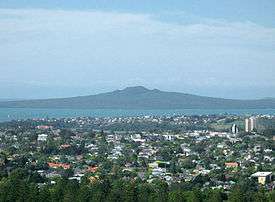
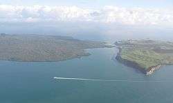
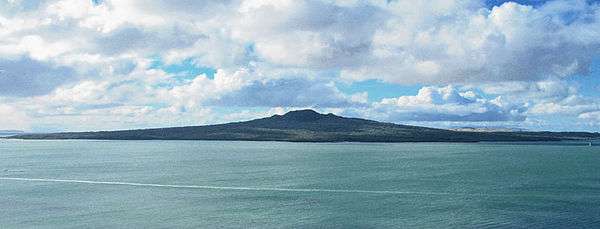
Rangitoto Island is a volcanic island in the Hauraki Gulf near Auckland, New Zealand. The 5.5 km wide island is an iconic and widely visible landmark of Auckland with its distinctive symmetrical shield volcano cone rising 260 metres (850 ft) high over the Hauraki Gulf.[1][2] Rangitoto is the most recent and the largest (2311 hectares)[3] of the approximately 50 volcanoes of the Auckland volcanic field.[2] It is separated from the mainland of Auckland's North Shore by the Rangitoto Channel. Since World War II it has been linked by a causeway to the much older, non-volcanic Motutapu Island.[4]
Rangitoto is Māori for 'Bloody Sky',[5] with the name coming from the full phrase Ngā Rangi-i-totongia-a Tama-te-kapua ('The days of the bleeding of Tama-te-kapua'). Tama-te-kapua was the captain of the Arawa waka (canoe) and was badly wounded on the island, at a (lost) battle with the Tainui iwi (tribe) at Islington Bay.[3][6]
Geology
Rangitoto was formed by a series of eruptions commencing at least 6000 years ago.[7] The most recent eruptions occurred between 550 and 600 years ago in two episodes, 10 to 50 years apart, and are thought to have lasted for several years during the later shield-forming episode. The first recent episode erupted most of the volcanic ash that mantles neighbouring Motutapu Island, and produced the lower, northern scoria cone. The second episode built most of Rangitoto, erupting all the lava flows and main scoria cone at the apex.[8] The 2.3 cubic kilometres of material that erupted from the volcano was about equal to the combined mass produced by all the previous eruptions in the Auckland volcanic field, which were spread over more than 250,000 years.[6][9]
In 2013, scientists said new studies showed Rangitoto had been much more active in the past than previously thought, suggesting it had been active on and off for around 1000 years before the final eruptions around 550 years ago.[10] In February 2014 a 150m deep hole was drilled through the western flank of Rangitoto. This revealed a history of activity going back at least 6000 years, with the bulk of activity post-dating 3800 years. Civil Defence officials said the discovery did not make living in Auckland any more dangerous, but did change their view of how an evacuation might proceed.[11] The fact that Rangitoto Island has erupted off and on for a long period of time demonstrates that it is the only known polygenetic volcano in the Auckland volcanic field.[12] It is possible that Rangitoto includes a cluster of several small volcanoes that are now covered by the main shield.[13][14]
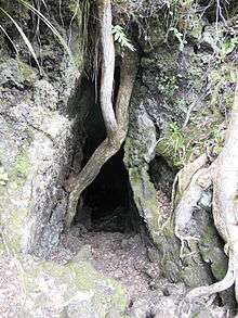
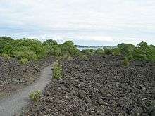
Subsidence back down the throat during the cooling process has left a moat-like ring around the crater summit, which may be viewed from a path which goes right round the rim and up to the highest point.[3][6] In some parts of the island, fields of lightweight, clinker-like black lava stones called scoria are still exposed, appearing very recent to a casual eye. About 200 metres from the top of the mountain on the eastern side visitors can walk through some of about seven known lava tubes — tubes left behind after the passage of liquid lava. The more accessible of the caves are signposted.[6] Lava tubes are formed when low-viscosity molten lava known as pahoehoe flows and cools on the outside due to contact with the ground and air, to form a hard crust allowing the still-liquid molten lava to continue to flow through inside. At Rangitoto the large tubes are cave-like. A torch is needed to explore the caves. The longest known cave is about 50 m long.[15]
History
Māori association
The volcano erupted within the historical memory of the local Māori iwi (tribes).[6][9] Human footprints have been found between layers of Rangitoto volcanic ash on the adjoining Motutapu Island.[9] Ngāi Tai was the iwi living on Motutapu, and considers both islands their ancestral home. Ngāti Paoa also has links with Rangitoto.[16]
A number of Māori myths exist surrounding the island, including that of a 'tupua' couple, children of the Fire Gods. After quarreling and cursing Mahuika, the fire-goddess, they lost their home on the mainland because it was destroyed by Mataoho, god of earthquakes and eruptions, on Mahuika's behalf. Lake Pupuke on the North Shore was created in the destruction, while Rangitoto rose from the sea. The mists surrounding Rangitoto at certain times are considered the tears of the tupua for their former home.[6]
Since European colonisation
The island was purchased for ₤15 by the Crown in 1854, a very early date in New Zealand's colonisation by Europeans, and for many years served as a source of basalt for the local construction industry.[17] It was set aside as a recreation reserve in 1890, and became a favourite spot for daytrippers.[17] Some development occurred nonetheless. In 1892, salt works were created on 5 acres (20,000 m2) near Mackenzies Bay. The wharf and summit road were opened in 1897, with another road linking the summit to Islington Bay by 1900.[18] For over 30 years (from 1898 to 1930), scoria was quarried from near the shoreline on the west side of Islington Bay[19] as building material for Auckland.[20] From 1925 to 1936, prison labour built roads on the island and a track to the summit.[3] Islington Bay was formed in the South East area of the island. Formerly known as Drunks Bay, it was used as a drying out area for inebriated crews before they ventured out of the gulf. The bay is very popular with Auckland boaties as a refuge, as it is quite sheltered from the prevailing South West winds. In summer it is not unusual to find 30 boats anchored overnight.
Military installations were built during World War II to support the Auckland harbour defences and to house U.S. troops or store mines. The most visited remains of these installations is the old observation post on the summit. The northern shore of the island was used as a wrecking ground for unwanted ships, and the remains of several wrecks are still visible at low tide.[21][22]
Baches (small holiday houses) were built around the island's edge in the 1920s and 1930s. The legality of their existence was doubtful from the start and the building of further baches was banned in 1937. Most have since been removed because of the ban and because the island has become a scenic reserve. However some 30 of the 140 baches remain as of 2010,[17] and some are being preserved to show how the island used to be, once boasting a permanent community of several hundred people, including a good number of children. The buildings included some more permanent structures like a seawater pool built of quarried stones by convict labour, located close to the current ferry quay.[23]
There are several daily ferries to the island from Auckland's main ferry terminal, currently run by Fullers. These allow day trips for the fit to walk to the summit and back, with stunning views of the harbour and city. An alternative to walking, a land train, co-ordinated with the ferry sailings, takes visitors to a short way below the summit.[24] Sea kayak trips from the mainland to the island are also available[25] Accommodation on the island is limited to a small number of dwellings near the wharf, one of which is available for public hire. There are no campsites on the island, though there is camping at Home Bay on the adjacent Motutapu Island.
Biology
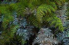
There are virtually no streams on the island so plants rely on rainfall for moisture. It has the largest forest of pōhutukawa trees in the world,[3] as well as many northern rātā trees. In total, more than 200 species of trees and flowers thrive on the island, including several species of orchid, as well as more than 40 types of fern.[6]
The island is considered especially significant because all stages from raw lava fields to scrub establishment and sparse forests are visible. As lava fields contain no soil of the typical kind, windblown matter and slow breaking-down processes of the native flora are still in the process of transforming the island into a more habitable area for most plants (an example of primary succession), which is one of the reasons why the local forests are relatively young and do not yet support a large bird population. However, the kākā, a New Zealand-endemic parrot, is thought to have lived on the island in pre-European times.[6]
Goats were present on Rangitoto in large numbers in the mid 19th century, but were eradicated in the 1880s. Fallow deer were introduced to Motutapu in 1862 and spread to Rangitoto, but disappeared by the 1980s. The brush-tailed rock-wallaby was introduced to Motutapu in 1873, and was common on Rangitoto by 1912, and the brushtail possum was introduced in 1931 and again in 1946. Both were eradicated in a campaign from 1990 to 1996 using 1080 and cyanide poison and dogs.
Stoats, rabbits, mice, rats, cats and hedgehogs remained a problem on the island,[26] but the Department of Conservation (DOC) aimed to eradicate them beginning with the poisoning of black rats, brown rats and mice and in August 2011, both Rangitoto and neighbouring Motutapu Islands were officially declared pest-free with both islands now also boasting populations of newly translocated North Island saddlebacks.[27]
As the area is a DOC-administered reserve (in partnership with the 'tangata whenua' Ngāi Tai and Ngāti Paoa),[5] visitors may not take dogs or other animals onto the islands.[24]
Access
Regular ferry services are provided by Fullers and Explore from downtown Auckland. The distance to the summit is 2.4 km (1.5 mi) / 1 hour(by Walk), by the most direct route.
See also
- Volcanism in New Zealand
- Under the Mountain was a novel, TV series and film set around Rangitoto.
References
- ↑ "Auckland Field – Photo Gallery". Global Volcanism Program. Smithsonian Institution. Retrieved 2008-06-21.
- 1 2 "Auckland Field". Global Volcanism Program. Smithsonian Institution. Retrieved 2009-04-29.
- 1 2 3 4 5 Hauraki Gulf Islands – Rangitoto Island, Auckland City Council. Updated September 2008. Retrieved 29 April 2009.
- ↑ Ottaway, Jacqueline Crompton (30 April 2004). "Rangitoto – Auckland's Fragile Icon". NZine. Retrieved 26 April 2010.
- 1 2 What happened to local Maori? (from the Rangitoto page on the GNS Science website)
- 1 2 3 4 5 6 7 8 Rangitoto (from the Auckland Regional Council website)
- ↑ Shane, Phil; Linnell, Tamzin (March 2015). "Reconstructing Rangitoto volcano from a 150-m-deep drill core (project 14/U684)" (PDF). University of Auckland. Retrieved 6 October 2015.
- ↑ Hayward, B.W.; Murdoch, G., Maitland, G. (2011). Volcanoes of Auckland: The Essential Guide. Auckland University Press.
- 1 2 3 Rangitoto (abridged article from New Zealand National Geographic)
- ↑ "Rangitoto more active than thought - study". 3 News NZ. 11 April 2013. Retrieved 9 April 2016.
- ↑ "Officials downplay volcano danger". 3 News NZ. 12 April 2013. Retrieved 9 April 2016.
- ↑ McGee, L.; Beier, C.; Smith, I. E.; Turner, S. (2009). "Polygenetic magmatism in a monogenetic field: an isotopic investigation from the Auckland Volcanic Field, New Zealand". American Geophysical Union. Retrieved 2015-12-23.
- ↑ Morton, Jamie (28 March 2016). "Volcano hiding explosive secret". The New Zealand Herald. Retrieved 9 April 2016.
- ↑ Linnell, Tamzin; et al. (2016). "Long-lived shield volcanism within a monogenetic basaltic field: The conundrum of Rangitoto volcano, New Zealand". Geological Society of America Bulletin. doi:10.1130/B31392.1.
- ↑ Auckland University, Geology Dept, field guide
- ↑ Mike D Wilcox; et al. (2007). Natural History of Rangitoto Island. Auckland Botanical Society. p. 16. ISBN 978-0-9583447-3-9.
- 1 2 3 "The Hauraki Gulf Marine Park, Part 2". Inset to The New Zealand Herald. 2 March 2010.
- ↑ Gordon Ell (1980). Rangitoto. Bush Jacket Guides. Auckland: The Bush Press. ISBN 0-908608-04-7.
- ↑ Wolfe, R. (2002). Auckland: a pictorial history. Auckland: Random House. p 228.
- ↑ Glenys Robertson (2005). Exploring North Island Volcanoes. Auckland: New Holland Publishers. p. 126. ISBN 1-86966-078-1.
- ↑ "Rangitoto Ships' Graveyard". Auckland Regional Council website. Retrieved 2008-06-08.
- ↑ . Flinders University website = Rich Pickings: Abandoned Vessel Material Reuse on Rangitoto Island, New Zealand http://www.academia.edu/11749065/Rich_Pickings_Abandoned_Vessel_Material_Reuse_on_Rangitoto_Island_New_Zealand = Rich Pickings: Abandoned Vessel Material Reuse on Rangitoto Island, New Zealand Check
|url=value (help). Retrieved 2016-02-06. Missing or empty|title=(help) - ↑ Welcome to Rangitoto Island (from the Rangitoto Island Historic Conservation Trust)
- 1 2 Rangitoto Island – Unique Volcanic Island (from the Fullers ferry operator website)
- ↑ Kayak Trips to Rangitoto (Day Trips to Rangitoto Island)
- ↑ Mike D Wilcox; et al. (2007). Natural History of Rangitoto Island. Auckland Botanical Society. pp. 23–24. ISBN 978-0-9583447-3-9.
- ↑ Rangitoto & Motutapu restoration project, Department of Conservation.
Further reading
- Jamieson, Alastair (2004). "Rangitoto". New Zealand Geographic. 68.
- Julian, Andrea (1992). The vegetation pattern of Rangitoto. University of Auckland PhD thesis
- Whiting, Diana (1986). Vegetation colonisation of Rangitoto Island: the role of crevice microclimate. University of Auckland Masters thesis
- Bennett, Kurt (2014). Rich pickings: Abandoned vessel material reuse on Rangitoto Island, New Zealand (PDF). Flinders University.
External links
| Wikimedia Commons has media related to Rangitoto Island. |
- Rangitoto Island Scenic Reserve at the Department of Conservation
- Rangitoto Island Historic Conservation Trust
- Photographs of Rangitoto Island held in Auckland Libraries' heritage collections.
Coordinates: 36°47′12″S 174°51′36″E / 36.786742°S 174.860115°E