Ranzanico
| Ranzanico | |
|---|---|
| Comune | |
| Comune di Ranzanico | |
|
Ranzanico | |
 Ranzanico Location of Ranzanico in Italy | |
| Coordinates: 45°47′N 9°56′E / 45.783°N 9.933°ECoordinates: 45°47′N 9°56′E / 45.783°N 9.933°E | |
| Country | Italy |
| Region | Lombardy |
| Province / Metropolitan city | Province of Bergamo (BG) |
| Area | |
| • Total | 7.0 km2 (2.7 sq mi) |
| Elevation | 519 m (1,703 ft) |
| Population (Dec. 2004) | |
| • Total | 1,167 |
| • Density | 170/km2 (430/sq mi) |
| Demonym(s) | Ranzanicesi |
| Time zone | CET (UTC+1) |
| • Summer (DST) | CEST (UTC+2) |
| Postal code | 24060 |
| Dialing code | 035 |

Ranzanico is a comune (municipality) in the Province of Bergamo in the Italian region of Lombardy, located about 70 kilometres (43 mi) northeast of Milan and about 25 kilometres (16 mi) northeast of Bergamo. As of 31 December 2004, it had a population of 1,167 and an area of 7.0 square kilometres (2.7 sq mi).[1]
Ranzanico borders the following municipalities: Bianzano, Endine Gaiano, Gandino, Monasterolo del Castello, Peia, Spinone al Lago.
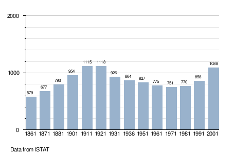
Demographic evolution
References
| Wikimedia Commons has media related to Ranzanico. |
This article is issued from Wikipedia - version of the 8/16/2016. The text is available under the Creative Commons Attribution/Share Alike but additional terms may apply for the media files.