Gandellino
| Gandellino | |
|---|---|
| Comune | |
| Comune di Gandellino | |
|
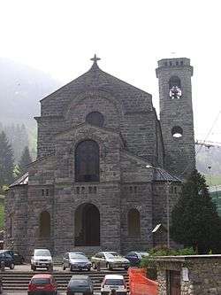
Church | |
 Gandellino Location of Gandellino in Italy | |
| Coordinates: 46°0′N 9°57′E / 46.000°N 9.950°ECoordinates: 46°0′N 9°57′E / 46.000°N 9.950°E | |
| Country | Italy |
| Region | Lombardy |
| Province / Metropolitan city | Province of Bergamo (BG) |
| Frazioni | Gromo San Marino , Foppi , Tezzi , Pietra , Bondo , Grabiasca , San Giorgio |
| Area | |
| • Total | 25.4 km2 (9.8 sq mi) |
| Elevation | 675 m (2,215 ft) |
| Population (Dec. 2004) | |
| • Total | 1,096 |
| • Density | 43/km2 (110/sq mi) |
| Demonym(s) | Gandellinesi |
| Time zone | CET (UTC+1) |
| • Summer (DST) | CEST (UTC+2) |
| Postal code | 24020 |
| Dialing code | 0346 |
Gandellino is a comune (municipality) in the Province of Bergamo in the Italian region of Lombardy, located about 90 kilometres (56 mi) northeast of Milan and about 40 kilometres (25 mi) northeast of Bergamo. As of 31 December 2004, it had a population of 1,096 and an area of 25.4 square kilometres (9.8 sq mi).[1]
The municipality of Gandellino contains the frazioni (subdivisions, mainly villages and hamlets) Gromo San Marino, Foppi, Tezzi, Pietra, Bondo, Grabiasca, and San Giorgio.
Gandellino borders the following municipalities: Carona, Gromo, Valbondione, Valgoglio.
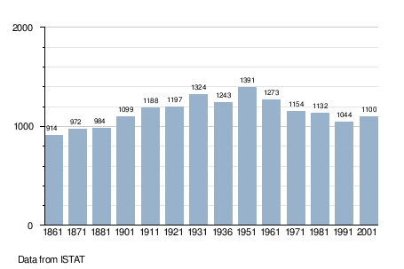
Demographic evolution
References
This article is issued from Wikipedia - version of the 8/16/2016. The text is available under the Creative Commons Attribution/Share Alike but additional terms may apply for the media files.