Quinchía
| Quinchía | ||
|---|---|---|
| Town and Municipality | ||
| Quinchía | ||
| ||
| Nickname(s): Villa de los Cerros, (Village of the Hills) | ||
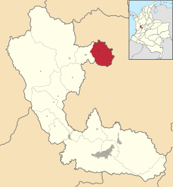 Location of Quinchía in the department of Risaralda. | ||
 Quinchía Location of Quinchía in the department of Risaralda. | ||
| Coordinates (Urban area): 5°20′16.26″N 75°43′46.73″W / 5.3378500°N 75.7296472°WCoordinates: 5°20′16.26″N 75°43′46.73″W / 5.3378500°N 75.7296472°W | ||
| Country |
| |
| Department |
| |
| Region | Andean Region of Colombia | |
| Cultural Area | Colombian Coffee-Growers Axis | |
| Founded | 1888 | |
| Administrative Division |
Boroughs
| |
| Government | ||
| • Type | Strong Mayor-Council | |
| • Mayor | Alicia Palacio Restrepo (2008-2011) | |
| Area | ||
| • Total | 149.8 km2 (57.8 sq mi) | |
| Elevation | 1,825 m (5,988 ft) | |
| Population (2005)Census | ||
| • Total | 31,996 | |
| • Density | 210/km2 (550/sq mi) | |
| According to National Department for Statistics of Colombia (DANE) | ||
| Time zone | Bogotá, (Colombia). (UTC-5) | |
| Website | http://quinchia-risaralda.gov.co/index.shtml | |
.svg.png)
Quinchía, also known as Villa de los Cerros (Village of the Hills), is a town and municipality in the Department of Risaralda, Colombia. In 1985 Quinchía was described as the prettiest village of Risaralda, for governor of that department. Sebastian Belalcázar was the first European to arrive in this territory.
External links
- Official Website Official website of Quinchía's Town Hall.
- Hospital Nazareth Hospital Nazareth, located at the urban area of Quinchía, provides health services to local community.
- QTV Blog of the local radio station an TV channel. Radio Quinchía Televisión.
- Quinchía.com Website about Quinchía, Risaralda.
Municipalities in the Risaralda Department | ||
|---|---|---|
This article is issued from Wikipedia - version of the 11/14/2016. The text is available under the Creative Commons Attribution/Share Alike but additional terms may apply for the media files.