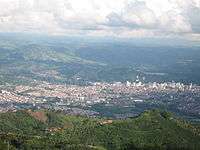
Pereira, Colombia
| Pereira | |||
|---|---|---|---|
| City | |||
 | |||
| |||
| Nickname(s): La Querendona, Trasnochadora y Morena | |||
| Motto: Pereira con Vida | |||
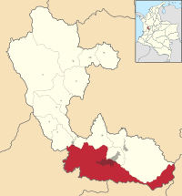 Location of the city and municipality of Pereira in Risaralda Department. | |||
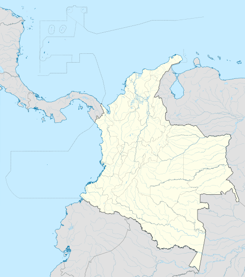 Pereira Location in Colombia | |||
| Coordinates: 4°48′51.4″N 75°41′40.41″W / 4.814278°N 75.6945583°WCoordinates: 4°48′51.4″N 75°41′40.41″W / 4.814278°N 75.6945583°W | |||
| Country | Colombia | ||
| Department | Risaralda | ||
| Region | Andean | ||
| Foundation | August 30, 1863 | ||
| Government | |||
| • Mayor | Juan Pablo Gallo Maya | ||
| Area | |||
| • City | 702 km2 (271 sq mi) | ||
| • Metro | 628 km2 (242 sq mi) | ||
| Elevation | 1,411 m (4,629 ft) | ||
| Population (2016 est.) | |||
| • City | 472,023 | ||
| • Density | 670/km2 (1,700/sq mi) | ||
| Demonym(s) | Pereiran | ||
| Time zone | Eastern Time Zone (UTC-05) | ||
| Area code(s) | 57 + 6 | ||
| Website | Official website (Spanish) | ||
Pereira is the capital city of the Colombian department of Risaralda. It is located in the foothills of the Andes in a coffee-producing area of Colombia officially known as the "Coffee Axis". Pereira, alongside the rest of the Coffee Axis, form part of UNESCO World Heritage Site known as the "Coffee Cultural Landscape of Colombia".[1] It is the most populated city in the Coffee Axis and the second-most populated city in the Paisa region, after Medellín. Pereira is also part of the Central West Metropolitan Area, which has over 1,000,000 residents and is composed of Pereira and the neighboring cities of Dosquebradas and La Virginia.
As the capital of the department of Risaralda, Pereira houses the headquarters of the Government of Risaralda, the Departmental Assembly, the Departmental Court, the Metropolitan Area Authority and the Attorney General. It also serves as the headquarters for numerous public companies and institutions of the Colombian state. Being in the center of the Golden Triangle (which consists of the cities of Bogotá, Medellín, and Cali), Pereira has become especially important in the fields of trade and commerce.
Toponymy
Pereira owes its name to the lawyer Francisco Pereira Martínez, a man who was close to the fight for independence for a city in the territory that once belong to the old Cartago. The village of Pereira was named in honor of him after his death.
The city of Pereira is known as "la querendona, trasnochadora y morena" and "the pearl of Otún".
Location
Pereira is located in what is known as the Golden Triangle, because it is located in the middle of Bogota, Medellin and Cali. Pereira is located in the Central Cordillera (mountain range) of Colombia in the valley of the river Otún and part of the Cauca river valley. To the north is La Virginia, Marsella and Dosquebradas. To the northeast is Santa Rosa de Cabal and to the east is Tolima. To the south is Quindío and Valle del Cauca and to the west is Balboa and Valle del Cauca.
Geography

The municipal area is 702 km²; Limits to the north with the municipalities of La Virginia, Marseilles and Dosquebradas, to the northeast with Santa Rosa de Cabal and to the east with the department of Tolima, to the south with the departments of Quindío and Valle del Cauca, to the west with the municipality of Balboa and The department of Valle del Cauca.
Pereira is located on the central mountain range, on the Otún river valley, and part of the Cauca river valley. Pereira, like many Colombian cities, has high areas with difficult access or flat or steep parts. The streets are made according to the relief of the zone, case such as the Avenue the River that crosses the valley of the river Otún, reason why it has few elevations but has several lateral undulations.
The greater part of the municipal territory corresponds to the sheer relief of the Central Mountain range. Among the orographic accidents are the snowcapped Quindio, Ruiz and Santa Isabel, located in the limits with the departments of Quindío, Caldas and Tolima respectively. It also has other accidents like Santa Barbara, also known as the Alto del Nudo. The hydrographic system of the municipality includes the rivers Cauca, Barbas, La Vieja, Otún and Consota, with its many tributaries. Because of the broken of its relief, enjoys of variety of climates, presenting / displaying the following thermal floors: warm, 60 km ²; Medium, 367 km²; Cold, 70 km ² and páramo, with 107 km ².
Climate
The climate of Pereira oscillates between the following topics: Warm climate 9.9%, average climate 60.7%, cold climate 11.5%, paramo 17.7%, its annual average rainfall is 2,750 mm.
The Pereirano territory, which extends mainly from east to west, gives the city different climates within this, such is the case, the corregimientos of caimalito and cerritos to the west of the city, near the river Cauca, its temperature is approaching To the 28 degrees, since the height in this zone is from 950 to 1250 msnm) At the other end is the sector of the Julita, where also is the Technological University of Pereira, that due to the territory occupied by main forests And secondary, is one of the coldest areas of the city, in addition to its high humidity. The temperature in this zone oscillates about the 18 degrees, and its average height is of 1550 msnm.
This climatic characteristic and the conformation of the soils, also offers a variety in the vegetation and landscape coverage, enhancing the municipality of Pereira with one of the richest biodiversities of the nation. However, the city presents itself as an area of high seismic vulnerability due to the type of soils that make up it and the geological faults that cross it. Its average temperature is 22 degrees Celsius.
Waterways
The main lake in the city is the Lake Otun, which feeds the River Otun. The river system of the municipality includes the rivers Cauca, The Barbas River, The Old River, The Otún River, the Consota and many tributaries.
History
The history of the city goes back to pre-Columbian times, in which the area that today comprises the city was inhabited by the tribes of the Quimbaya and Pijao cultures, widely recognized for their goldsmiths. In this region, Marshal Jorge Robledo founded the city of Carthage on August 9, 1540, but the siege of the pijaos or reasons of economic expediency, produced the transfer of this city to the site that currently occupies in the north of the Valley of the Cauca, in 1691, towards the banks of the La Vieja river. Then the region became jungle again and buried the remains of civilization. On the few ruins of the Spanish population, crossed by the route that led from Valle del Cauca to Medellín, through Manizales, a group of 20 Antioqueno families had already built their homes when a handful of Vallecaucanos appeared to found the population of Carthage La Vieja, today Pereira. Although the formal initiative of the foundation came from the Caucano group, the emergence of Pereira was another chapter of the Antioqueno colonization, and the contribution of other social groups such as the Caucano was in its beginning relatively scarce.
Later, with the ideal of reviving this city, which until then was a jungle area, on August 24, 1863, the presbyter Remigio Antonio Cañarte and Jesús María Ormaza Niño, among others, returned to the ruins of ancient Carthage, where Established a few huts that were blessed on August 30 of the same year (1863)
For 6 years old Carthage was called, but in 1869 the municipality of Carthage gave the name of Villa de Pereira, in honor to the doctor Francisco Pereira Martínez, that in 1816 took refuge in the zone, along with its brother Manuel Pereira, after the Defeat of the patriotic hosts of Simón Bolívar in the battle of Cachirí and soon manifest the desire that a city was established in those lands.
From 1870 and especially as a result of the civil wars of 1876 and 1885, the region received a new wave of immigrants from Antioquia. With the circumstance that it was now a human element of different social and psychological conditions. The group of 1863 and following years had been formed by forest reclaimers who only aspired to have a single plot; The second group was made up of men of greater ambition and greater entrepreneurial capacity. Some of them were linked to Antioquian capitals that financed their activities, which demolished mountains and opened cattle ranches using peonadas and heavy capital investments.
The arrival in the city of a group of merchants and professionals at the end of the last century and beginning of the present, introduced education as a new reason for social differentiation. A group emerged that became a leader of the economic, civic and political activities of the city, thanks to a greater degree of cultural.
In the 1950s, during the period of "violence", a period of bipartisan political struggle in the country, Pereira became a refuge for thousands of Colombians, quadrupling its population and creating a national melting pot that changed its community forever , Condensing the vocation of plural city that would have in future.
In recent years, the city has achieved an urban identity and a significant growth in its cultural level; Social integration and the highest level of education are allowing the city a sustained growth, not only economic but also cultural.
Pereira was the city where the last execution took place in Colombia: on several occasions the Court saved minors of good behavior from the last torture and at other times condemned them; Such as David López, 19, who was indicted for the murder of Ricardo Torres on November 30, 1888. Lopez unsuccessfully exhausted the resources to save his life; Died in Pereira on July 26, 1890, after telling the peloton to shoot directly at the heart. David López was shot in Pereira and became the last law-enforced execution in Colombia.
In the 1920s particularly, settlers from Antioquia moved to Pereira for its economically strategic location, fertile soil, and good weather. The settlers grew large quantities of high-quality coffee in the mineral-rich, volcanic, Andean soil.[2] Other produce included sugarcane and cattle.[3] Settlers also came from cities such as Valle del Cauca and Bogotá. In the economic recession of 1999, and the low-growth years of 2000 and 2001, some residents of Pereira emigrated to the United States and Spain.
Towards the years 2005 and 2006, Pereira recovered from decline and went into an economic boom, with new office, retail and housing development, and most importantly Megabus, the main public transportation system in the area was opened to the public.
In the year 2015 the new Biopark Ukumari, was opened to the public, in its initial phase with 2 bioregions. It is planned to have up to 8 bioregions including Andean Mountains, African Desert, Amazonas and many more, including a section designed for mechanical rides.
During these year up until 2016, Pereira has been an epicenter of massive urban redevelopment with many worldwide companies opening in Pereira new stores, factores and logistical centers. The unemployment rate has lowered significantly from being one of the highest in the country, to the national standard of 9%. Pereira is starting to convert into the capital city of the Coffee Axis or Eje Cafetero region, with many residents from many neighbouring cities like Armenia and Manizales coming to Pereira to buy good and clothes in stores that are unique to Pereira.
Governance

The Pereira municipal area covers 702 square kilometres (702,000,000 m2). Pereira is divided into 19 neighbourhoods: Ferrocarril, Olímpica, San Joaquín, Cuba, Del Café, El Oso, Perla del Otún, Consota, El Rocío, El Poblado, El Jardín, San Nicolás, Centro, Río Otún, Boston, Universidad, Villavicencio, Oriente y Villasantana.
Pereira has also rural neighbourhoods called Altagracia, Arabia, Caimalito, Cerritos, La Florida, Puerto Caldas, Combia Alta, Combia Baja, La Bella, Estrella- La Palmilla, Morelia, Tribunas. Pereira together with La Virginia, and Dosquebradas form the Area Metropolitana de Centro Occidente (AMCO). This means the three cities work together and share many services like Megabus for a better living for all the citizens.
Demographics
In 2005, Pereira had about 576,329 residents and was the sixth largest city of Colombia. Pereira has a twin city, Dosquebradas (about five minutes drive from the Plaza de Bolivar), which has about 200,000 residents. With a total population of about 986,000, the Pereira conurbation also includes La Virginia. Pereira, Dosquebradas and La Virginia comprise the Pereira metropolitan area. As a result of urbanisation, Pereira has one of the most equitable distributions of wealth in Colombia.[4]
Economy

The municipality of Pereira has a diversified economy in its economic structure, the primary sector accounts for 5.7% of the GDP, the secondary sector shows a relative weight of 26.2% in the municipality and the tertiary sector is the most representative with magnitudes 68.1%. Pereira's grew 3.7% in 2004, certainly this year was successful where several events revived the economy, as the flagship program of the national government, greater fluidity in the financial system, residents sent overseas who have an important impact on consumption, the above accompanied by improved oil prices, coal, nickel, coffee. These developments were reflected in the increase in both the supply and demand for goods and services.
Trade is the second generating employment activity, Pereira has been carrying out a process in formal trade, an important part is already in shopping centers (Alcides Arevalo, Bolivar Plaza, Lake Plaza, Novacentro, Parque Arboleda, Pereira Plaza, Victoria, Unicentro, etc.) where there is a wide variety of products and services which can be seen in the short term as successful.
Hotels and resorts in recent times have been constructed, several establishments located in downtown Pereira and in the outskirts such as Sonesta Cerritos which can be interpreted as an expansion of visitors to the city for various reasons, creating added value in different sectors.
Agriculture
In the region of Pereira, agricultural employment is 70 percent in permanent cropping, 8 percent in annual crops and 22 percent engaging transient workers. Agricultural products include a variety of crops such as sugarcane, cacao and rubber, cereals, coffee and livestock. Pereira is part of the Colombian coffee growing axis.[3]
Manufacturing
Pereira's main manufacturing product is apparel. Other products include aluminium goods, motorcycles and telecommunications technology. Pereira also hosts multinational corporations such as Avesco, Nestle and Coats. In the future, Ethanol may be produced in Pereira, as sugarcane (an essential raw material for ethanol production) is farmed in the nearby Cauca valley.[5]
Logistics
Pereira is a centre for transport logistics. Logistics companies include Servientrega International Logistics, FedEx, DHL, Central and TCC. There are logistics centres in Dosquebradas and Alpina.
In 2016, two major companies opened logistal centers in Pereira. The first was Deprisa, the subsidiary company of Avianca of correspondence and mail, it opened in Pereira as a logistal center of the whole Region of the Coffee Axis. The second being the Logistical center for the national supermarket chain Exito, with a logistical center serving as well as before, the entire Coffee Axis Region, that compromises the cities of Manizales, Pereira, Armenia and Cartago.
Pereira is also in the process of being two logistical parks, which already houses important national companies like D1 Supermarkets distribution center, as well as Alberto VO5 national distribution center.
Pereira also houses the Zona Franca, or Free Zone which is becoming increasing important at a national level.
Trade and commerce
Trade and commerce is the second biggest employment sector in Pereira and in 2010. Commercial enterprises include malls, home centres, hypermarkets and supermarkets. There are also fast food outlets, hotels and a convention centre.
Tourism
Pereira is known nationally for being an important city of tourism, attracting visitors for being in the center of the Coffee Cultural Landscape of UNESCO. Pereira has several landmarks which attract tourists like the Bolivar Statue, the Viaduct, and its many open air Swimming pools and recreational parks. Lake Otún and Santa Isabel, provide a destination for sports adventure tourism. Pereira also has a "night life" with bars and nightclubs located mostly in the Circunvalar Avenue. Pereira is also a Health Destination, with many clinics providing many health care specialists, as well as Estetic Clinics.
Ukumari Biopark
In the future, the Flora and Fauna Theme Park or "Bioparque" Ukumari is being developed in the sector of Galicia, 14 kilometers from the city. It will become the most ambitious tourist project of the coffee hub and the largest theme park in Latin America with an area of 820,000 m2. The animals will be in natural environments that represent the continents of Africa, America, Euroasia, Australia and Colombia: Eastern Plains, Amazon, Atlantic Coast and Coffee Triangle. This Biopark will feature 3D attractions, interactive games and adrenaline-related biodiversity scenarios.11
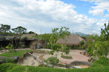
This bioparque is an educational and conservation proposal for Colombia and the world, created with the idea "the animal and its surroundings", with this motto is intended to break the stereotypes of Victorian zoos with enclosures for animals of the prison type. The Ukumari Bioparc opened its doors on June 30, 2015, the last day of June began the official transfer of animals from the traditional zoo Matecaña (recently closed) to the forests of Ukumarí. Weeks ago some species of birds and mammals had arrived. In its opening it will offer only a bioregion (the Andean forest), which in our country houses 69% of the national birds, which will be an important sample of this bioregion. Additionally, the bioparque is under construction by six other bioregions, three with exotic animals (which generate the highest demand for visitors, as are species from Africa and Asia) and four other bio-regions of the Colombian territory.
For the beginning phase of the tests and transfer of animals from the bioparque, where the area of the Andean Forest was inaugurated, 80 billion pesos were invested, distributed in halves between the National Government, headed by the Ministry of Industry, Commerce and Tourism; And the INFIPEREIRA. The lifting of land and adaptation of the land where the bioparque takes place, had a cost of 30 billion pesos. In conclusion, 110 billion pesos was the total investment for the first phase of construction.12
Ukumarí is expected to become a development engine for Pereira and a new opportunity to catapult tourism in the region. As the last administrations of Pereira have pointed out for more than a decade, this project will be the best complement to the offer of the coffee axis and, along with Matecaña International Airport, a new pride of 'the querendona, trasnochadora and morena'.
Places of Interest
- Technological University of Pereira, (planetarium and botanical garden of Pereira Technological University and Guaducto, a bamboo bridge).[1]
- Cathedral of Our Lady of Poverty.
- Lucy Tejada, cultural centre.
- Pereira Museum of Art
- Jaime Mejia archaeological museum
- Sanctuary of Our Lady of Fatima.
- Consota Recreational Park: Noah's farm eco-park, water park
- Olympic venues: village, pools, tennis courts, basketball courts and velodrome.
- Los Nevados National Natural Park
- Botanical Garden of Marseille
- Plaza de Bolívar and the naked Bolívar statue.[6]
- Circunvalar Avenue, high end shopping boulevard
- Victoria's City Square
- Parque Arboleda Shopping mall
- Unicentro or Unicenter, the largest mall in the Coffee Axis
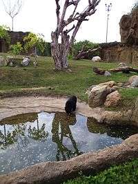 Bears at the Ukumarí Biopark.
Monuments
- Monument to the founders, Rodrigo Arenas Betancur
- Prometheus bound, Universidad Tecnológica de Pereira, Rodrigo Arenas Betancur.
- Christ without the cross, Our Lady of Fatima church, Rodrigo Arenas Betancur.
- The Rebecca, Circunvalar park, Cardigan Ave., Larry Mendez.
- Train: monument of transport", transportation terminal.
- Alexandra Ariza, Jorge Eliecer Gaitan park, opposite the St. George hospital, Jorge Eliecer Gaitan
- The Obelisk, Hernando Hoyos.
- Diana of the Gavi and the young of Jar.
- General Rafael Uribe Uribe, Franco A. Cano.
- The Traveler, Antonio Segui.
Architecture

In the city center you can see different buildings, dominated by the republican style buildings of few floors, in the Ciudad Victoria, you can see from buildings modern style to colonial style (being very few), being the area covered by the center, Ciudad Victoria, and Av. Circunvalar, historical, modern, economic and commercial center of the city.
The reconstruction of the old gallery sector is the largest project of social and economic renewal has been made in the city. Since the early 80s he began to speak in Pereira of the need for action renewal in the area due to the deterioration of this sector. Through the figure of the Urban Renewal municipality allowed the development of what is now Ciudad Victoria (Pereira) | Ciudad Victoria, which has varied public spaces, among which the Plaza de Bolivar, located in the streets 19 and 20, between Seventh and Eighth races, opposite the Cathedral of Our Lady of Poverty, it is famous for its Naked Bolivar monument. The area is the main center of commercial and financial activities of the city as well as a meeting place for its inhabitants.
There is also the Lucy Tejada Cultural Center, located at the site of the central gallery, where the Cultural Institute of Pereira is located, the Band, the Issuer "Remigio Antonio Cañarte", the station Pereira Air, the Municipal Library, Exhibition Hall and the headquarters of the Academy of History from Pereira, music workshops, theater and dance and shops related to the cultural theme. It was opened in 2005 on the occasion of the celebrations of the city.14 anniversarias For a more direct communication between Ciudad Victoria and industry Avenue Circunvalar there flyover, a bridge that allows two-way connection, both pedestrian level as ciclorruta.
The most important stage of concerts, artistic performances and core of the cultural life of Pereira, is the Teatro Municipal Santiago Londoño, which pays tribute to one of its most prominent mecenas15. The city also has the Library and Exhibition Centre, Bank of the Republic and the Museum of Modern Art, the latter with modern exhibition halls and auditorium. Pereira is considered one of the cities with the best infrastructure in the country.
Victoria has the Egoyá Linear Park between Calles 14 and 18, with 0.6 ha of parkland. Its name comes from the old broken, now underground, Egoyá through the center of the city. On the other hand, the Civic Plaza Ciudad Victoria is where the main events and festivals in the city are made.
Among the most representative works of the city they are:
- Naked Bolivar: Rodrigo Arenas Betancourt. Bolivar plaza.
- Monument to the Founders: Rodrigo Arenas Betancourt. Carrera 13 with Calle 12.
- Chained Prometheus: Rodrigo Arenas Betancourt. Technological University of Pereira.
- Without Christ Cross: Rodrigo Arenas Betancourt. Church of Our Lady of Fatima.
- Rebeca: Leonidas Mendez. Park Avenue Cardigan Circunvalar.
- Railway: Monument to Transport. Waterfront Transport Terminal.
- Jorge Eliecer Gaitan: Alexandra Ariza. Jorge Eliecer Gaitan Park, opposite the San Jorge Hospital.
- The Obelisk: Hernando Hoyos. Calle 17 with carrera 6.
- General Rafael Uribe Uribe: A. Franco Cano. Park Lake.
- The Traveler: Antonio Segui. August 30 avenue, roundabout Cuba.
Transportation
Air
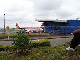
Pereira's airport is the Matecaña International Airport. It was built between 1944 and 1946 and opened in August 1947. It operates both nationally and internationally. It is currently undergoing a large expansion which will include a new control tower, a longer runway, new access roads and new destinations such as New York, which will make Matecaña International Airport one of the most important of the country. In 2016, the airport has launched the tendering process for the construction of the new terminal building. Also both runway expansions hace been completed as well as the new control tower, the most modern and technological control tower in the country. Also the Zoo has moved out of Matecaña Zoo and has been moved to the new Biopark Ukumari, this means these lands have been given to the Airport to use for more expansion to is access road and an Office and Hotel Complex.
Road
Pereira is at the center of the transport hub for Caldas, Risaralda and Quindio. Autopista del Café are the highways which connect Armenia, Manizales, Pereira and Cartago. (Coffee Freeway).[7] Other main urban highways include: 30 August Avenue, Circunvalar Avenue, The Americas Avenue, The Railway Avenue, Belalcazár Avenue, The River Avenue and streets Sixth, Seventh and Eighth and other highways. Pereira street system is aligned in grid system, with road numbers going up in carreras from the River Otun, and street number going up from the neighbourhood Alfonso Lopez. It is important to note that beyond Alfonso Lopez, the streets become affixed with a letter E, to denote East, for example the Kennedy neighourhood is completely composed of streets like Street 7E, Street 10E and so on.
SITM or Mass Public Transport
Pereira is currently undergoing a transitional phase, in which the traditional buses of the city are replaced completely by a Mass Public Transportation system with a Cable Car system.
Urban Bus
Soon to be replaced, is a bus system which has almost 50 routes in the city, which has a cost of $2.000 which is paid directly to the driver in cash, which has coverage in most areas of the city.
Cable Car
Part of the new development plan of the new mayor Juan Pablo Gallo M is to build 3 new lines of Cable cars across the city. Currently the Mexican transportation consultants Transconsult are investigating which are the most viable routes and locations for the cable car. It has been announced that the possible route can be from Industrial Park (Parque industrial) to the Airport, Villa Santana to the UTP University and Villa Verde to the City Center. Construction on the first line is scheduled to commence ending 2016 or the first month of 2017.
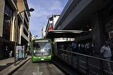
Megabus
Megabús is the mass transport system of Pereira which was founded in 2006. It comprises 3 trunk routes that link Dosquebradas and Cuba, and feeder routes which connect the rest of the metropolitan area including La Virginia, Puerto Caldas, Cerritos, Morelia, and many other neighbourhoods, which connect with the trunk routes at Interchanger stations. Since 2016, Megabus has embarked on the task of connecting the entire city, with new routes to important areas of the city that before didn't have a Megabus route. One of these new routes is to the UTP University vía The Américas Avenue and the Transport Station.
Cesar Gaviria Trujillo Viaduct

The architectural award winning César Gaviria Trujillo Viaduct, a cable-stayed bridge, was opened on 15 November 1997. It is named after César Gaviria, the 40th president of Colombia, who was born in the city of Pereira. The viaduct links Pereira with Dosquebradas and the cities of Armenia, Pereira and Manizales. The length of its centre span is 211 metres (692 ft), one of the longest in South America.[8]
Climate
Pereira is located in a warm moorland area. The average temperature is 22 °C (72 °F). The annual average rainfall is 2,750 millimetres (108 in). There is a large degree of biodiversity in the region.
| Climate data for Pereira, Colombia (Matecaña International Airport) 1981–2010 | |||||||||||||
|---|---|---|---|---|---|---|---|---|---|---|---|---|---|
| Month | Jan | Feb | Mar | Apr | May | Jun | Jul | Aug | Sep | Oct | Nov | Dec | Year |
| Record high °C (°F) | 35.5 (95.9) |
37.0 (98.6) |
36.0 (96.8) |
36.0 (96.8) |
33.5 (92.3) |
34.0 (93.2) |
33.5 (92.3) |
37.0 (98.6) |
36.8 (98.2) |
36.2 (97.2) |
34.0 (93.2) |
36.0 (96.8) |
37.0 (98.6) |
| Average high °C (°F) | 26.8 (80.2) |
27.1 (80.8) |
26.9 (80.4) |
26.2 (79.2) |
25.9 (78.6) |
26.0 (78.8) |
26.5 (79.7) |
26.9 (80.4) |
26.4 (79.5) |
25.8 (78.4) |
25.6 (78.1) |
26.0 (78.8) |
26.3 (79.3) |
| Daily mean °C (°F) | 21.8 (71.2) |
22.0 (71.6) |
21.9 (71.4) |
21.5 (70.7) |
21.4 (70.5) |
21.5 (70.7) |
21.7 (71.1) |
22.0 (71.6) |
21.5 (70.7) |
20.9 (69.6) |
20.9 (69.6) |
21.4 (70.5) |
21.5 (70.7) |
| Average low °C (°F) | 17.4 (63.3) |
17.5 (63.5) |
17.6 (63.7) |
17.6 (63.7) |
17.6 (63.7) |
17.4 (63.3) |
17.2 (63) |
17.2 (63) |
17.1 (62.8) |
17.0 (62.6) |
17.2 (63) |
17.4 (63.3) |
17.4 (63.3) |
| Record low °C (°F) | 11.0 (51.8) |
10.0 (50) |
11.0 (51.8) |
11.0 (51.8) |
10.0 (50) |
10.0 (50) |
11.0 (51.8) |
10.0 (50) |
10.0 (50) |
10.0 (50) |
10.0 (50) |
10.0 (50) |
10.0 (50) |
| Average precipitation mm (inches) | 132.7 (5.224) |
132.6 (5.22) |
220.2 (8.669) |
249.3 (9.815) |
257.4 (10.134) |
196.1 (7.72) |
133.5 (5.256) |
129.0 (5.079) |
195.9 (7.713) |
290.5 (11.437) |
287.9 (11.335) |
199.4 (7.85) |
2,424.4 (95.449) |
| Average precipitation days | 16 | 15 | 20 | 23 | 24 | 21 | 20 | 18 | 21 | 24 | 23 | 20 | 243 |
| Average relative humidity (%) | 75 | 74 | 76 | 79 | 79 | 78 | 75 | 74 | 76 | 79 | 79 | 77 | 77 |
| Mean monthly sunshine hours | 186.0 | 161.0 | 155.0 | 132.0 | 139.5 | 147.0 | 182.9 | 182.9 | 150.0 | 142.6 | 150.0 | 167.4 | 1,896.3 |
| Mean daily sunshine hours | 6.0 | 5.7 | 5.0 | 4.4 | 4.5 | 4.9 | 5.9 | 5.9 | 5.0 | 4.6 | 5.0 | 5.4 | 5.2 |
| Source: Instituto de Hidrologia Meteorologia y Estudios Ambientales[9][10][11] | |||||||||||||
Education
Places of learning in Pereira include:
- Technological University of Pereira
- Universidad Católica de Pereira
- The Liberty University of Colombia
- Andina University
- Cooperative University of Colombia
- National University of Colombia distance learning campus
- Saint Thomas Aquinas University campus
- CEIPA University,
- Antonio Nariño University
- Autonomous University of the Americas.
Pereira also has a number of training institutions associated with the National Learning Service (SENA).
Fiesta de la Cosecha
The Harvest Festival (Spanish: Fiesta de la Cosecha) is celebrated on the anniversary of the founding of the city. It has led to phrases such as "asi no vamos a llegar a ningún Pereira" ("This way, we'll never get to Pereira", meaning "this is useless") and "hicieron su Agosto" ("they made their August", meaning that someone made a really good deal, referring to the belief that everyone would sell all their merchandise at the festival of Pereira).[12]
Sports
Pereira has a huge variety in sport arenas in the city. It has the biggest and best Olympic Village in the Western part of the Country, with the recently renovated Stadium Hernan Ramirez Villegas, the Velodrome, the Olympic swimming pools, the multiple tennis and synthetic football fields, and the biggest Skate Park in the Country. It also has many other venues like the Commerce Club with many more venues.
Pereira has achieved the title of the most active city in Colombia in 2015, with important programs such as the Cycle way every Sunday, by closing the most important avenues of the city to give way for people riding bike, running or simply walking. Also every neighbourhood in the city has an Open Air gym for the use of everyone.
Pereira's main football team is the Deportivo Pereira, which plays in the Categoría Primera B. The city hosts the Hernán Ramírez Villegas stadium, a velodrome, a skating area, an Olympic swimming pool and a motocross track. Pereira is also home to the "coffee marathon". Pereira is the birthplace of the Colombian tennis player, Santiago Giraldo.
Religion
The predominant religion is Catholicism. There are also Protestant churches.
Twin towns – Sister cities
Pereira is twinned with:
Gastronomy
Pereira's gastronomy is rich since its climate allows a great variety of fruits and vegetables to be grown. Pereira makes part of the coffee region as well as it is one of the paisas cities. Therefore, the main dishes are influenced by the paisa culture and by regions near to it. The main dishes are: the Sancocho soup, which is a soup made with chicken and beef meat, with potato, yuca, corn, sweet plantain and rice. Other main dish is bandeja paisa, which has black beans with rice, fried sweet plantain, avocado, fried egg, sausages and meat. Mazamorra, is another typical dish that is served as dessert, its made of smashed corn with milk, and sweet unprocessed sugar, in Spanish panela, is added to it.
Apart from the typical plates, pereira offers a great variety of pineapple, oromiel. And small biscuits called panderos, which are made of panela (unprocessed sugar cane) .
Gallery
 El Lago Uribe Uribe Park
 Bolívar Plaza
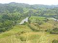 Rio de La Vieja (Old Lady River)
.jpg) Lions from the Matecaña Zoo
Lions from the Matecaña Zoo
See also
- 1999 Armenia earthquake
- César Gaviria Trujillo Viaduct
- Matecaña City Zoo
- Technological University of Pereira
- Deportivo Pereira
References
- 1 2 "Colombia green guide Michelin 2012-2013." Michelin. 2012. Accessed at Google Books 29 December 2013.
- ↑ Sharpless R. E. "Gaitán of Colombia: a political biography." University of Pittsburgh 1978 p16. ISBN 0822976196, 9780822976196. Accessed at Google Books 29 December 2013.
- 1 2 Palacios M. "Coffee in Colombia, 1850-1970: an economic, social and political history." Cambridge University Press, 25 July 2002. p162. ISBN 0521528593, 9780521528597. Accessed at Google Books 29 December 2013.
- ↑ Hudson R. A. "Colombia, a country study." Government Printing Office, Library of Congress, USA. p95 ISBN 016088277X, 9780160882777.
- ↑ Toasa J. "Colombia: a new ethanol producer on the rise?" Diane publishing and Department of Agriculture, Economic Research Service, USA 2009 p4. ISBN 1437923674, 9781437923674. Accessed at Google Books 29 December 2013.
- ↑ Duncan R. J. "The Ceramics of Ráquira, Colombia: Gender, Work, and Economic Change." University Press of Florida, 1998. p93. Accessed at Google Books 29 December 2013.
- ↑ "En servicio calzada de la Autopista del Café." Eldiario website. Accessed 1 February 2013.
- ↑ "Cesar Gaviria Trujillo Viaduct." Structurae, International database and gallery of structures. Website in English. Accessed 30 December 2013.
- ↑ "Promedios Climatológicos 1981–2010" (in Spanish). Instituto de Hidrologia Meteorologia y Estudios Ambientales. Archived from the original on 14 August 2016. Retrieved 16 August 2016.
- ↑ "Promedios Climatológicos 1971–2000" (in Spanish). Instituto de Hidrologia Meteorologia y Estudios Ambientales. Archived from the original on 14 August 2016. Retrieved 16 August 2016.
- ↑ "Tiempo y Clima" (in Spanish). Instituto de Hidrologia Meteorologia y Estudios Ambientales. Archived from the original on 14 August 2016. Retrieved 16 August 2016.
- ↑ "Harvest Festivals." Colombia Festiva website, in English, 2011. Accessed 30 December 2013.
External links
| Wikivoyage has a travel guide for Pereira. |
- Official website. (Spanish)
- Megabús' official website. (Spanish)
- Pereira. (Spanish)
- Universidad Tecnologica.
- Portal of Pereira city. (Spanish)
- Constructora líder en Pereira y Risaralda. (Spanish)
Municipalities in the Risaralda Department | ||
|---|---|---|