Potter, Kansas
| Potter, Kansas | |
|---|---|
| Unincorporated community | |
 Potter, Kansas  Potter, Kansas | |
| Coordinates: 39°25′33″N 95°08′31″W / 39.42583°N 95.14194°WCoordinates: 39°25′33″N 95°08′31″W / 39.42583°N 95.14194°W | |
| Country | United States |
| State | Kansas |
| County | Atchison |
| Elevation | 965 ft (294 m) |
| Time zone | Central (CST) (UTC-6) |
| • Summer (DST) | CDT (UTC-5) |
| Area code(s) | 913 |
| GNIS feature ID | 478256[1] |
Potter is an unincorporated community in Atchison County, Kansas, United States. Potter is located on K-74 9.5 miles (15.3 km) south of Atchison.
History
Potter had its start in the year 1886 by the building of the railroad through that territory.[2][3] It was named for Joseph Potter, a pioneer settler.[4]
Potter had a post office with ZIP code 66077, which opened on May 14, 1865, and closed on May 16, 2009.[5]
References
- ↑ "Potter". Geographic Names Information System. United States Geological Survey.
- ↑ Blackmar, Frank Wilson (1912). Kansas: A Cyclopedia of State History, Volume 2. Standard Publishing Company. p. 493.
- ↑ Ingalls, Sheffield (1916). History of Atchison County, Kansas. Standard Publishing Company. p. 123.
- ↑ Ingalls, Sheffield (1916). History of Atchison County, Kansas. Standard Publishing Company. p. 124.
- ↑ "Postmaster Finder - Post Offices by ZIP Code". United States Postal Service. Retrieved November 10, 2011.
Municipalities and communities of Atchison County, Kansas, United States | ||
|---|---|---|
| Cities | 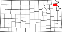 | |
| Unincorporated communities | ||
| Indian reservations | ||
| Townships | ||
| Ghost towns | ||
| Footnotes | ‡This populated place also has portions in an adjacent county or counties | |
This article is issued from Wikipedia - version of the 10/25/2016. The text is available under the Creative Commons Attribution/Share Alike but additional terms may apply for the media files.