Port Wing, Wisconsin
| Port Wing, Wisconsin | |
|---|---|
| Census-designated place | |
 | |
 Port Wing | |
| Coordinates: 46°46′29″N 91°23′12″W / 46.77472°N 91.38667°WCoordinates: 46°46′29″N 91°23′12″W / 46.77472°N 91.38667°W | |
| Country | United States |
| State | Wisconsin |
| County | Bayfield |
| Town | Port Wing |
| Area | |
| • Total | 1.150 sq mi (2.98 km2) |
| • Land | 1.150 sq mi (2.98 km2) |
| • Water | 0 sq mi (0 km2) |
| Elevation | 676 ft (206 m) |
| Population (2010) | |
| • Total | 164 |
| • Density | 140/sq mi (55/km2) |
| Time zone | Central (CST) (UTC-6) |
| • Summer (DST) | CDT (UTC-5) |
| ZIP code | 54865 |
| Area code(s) | 715 and 534 |
| GNIS feature ID | 1571798[1] |
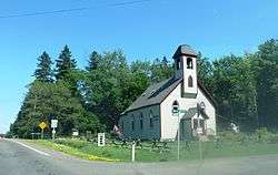
Port Wing (also Portwing) is an unincorporated census-designated place in the town of Port Wing, Bayfield County, Wisconsin, United States.[1][2] The community is located on Wisconsin Highway 13, 30 miles (48 km) west of Bayfield. The Flagg River enters Lake Superior at Port Wing's harbor.[3]
Population
As of the 2010 census, its population is 164.[4] Port Wing has an area of 1.150 square miles (2.98 km2), all of it land.
Education
Port Wing is the site of South Shore School District.[5]
Notable people
- Gary Sherman, politician and jurist, lived in Port Wing.[6]
Notes
- 1 2 "Port Wing, Wisconsin". Geographic Names Information System. United States Geological Survey.
- ↑ Hometownlocator.com
- ↑ Wisconsin Department of Transportation-Bayfield County, Wisconsin
- ↑ "American FactFinder". U.S. Census Bureau. Retrieved 19 April 2011.
- ↑ South Shore School District
- ↑ Votesmart.org.-Gary Sherman
External links
Municipalities and communities of Bayfield County, Wisconsin, United States | ||
|---|---|---|
| Cities | 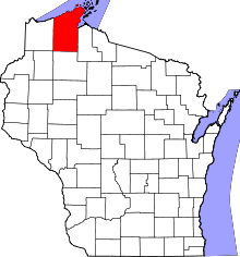 | |
| Village | ||
| Towns | ||
| CDPs | ||
| Unincorporated communities | ||
| Indian reservation | ||
| Footnotes | ‡This populated place also has portions in an adjacent county or counties | |
This article is issued from Wikipedia - version of the 9/9/2015. The text is available under the Creative Commons Attribution/Share Alike but additional terms may apply for the media files.