Pomme de Terre River (Missouri)
| Pomme de Terre River | |
| Potato River | |
| Country | United States |
|---|---|
| State | Missouri |
| Source | |
| - location | Marshfield, Missouri |
| - elevation | 1,454 ft (443 m) |
| - coordinates | 37°20′24″N 92°56′43″W / 37.34000°N 92.94528°W |
| Mouth | Truman Reservoir |
| - location | Hickory County, Missouri |
| - elevation | 709 ft (216 m) |
| - coordinates | 38°00′35″N 93°18′59″W / 38.00972°N 93.31639°WCoordinates: 38°00′35″N 93°18′59″W / 38.00972°N 93.31639°W [1] |
| Length | 130 mi (209 km) |
| Basin | 840 sq mi (2,176 km2) |
| Discharge | for USGS 06921350 near Hermitage, MO[2] |
| - average | 546 cu ft/s (15 m3/s) |
| - max | 9,000 cu ft/s (255 m3/s) |
| - min | 0 cu ft/s (0 m3/s) |
| Watersheds | Pomme de Terre-Osage-Missouri-Mississippi |
| Reservoirs | Pomme de Terre Lake, Truman Reservoir |
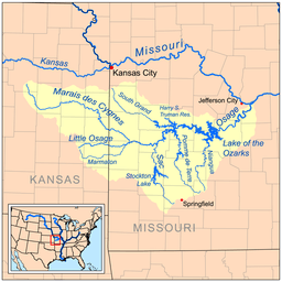 Map of the Osage River watershed showing the Pomme de Terre River | |
The Pomme de Terre River (pronounced pohm de TEHR) is a 130-mile-long (210 km)[3] tributary of the Osage River in southwestern Missouri in the United States. Via the Osage and Missouri rivers, it is part of the watershed of the Mississippi River.
Pomme de terre is French for potato, an food Indians harvested in the area.[4] Before the French explorers, the Osage people, who were historically indigenous to the region, had called it a name meaning Big Bone River, referring to the fossils of mastodons and other ancient creatures which they found along its eroding banks.[5]
Course
The Pomme de Terre River is formed in Greene County in the Ozarks by the confluence of its short north and south forks, which rise in Webster and Greene counties, respectively. The river flows generally northward through Dallas, Polk, Hickory and Benton counties, past the town of Hermitage. In Polk County it collects the short Little Pomme de Terre River, which rises in Greene County and flows generally northwestwardly. In Hickory County a U.S. Army Corps of Engineers dam causes the river to form Pomme de Terre Lake. It enters the Osage River as an arm of Truman Lake, which is formed by a dam on the Osage.
See also
References
- ↑ "Pomme de Terre River". Geographic Names Information System. United States Geological Survey. Retrieved 2015-12-04.
- ↑ "Water-Data Report 2013 - 06921350 Pomme de Terre River near Hermitage, MO" (PDF). Retrieved 2015-12-04.
- ↑ U.S. Geological Survey. National Hydrography Dataset high-resolution flowline data. The National Map, accessed May 31, 2011
- ↑ "Hickory County Place Names, 1928–1945 (archived)". The State Historical Society of Missouri. Retrieved 6 October 2016.
- ↑ Adrienne Mayor, "Place names describing fossils in oral traditions", Stanford University, pp. 253-254, c. 2005, accessed 9 December 2011
- Columbia Gazetteer of North America entry
- DeLorme (2002). Missouri Atlas & Gazetteer. Yarmouth, Maine: DeLorme. ISBN 0-89933-353-2.