Pollard, Kansas
| Pollard, Kansas | |
|---|---|
| Unincorporated community | |
 | |
 Pollard, Kansas  Pollard, Kansas | |
| Coordinates: 38°26′59″N 98°12′38″W / 38.44972°N 98.21056°WCoordinates: 38°26′59″N 98°12′38″W / 38.44972°N 98.21056°W | |
| Country | United States |
| State | Kansas |
| County | Rice |
| Township | Victoria |
| Elevation | 1,739 ft (530 m) |
| Time zone | Central (CST) (UTC-6) |
| • Summer (DST) | CDT (UTC-5) |
| Area code(s) | 620 |
| GNIS feature ID | 484741[1] |
Pollard is an unincorporated community in Victoria Township, Rice County, Kansas, United States. It lies a fraction of a mile (about 1 km) west of K-14, 6 miles (9.7 km) southwest of Geneseo and 7 miles (11 km) north of Lyons,[2] the county seat of Rice County.[3]
History
For millennia, the land now known as Kansas was inhabited by Native Americans. In 1803, most of modern Kansas was secured by the United States as part of the Louisiana Purchase. In 1854, the Kansas Territory was organized, then in 1861 Kansas became the 34th U.S. state. In 1867, Rice County was founded.
Pollard had a post office from 1888 until 1923.[4]
References
- ↑ "US Board on Geographic Names". United States Geological Survey. 2007-10-25. Retrieved 2008-01-31.
- ↑ DeLorme. Kansas Atlas & Gazetteer. 4th ed. Yarmouth: DeLorme, 2009, p. 47. ISBN 0-89933-342-7.
- ↑ "Find a County". National Association of Counties. Retrieved 2011-06-07.
- ↑ "Kansas Post Offices, 1828-1961". Kansas Historical Society. Archived from the original on October 9, 2013. Retrieved 22 June 2014.
Further reading
See also: List of books about Rice County, Kansas
Municipalities and communities of Rice County, Kansas, United States | ||
|---|---|---|
| Cities | 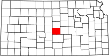 | |
| Unincorporated communities | ||
| Townships | ||
This article is issued from Wikipedia - version of the 8/23/2016. The text is available under the Creative Commons Attribution/Share Alike but additional terms may apply for the media files.