Polbrock
Coordinates: 50°29′28″N 4°48′07″W / 50.491°N 4.802°W
Polbrock (Cornish: Polbrogh, meaning badger's pool[1]) is a small hamlet in north Cornwall, England, United Kingdom. It is situated two miles southeast of Wadebridge at grid reference SX 014 695 and near Burlorne Pillow.
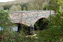
Polbrock is situated in the steep-sided and heavily wooded valley of the River Camel and is the site of a bridge carrying a minor road over the river. The bridge is the first crossing of the River Camel upstream of Wadebridge; the next crossing is at Nanstallon two miles further upstream.[2]
Polbrock is on the Camel Trail long-distance footpath and cycle trail. At this point, the Camel Trail follows the trackbed of the former Bodmin and Wadebridge Railway).[3][4]
Polbrock is the first road access point to the Camel Trail when travelling from Wadebridge towards Bodmin.[5] There is a small car park and picnic area from which a footpath leads through Bishop's Wood to Hustyn Mill.
References
- ↑ Weatherhill, Craig (2009). A Concise Dictionary of Cornish Place-Names. Westport, Co. Mayo: Evertype. ISBN 9781904808220; p. 56
- ↑ Ordnance Survey 'Landranger' 1:50000 map, sheet number 200
- ↑ Sustrans Camel Trail web page
- ↑ North Cornwall District Council's Camel Trail website
- ↑ NCDC Camel Trail guide leaflet
External links
![]() Media related to Polbrock at Wikimedia Commons
Media related to Polbrock at Wikimedia Commons
Cornwall Portal | |
| Unitary authorities | |
| Major settlements |
|
| Rivers | |
| Topics | |