Florida State Road 538
| |
|---|---|
| Poinciana Parkway | |
| Route information | |
| Maintained by OCX | |
| Length: | 10 mi (16 km) |
| Existed: | April 30, 2016 – present |
| Major junctions | |
| West end: |
|
| East end: |
|
| Location | |
| Counties: | Polk, Osceola |
| Highway system | |

The Poinciana Parkway, also known as Florida State Road 538,[1] is an approximately 10-mile (16 km) toll road built in Osceola & Polk Counties in Florida. The road has been planned for decades to provide a traffic outlet from Poinciana northwest to US 17/US 92 and Interstate 4. Costs skyrocketed after land the road would traverse was turned into a mitigation bank, requiring a bridge to span most of the 1.2 miles (1.9 km) stretch of the Poinciana Parkway through the restored wetland. The road was originally planned to be built by Avatar—the primary developer of Poinciana—as a four-lane, limited-access highway, with the section across the mitigation bank tolled after the decision to build the bridge, but the collapse of the 2000s housing bubble and increased costs forced Avatar to abandon their plans to build the private toll road. About the same time Osceola County formed the Osceola County Expressway Authority to build a loop road around the Kissimmee-St.Cloud area, which would include the Poinciana Parkway. Construction began in 2013 and was completed in 2016.
Route description

The Poinciana Parkway is a two-lane toll road running between US 17/US 92 in Loughman and the Cypress Parkway (CR 580)[lower-alpha 1] in Poinciana, with a large section crossing undeveloped swampland. The road was constructed as a two-lane, grade-separated highway, but is designed to be expanded to a four-lane expressway.[3]
The road begins at the intersection of US 17/92 with the Ronald Reagan Parkway[lower-alpha 1] (former County Road 54) to the northwest and Kinney Harmon Road to the southeast. The Ronald Reagan Parkway provides indirect access from the Poinciana Parkway to Interstate 4.[2] From the intersection, the Poinciana Parkway travels southeast along the existing Kinney Harmon Road, which was previously a minor residential arterial road. The road passes through the Reedy Creek Mitigation Bank—a conserved area of wetlands—where it crosses a bridge just over one mile (1.6 km) in length.[4][5] The crossing of the swamp includes long bridges[3] and a turn to the south. South of the bridge, the parkway has intersections with Marigold Avenue, KOA Street, and a T-intersection with Cypress Parkway. Toll gantries will be located between the RCMB bridge and Marigold Avenue and between Marigold Avenue and KOA Street; all tolls will be collected electronically by overhead gantries and SunPass transponders.[6]
History
The Poinciana Parkway is a long-conceived road to provide access on the northwest side of the planned urban development of Poinciana. The first plans for the new community were made around 1970 to develop tens of thousands of acres of rural land along the border between Osceola and Polk Counties. Developers envisioned a bedroom community of 250,000, minutes away from jobs and entertainment (plans to build nearby Disney World were announced in 1966).[7][8] In the past, the proposed highway has also been called the "Parker Highway Project"[9]:1 and "Parker-Poinciana Highway".[8]
However, development proceeded slowly through the 1980s and early 1990s, in part due to inadequate planning. One significant problem that has limited development is limited road access to the area; Poinciana is surrounded by extensive wetlands and lakes with few arterial roads leading out of the community.[7] In the late 1970s, Polk County built an unrelated road also named "Poinciana Parkway" leading south and the Cypress Parkway was built leading west to Haines City. In 1981, Poinciana Boulevard was extended to US 192 to improve access to I-4 and Kissimmee. In 1998, Pleasant Hill Boulevard was widened to four lanes.[7] In the 2000s, a housing boom led to a huge increase in the town's population, from 13,647 in 2000 to 53,193 in 2010. Because Poinciana was planned as a bedroom community, improved road access is seen as essential to the community's future; the average commute is 45 minutes, which is among the highest commute times for small cities in the US.[7]
Avatar—one of the main developers of Poinciana—had long planned to connect Kinney Harmon Road with the Cypress Parkway in order to relieve congestion along Poinciana and Pleasant Hill Boulevards.[7] However, the highway would not be built until the company was able to develop the community according to plan. Despite being included in the comprehensive land use plans of both Polk and Osceola Counties, the Polk County Commission voted in 1997 to vacate right-of-way along Kinney Harmon Road to a developer to build a 495-lot mobile home park, a move that would effectively block construction of the Poinciana Parkway.[8][10] The commissioners noted that the road had been discussed for years, but there were still no plans to build it at the time.[10] Avatar sued the county and the 10th Judicial Circuit ruled that the commissioners did not explain why vacating the right-of-way would be in the public interest when making their decision.[8] Osceola County had objected the commissioners' decision and helped Avatar in the case, but did not join the lawsuit.[8]

In 1994, Avatar spent $1.5 million for a conceptual permit from the South Florida Water Management District and also received permission from the US Army Corps of Engineers to construct a road across wetland to the northwest of Poinciana, even though they did not own that land at the time.[11][5] In 1997, private investors received a permit from SFWMD to establish the Reedy Creek Mitigation Bank (RCMB) in the same area. The RCMB is a 3,500-acre (1,400 ha) mitigation bank to restore wetlands, which would then be protected in perpetuity by state and federal law.[11][12] The investors receive credits from the state for restoring and protecting the wetlands. Developers purchase the credits to offset the destruction of wetlands elsewhere.[11] The Poinciana Parkway would cross 1.2 mi (1.9 km) of the RCMB.[5]
The establishment of the RCMB despite previous plans for the road became a barrier to the Poinciana Parkway's construction. There was concern of setting a precedent of allowing development in conservation areas that are supposed to be protected from development. In order to preserve the wetland habitat, officials wanted a bridge over the wetland habitat, while Avatar contended that bridging the wetland would be too expensive and proposed short bridges or culverts for water and animals to pass.[11][12] In 2008, the Army Corps of Engineers determined that the road could only be built if it included two 2,000 ft (610 m) bridges, adding $20–40 million to the project's cost or remove the land north of the wetlands from the bank, compensating the bank's owners. The Corps also considered other alignments that would avoid the bank, but concluded that they were worse logistically, environmentally, or traffic-wise.[5]
In 1997, the highway was estimated to cost $8 million to connect the end of Kinney Harmon Road with the end of Marigold Avenue. The RCMB saga skyrocketed cost estimates to construct the four-lane highway from $22 million in 2004 to $140–200 million in 2008.[13] Avatar planned to build 10 miles (16 km) of road, retaining 4.15 mi (6.68 km) of the highway to operate as a toll road and donate the rest to Osceola County. In early 2008, Avatar planned to build the highway in 2009.[13] Avatar had originally planned to construct a four-lane divided expressway within a right-of-way that would allow expansion to a six-lane expressway with a frontage road. The company had also planned to convert Marigold Avenue into a limited-access road as part of the Poinciana Parkway project.[3]
However, the 2000s housing bubble that drove significant growth of Poinciana collapsed and Avatar was unable to justify the costs or finance construction of the highway.[3] Around 2010, Avatar decided not to build the highway while at the same time, the state established the Osceola County Expressway Authority (OCX) to develop and built a series of toll road segments in Osceola County. The 2040 Master Plan developed by OCX has a loop route around the south and east sides of the Kissimmee-St.Cloud area. The Poinciana Parkway is a natural part of the proposed loop road.[3]
In 2012, an agreement was reached between Orange County, Polk County, OCX, and Avatar to construct the highway. Avatar donated approximately $48 million worth of right-of-way, studies/engineering work, construction plans, and permits[9]:15–24 and gave Polk County a 9.8-acre (4.0 ha) parcel of land designated as a "public safety site" (future fire station and communications tower).[9]:35 Osceola County will provide $6 million and cover any shortfall between the cost of construction and the sale of bonds plus Polk County's contribution.[9]:34 Polk County will contribute $6 million to the project (of which $3 million was to be reimbursed by FDOT),[14] but will not be obligated to contribute to any further expansion of the highway.[9]:34–35
Construction
Soon after its establishment, OCX decided to limit construction costs to $70 million,[15] a figure which is in addition to approximately $50 million of plans, permits, and right-of-way donated by Avatar, who will not be reimbursed. Because of the cost limit, a two-lane highway is being built initially, using a design that will easily permit the road to be widened to a four- or six-lane expressway in the future. In July 2013, a $68.8 million design-build contract for the highway was awarded to Jr. Davis Construction Company, based in Kissimmee.[16][6]
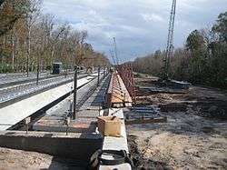
The second-place bidder, Lane Construction Corporation, sued OCX after an appeal of the decision was rejected by the OCX board. Lane alleged that scoring of the bids were improperly skewed in Jr. Davis' favor and that the latter was not properly licensed. Lane's bid was cheaper, at $62 million, but OCX determined that the Jr. Davis bridge design was superior.[16] Lane did not succeed with the lawsuit and a notice to proceed, authorizing construction to begin, was issued in December 2013.[6] To construct the bridge, a temporary haul road was constructed across the RCMB.[6] The northern segment of the Poinciana Parkway, from US17/US92 to Marigold Avenue, opened to traffic on April 30, 2016;[1][17] the southern segment of the Poinciana Parkway, from Marigold Avenue to the Cypress Parkway, opened on November 18, 2016.[18]
OCX and financing
The highway is primarily financed by the sale of municipal bonds by OCX, backed financially by Osceola County.[9] About $42 million of the bonds were purchased by Vanguard.[19] Standard & Poor's gave the bonds a BBB- rating, just one level above junk bond status, calling OCX traffic expectations "aggressive."[19][20] The rating may affect the proposed merger of OCX with the Orlando Orange County Expressway Authority (OOCEA). The state legislature has considered merging the two agencies to form a regional expressway authority that would also include Lake and Seminole Counties. OOCEA bonds have identical "A"/"A2" (from Fitch/Moody's) credit ratings[21] and there is concern that the poorly-rated OCX bonds would impact the finances of a combined agency and OOCEA bondholders.[20] The OCX bonds carry a 5.75% interest, while OOCEA's most recent bond sales pay interest rates between 2.37-5.00%.[20] OOCEA chairman Walter Ketcham remarked that the OCX bonds were so poorly rated "we wouldn't touch them with gloves".[20] In 2014, OOCEA became the Central Florida Expressway Authority (CFX).
A $1.75 toll is charged at a toll gantry north of Marigold Avenue to cross the RCMB. An additional $0.50 toll is charged between Marigold Avenue and KOA Street.[20]
Future
The Osceola County Expressway Authority's 2040 master plan includes the Poinciana Parkway in a belt route around the Kissimmee area in northwest Osceola County. Connections to I-4 and Florida's Turnpike are currently undergoing feasibility studies; this would continue around to the east end of the existing Osceola Parkway, including a connection with SR 417 and Orlando International Airport.[3][22]
Major intersections
| County | Location | mi | km | Destinations | Notes | |
|---|---|---|---|---|---|---|
| Polk | | 0.0 | 0.0 | |||
| Osceola | Poinciana | Toll Gantry ($1.75) | ||||
| Marigold Avenue | interchange; eastbound exit and westbound entrance | |||||
| Koa Street | interchange; eastbound exit and westbound entrance | |||||
| Toll Gantry ($0.50) | ||||||
| temporary at-grade intersection | ||||||
| 1.000 mi = 1.609 km; 1.000 km = 0.621 mi | ||||||
Notes
References
- 1 2 Ken Jackson, First Poinciana Parkway leg nears completion, Osceola News-Gazette, March 23, 2016
- 1 2 Google (February 23, 2015). "Florida State Road 538" (Map). Google Maps. Google. Retrieved February 23, 2015.
- 1 2 3 4 5 6 Samuel, Peter (October 2, 2012). "Oseola County FL's Poinciana Parkway after DB, CM, $s for Feb 2013 groundbreak". Toll Roads News. Archived from the original on February 23, 2015. Retrieved February 23, 2015.
- ↑ Breen, David (July 23, 2013). "Work on Poinciana Parkway to start in December". Orlando Sentinel.
- 1 2 3 4 Sashin, Daphne (December 2, 2007). "Army Corps of Engineers' deal gives Avatar OK to build Poinciana Parkway through Orlando-area wetlands". Orlando Sentinel. Retrieved February 24, 2015.
- 1 2 3 4 "Poinciana Parkway January 2015 OCX Board Meeting Progress Report for December 2014" (PDF). Osceola County Expressway Authority. January 2015. Retrieved February 23, 2015.
- 1 2 3 4 5 Palmer, Tom (March 31, 2012). "40 Years of Struggle: Poinciana Eager for a Turnaround". The Ledger. Retrieved February 24, 2015.
- 1 2 3 4 5 Sims, Bob (March 21, 1999). "Legal Hurdles May Block Key Highway In Poinciana". Orlando Sentinel. Retrieved February 25, 2015.
- 1 2 3 4 5 6 "Agreement for development of Poinciana Parkway by and between Osceola County, Florida; Polk County, Florida; Avatar Properties, Inc.; and Osceola County Expressway" (PDF). Polk County Board of County Commissioners. 2012. Archived (PDF) from the original on February 24, 2015. Retrieved February 24, 2015.
- 1 2 Quintana, Craig (April 5, 1997). "Critics: Put Road Back On Map". Orlando Sentinel. Retrieved February 25, 2015.
- 1 2 3 4 Sashin, Daphne (January 9, 2006). "Road leads to conflict of growth, ecology". Orlando Sentinel. Retrieved February 24, 2015.
- 1 2 Mcclure, Vicky; Sashin, Daphne (May 10, 2007). "Toll road may cut at heart of nature". Orlando Sentinel. Retrieved February 24, 2015.
- 1 2 Sashin, Daphne (February 15, 2008). "Road through Orlando-area wetlands is back on track". Orlando Sentinel. Retrieved February 25, 2015.
- ↑ "May 21, 2013 Regular BoCC meeting Agenda Item #9" (PDF). Polk County Board of County Commissioners. May 2013. Archived (PDF) from the original on February 24, 2015. Retrieved February 24, 2015.
- ↑ Breen, David (January 10, 2013). "Poinciana Parkway to cost maximum of $70 million, agency decides". Orlando Sentinel. Retrieved February 25, 2015.
- 1 2 Breen, David (September 16, 2013). "Poinciana Parkway to be delayed by losing bidder's lawsuit". Orlando Sentinel. Retrieved February 25, 2015.
- ↑ Bechara, Stephanie (April 30, 2016). "Poinciana Parkway opens new route between Osceola, Polk Counties". News 13. Retrieved November 29, 2016.
- ↑ Chambliss, John (November 17, 2016). "2nd leg of Poinciana Parkway opens today". Retrieved 23 November 2016.
- 1 2 Campbell, Elizabeth; Chappatta, Brian (June 5, 2014). "Road to Disney World Lures Vanguard as Debt Yields Sink". Bloomberg Business. Retrieved February 25, 2015.
- 1 2 3 4 5 Tracy, Dan; Breen, David (April 29, 2014). "Osceola County building toll road rated a bad risk". Orlando Sentinel. Retrieved February 25, 2015.
- ↑ Sigo, Shelly. "Florida Legislature Pushes Sweeping Toll Road Agency Bill". The Bond Buyer. Retrieved February 25, 2015. (subscription required (help)).
- ↑ Jackson, Ken (January 16, 2015). "Poinciana residents weigh in on Southport Connector to Turnpike". Osceola News-Gazette. Archived from the original on February 23, 2015. Retrieved February 23, 2015.
External links
- Poinciana Parkway webpage about the project from the Osceola County Expressway Authority
- I-4 Poinciana Parkway Connector website about the feasibility study for the connector to I-4
- Southport Conector website about the feasibility study for the Southport Connector to Florida's Turnpike