Pocono Lake, Pennsylvania
| Pocono Lake, Pennsylvania | |
|---|---|
| Unincorporated community | |
 Pocono Lake | |
| Coordinates: 41°06′19″N 75°28′34″W / 41.10528°N 75.47611°WCoordinates: 41°06′19″N 75°28′34″W / 41.10528°N 75.47611°W | |
| Country | United States |
| State | Pennsylvania |
| County | Monroe |
| Township | Tobyhanna |
| Elevation | 1,749 ft (533 m) |
| Time zone | Eastern (EST) (UTC-5) |
| • Summer (DST) | EDT (UTC-4) |
| ZIP codes | 18347, 18350 |
| Area code(s) | 570 and 272 |
| GNIS feature ID | 1184146[1] |
Pocono Lake is an subsection of Pocono Pines, Pennsylvania in Monroe County, Pennsylvania, United States. Pocono Lake is located slightly west of Pocono Pines by Pennsylvania Route 940.
The school district is considered below the state average.[2]
In 2014, economic decline caused an increase in the use of SNAP (Supplemental Nutrition Assistance Program) food stamps throughout the region. According to Rev. Luke Richards, pastor of the Pocono Lake Wesleyan Church, "huge needs" are "ever-changing" in the area.[3]
William Henry Christman, a laborer from Pocono Lake and an enlisted man in the United States Army during the U. S. Civil War, was the first soldier to be buried at Arlington National Cemetery in 1864.[4]
References
- ↑ "Pocono Lake". Geographic Names Information System. United States Geological Survey.
- ↑ "Pocono Lake, PA". USA.com. Retrieved April 21, 2014.
- ↑ Laura Klepacki (April 20, 2014). "At Pocono food pantries, economic recovery is a myth". Pocono Record. Retrieved April 21, 2014.
- ↑ "Arlington National Cemetery Facts About Section 27". Arlington National Cemetery. Retrieved November 25, 2015.
Municipalities and communities of Monroe County, Pennsylvania, United States | ||
|---|---|---|
| Boroughs | 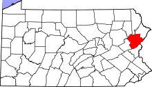 | |
| Townships | ||
| CDPs | ||
| Unincorporated communities |
| |
| Footnotes | ‡This populated place also has portions in an adjacent county | |
This article is issued from Wikipedia - version of the 4/5/2016. The text is available under the Creative Commons Attribution/Share Alike but additional terms may apply for the media files.