Plymouth Southside Historic District
|
Plymouth Southside Historic District | |
|
Trinity United Methodist Church, July 2013 | |
  | |
| Location | Center and Michigan Sts. between Adams and Novelty Sts., and the blocks surrounding the courthouse square, Plymouth, Indiana |
|---|---|
| Coordinates | 41°20′42″N 86°18′40″W / 41.34500°N 86.31111°WCoordinates: 41°20′42″N 86°18′40″W / 41.34500°N 86.31111°W |
| Area | 81 acres (33 ha) |
| Built by | Ness, Jacob |
| Architect | Foker, William; Mathews, William S. |
| Architectural style | Italianate, Greek Revival, Queen Anne, Colonial Revival, Tudor Revival |
| NRHP Reference # | 13001016[1] |
| Added to NRHP | December 31, 2013 |
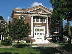
Plymouth Southside Historic District is a national historic district located at Plymouth, Marshall County, Indiana. The district encompasses 91 contributing buildings, 2 contributing structures, and 1 contributing object in a predominantly residential section of Plymouth. It developed between about 1853 and 1953, and includes examples of Italianate, Greek Revival, Queen Anne, Colonial Revival, and Tudor Revival style architecture. Notable contributing resources include the John McFarlin, Jr., House (c. 1860), Trinity United Methodist Church (1926), Bible Baptist Church (1894), Felke Florist and Greenhouse (1922), John Soice Residence (c. 1875), Westervelt-Marble Residence (c. 1865, 1899), and Edwards-Gambel Residence (1856).[2]
It was listed on the National Register of Historic Places in 2013.[1]
References
- 1 2 "National Register of Historic Places Listings". Weekly List of Actions Taken on Properties: 12/30/13 through 1/03/14. National Park Service. 2014-01-10.
- ↑ "Indiana State Historic Architectural and Archaeological Research Database (SHAARD)" (Searchable database). Department of Natural Resources, Division of Historic Preservation and Archaeology. Retrieved 2016-05-01. Note: This includes Kurt West Garner (June 2012). "National Register of Historic Places Inventory Nomination Form: Plymouth Southside Historic District" (PDF). Retrieved 2016-05-01., Site map, Quad map, and Accompanying photographs.

