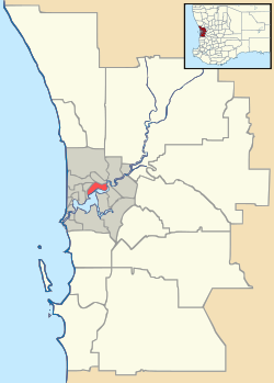
Pinjar, Western Australia
| Pinjar Perth, Western Australia | |||||||||||||
|---|---|---|---|---|---|---|---|---|---|---|---|---|---|
 Pinjar | |||||||||||||
| Coordinates | 31°37′26″S 115°49′52″E / 31.624°S 115.831°ECoordinates: 31°37′26″S 115°49′52″E / 31.624°S 115.831°E | ||||||||||||
| Postcode(s) | 6078 | ||||||||||||
| Area | 27.4 km2 (10.6 sq mi) | ||||||||||||
| Location | 40 km (25 mi) N of Perth CBD | ||||||||||||
| LGA(s) | City of Wanneroo | ||||||||||||
| State electorate(s) | Mindarie | ||||||||||||
| Federal Division(s) | Pearce | ||||||||||||
| |||||||||||||
Pinjar is a rural locality in Perth, Western Australia. Its local government area is the City of Wanneroo.
History
The suburb of Pinjar is named after the large swampy lake of this name located north east of Wanneroo. The lake name is shown on government plans from 1868, and the name is of Noongar Aboriginal origin. The meaning of Pinjar is unknown, but could be "tadpole" or "swampy lake".[1]
Geography
Pinjar is bounded by Pinjar Road/Old Yanchep Road to the west and Neaves Road to the south. Its northern and eastern boundaries are not gazetted.[2]
Facilities
Pinjar is a sparsely populated agricultural suburb, most of which is pine plantation and wetland. At the ABS 2006 census, Pinjar had a population of 78 people living in 39 dwellings.[3] It was not measured in 2011.
References
- ↑ Western Australian Land Information Authority. "History of metropolitan suburb names – P". Retrieved 2007-01-17.
- ↑ 2007 StreetSmart directory, Department of Lands and Surveys, Perth, with info from Battye Library.
- ↑ Australian Bureau of Statistics (25 October 2007). "Community Profile Series : Pinjar (State Suburb)". 2006 Census of Population and Housing. Retrieved 4 July 2012.
This article is issued from Wikipedia - version of the 3/2/2014. The text is available under the Creative Commons Attribution/Share Alike but additional terms may apply for the media files.
