Pinheiro, Maranhão
| Pinheiro | |
|---|---|
| Municipality | |
| The Municipality of Pinheiro | |
|
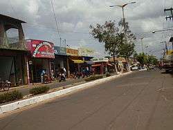
An avenue in Pinheiro | |
| Nickname(s): "Princesa da Baixada" (Princess of the Baixada[1]) | |
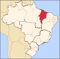
 Location of Pinheiro in the State of Maranhão | |
| Coordinates: 02°31′15″S 45°04′58″W / 2.52083°S 45.08278°WCoordinates: 02°31′15″S 45°04′58″W / 2.52083°S 45.08278°W | |
| Country | Brazil |
| Region | Northeast |
| State | Maranhão |
| Founded | September 3, 1856 |
| Government | |
| • Mayor | José Arlindo Silva Sousa (DEM) |
| Area | |
| • Total | 1,465.503 km2 (565.834 sq mi) |
| [2] | |
| Population (2012) | |
| • Total | 79,566 |
| • Density | 54/km2 (140/sq mi) |
| [3] | |
| Time zone | UTC-3 (UTC-3) |
| HDI (2000) | 0.639 – medium[4] |
| Website | www.pinheiro.ma.gov.br |
Pinheiro is a municipality in the state of Maranhão in the Northeast region of Brazil.
The municipality contains a small part of the Baixada Maranhense Environmental Protection Area, a 1,775,035.6 hectares (4,386,208 acres) sustainable use conservation unit created in 1991 that has been a Ramsar Site since 2000.[5]
See also
References
- ↑ "Baixada" is a Brazilian word for flat areas near the sea
- ↑ IBGE - "Archived copy". Archived from the original on January 9, 2007. Retrieved August 3, 2014.
- ↑ "2012 Populational Estimate" (PDF). Censo Populacional 2012. Instituto Brasileiro de Geografia e Estatística (IBGE). July 2012. Retrieved September 8, 2012.
- ↑ UNDP
- ↑ APA Baixada Maranhense (in Portuguese), ISA: Instituto Socioambiental, retrieved 2016-06-13
This article is issued from Wikipedia - version of the 9/14/2016. The text is available under the Creative Commons Attribution/Share Alike but additional terms may apply for the media files.