Maranhão
| State of Maranhão | |||
|---|---|---|---|
| State | |||
| |||
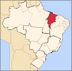
 Location of State of Maranhão in Brazil | |||
| Coordinates: 6°11′S 45°37′W / 6.183°S 45.617°WCoordinates: 6°11′S 45°37′W / 6.183°S 45.617°W | |||
| Country |
| ||
| Capital and Largest City | São Luís | ||
| Government | |||
| • Governor | Flávio Dino (PCdoB) | ||
| • Vice Governor | Carlos Orleans Brandão | ||
| Area | |||
| • Total | 331,983.293 km2 (128,179.466 sq mi) | ||
| Area rank | 8th | ||
| Population (2012)[1] | |||
| • Total | 6,714,314 | ||
| • Rank | 10th | ||
| • Density | 20/km2 (52/sq mi) | ||
| • Density rank | 16th | ||
| Demonym(s) | Maranhense | ||
| GDP | |||
| • Year | 2006 estimate | ||
| • Total | R$ 28,621,000,000 (16th) | ||
| • Per capita | R$ 4,628 (26th) | ||
| HDI | |||
| • Year | 2010 | ||
| • Category | 0.639 – medium (26th) | ||
| Time zone | BRT (UTC-3) | ||
| • Summer (DST) | BRST (UTC-2) | ||
| Postal Code | 65000-000 to 65990-000 | ||
| ISO 3166 code | BR-MA | ||
| Website | ma.gov.br | ||


Maranhão (Portuguese pronunciation: [mɐɾɐˈɲɐ̃w]) is a northeastern state of Brazil. To the north lies the Atlantic Ocean. Maranhão is neighboured by the (clockwise from east) states of Piauí, Tocantins and Pará. The people of Maranhão have a distinctive accent inside the common Northeastern Brazilian dialect. Maranhão is described in books such as The Land of the Palm Trees by Gonçalves Dias and Casa de Pensão by Aluísio Azevedo.
The dunes of Lençóis are an important area of environmental preservation. Also of interest is the state capital of São Luís, designated a Unesco World Heritage Site. Another important conservation area is the Parnaíba River delta, between the states of Maranhão and Piauí, with its lagoons, desert dunes and deserted beaches or islands, such as the Caju island, which shelters rare birds.
Geography


The northern portion of the state is a heavily forested plain traversed by numerous rivers, occupied by the eastern extension of the tropical moist forests of Amazonia. The Tocantins-Araguaia-Maranhão moist forests occupy the northwestern portion of the state, extending from the Pindaré River west into neighboring Pará state. The north-central and northeastern portion of the state, extending eastward into northern Piauí, is home to the Maranhão Babaçu forests, a degraded tropical moist forest ecoregion dominated by the Babaçu palm. Much of the forest has been cleared for cattle grazing and agriculture, and the Babaçu palm produces edible oil which is extracted commercially.
The southern portion of the state belong to the lower terraces of the great Brazilian Highlands, occupied by the Cerrado savannas. Several plateau escarpments, including the Chapada das Mangabeiras, Serra do Tiracambu, and Serra das Alpercatas, mark the state's northern margin and the outlines of river valleys.
The climate is hot, and the year is divided into a wet and dry season, extreme humidity being characteristic of the former. The heat, however, is greatly modified on the coast by the south-east trade winds.
The rivers of the state all flow northward to the Atlantic and a majority of them have navigable channels. The Gurupi River forms the northwestern boundary of the state, separating Maranhão from neighboring Pará, and the Tocantins River forms part the state's southwestern boundary with Tocantins state. The Parnaíba River forms the eastern boundary of Maranhão, but it has one large tributary, the Balsas, entirely within the state. Other rivers in the state include the Turiassu (or Turiaçu) which runs just east of the Gurupi, emptying into the Baía de Turiassu; the Mearim, Pindaré, and Grajaú, which empty into the Baía de São Marcos; and the Itapecuru and Munim which discharge into the Baía de São José. Like the Amazon, the Mearim has a pororoca or tidal bore in its lower channel, which greatly interferes with navigation.
The western coastline has many small indentations, which are usually masked by islands or shoals. The largest of these are the Baía de Turiassu, facing which is São João Island, and the contiguous bays of São Marcos and São José, between which is the large island of São Luís. This indented shoreline is home to the Maranhão mangroves, the tallest mangrove forests in the world. The coastline east of Baía de São José is less indented and characterized by sand dunes, including the stark dune fields of the Lençóis Maranhenses National Park, as well as restinga forests that form on stabilized dunes.
History
The first known European to explore Maranhão was the Spanish explorer Vicente Yáñez Pinzón in 1500, but it was granted to João de Barros in 1534 as a Portuguese hereditary captaincy. The first European settlement, however, was made by a French trading expedition under Jacques Riffault, of Dieppe, in 1594, who lost two of his three vessels in the vicinity of São Luís Island, and left a part of his men on that island when he returned home. Subsequently, Daniel de La Touche, Seigneur de La Rividière was sent to report on the place, and was then commissioned by the French crown to found a colony on the island; this was done in 1612. The French were expelled by the Portuguese in 1615, and the Dutch held the island from 1641 to 1644. In 1621 Ceará, Maranhão and Pará were united and called the "Estado do Maranhao," which was separated from the southern captaincies. Very successful Indian missions were soon begun by the Jesuits, who were temporarily expelled as a result of a civil war in 1684 for their opposition to the enslavement of the Indians. Ceará was subsequently detached, but the State of Maranhão remained separate until 1774, when it again became subject to the colonial administration of Brazil.
In the late 18th century, there was a great influx of enslaved peoples into the region, which corresponded to the increased cultivation of cotton. According to the historian Sven Beckert, the region's cotton exports "doubled between 1770 and 1780, nearly doubled again by 1790, and nearly tripled once more by 1800."[2]

Maranhão did not join in the Brazilian declaration of independence of 1822, but in the following year the Portuguese were driven out by British sailor and liberator Admiral Lord Cochrane and it became part of the Empire of Brazil. For this achievement Lord Cochrane became 1st Marques of Maranhão and Governor of Maranhão Province.
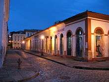
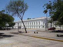
São Luís is the Brazilian state capital which most closely resembles a Portuguese city. By the early 20th century São Luís has about 30,000 inhabitants, and contained several convents, charitable institutes, the episcopal palace, a fine Carmelite church, and an ecclesiastical seminary. The historic city center was declared a World Heritage Site in 1997.São Luís, Maranhão
Demographics
According to the IBGE of 2008, there were 6,400,000 people residing in the state. The population density was 18.6 inh./km².
Urbanization: 68.1% (2004); Population growth: 1.5% (1991–2000); Houses: 1,442,500 (2005).[4]
The last PNAD (National Research for Sample of Domiciles) census revealed the following numbers: 4,271,000 Brown (Multiracial) people (66.74%), 1,636,000 White people (25.57%), 410,000 Black people (6.41%), 43,000 Asian people (0.67%), 39,000 Amerindian people (0.60%).[5]
Largest cities
| Largest cities or towns in Maranhão (2011 census of Instituto Brasileiro de Geografia e Estatística)[6] | |||||||||
|---|---|---|---|---|---|---|---|---|---|
| Rank | Microregion | Pop. | Rank | Microregion | Pop. | ||||
 São Luís  Imperatriz |
1 | São Luís | São Luís | 1027429 | 11 | Balsas | Gerais de Balsas | 85321 | |
| 2 | Imperatriz | Imperatriz | 248805 | 12 | Barra do Corda | Alto Mearim e Grajaú | 83582 | ||
| 3 | Timon | Caxias | 156327 | 13 | Pinheiro | Baixada Maranhense | 78875 | ||
| 4 | Caxias | Caxias | 156327 | 14 | Santa Luzia | Pindaré | 74500 | ||
| 5 | São José de Ribamar | São Luís | 165418 | 15 | Chapadinha | Chapadinha | 74273 | ||
| 6 | Codó | Codó | 118567 | 16 | Buriticupu | Pindaré | 66325 | ||
| 7 | Paço do Lumiar | São Luís | 107764 | 17 | Coroatá | Microrregião de Codó | 62189 | ||
| 8 | Açailândia | Imperatriz | 105254 | 18 | Itapecuru-Mirim | Itapecuru-Mirim | 63023 | ||
| 9 | Bacabal | Médio Mearim | 100614 | 19 | Grajaú | Alto Mearim e Grajaú | 63203 | ||
| 10 | Santa Inês | Pindaré | 78020 | 20 | Barreirinhas | Lençois Maranhenses | 56123 | ||
Economy
.jpg)
Maranhão is one of the poorest states of Brazil.[7] The service sector is the largest component of GDP at 54.5%, followed by the industrial sector at 25.4%. Agriculture represents 20.1%, of GDP (2004). Maranhão exports: aluminium 50%, iron 23.7%, soybean 13.1% (2002).
Share of the Brazilian economy: 0.9% (2004).[8]
Maranhão is also known as the land of the palm trees, as the various species of this tree provide its major source of income. The most important of them, from an economic point of view, is the babassu. The agribusiness, the aluminium and alumina transformation industries, and the food and timber industries complement the state economy.
Education
Portuguese is the official national language, and thus the primary language taught in schools. But English and Spanish are part of the official high school curriculum.
Educational institutions
Educational institutions in Maranhão include:
- Universidade Federal do Maranhão (UFMA) (Federal University of Maranhão)
- Universidade Estadual do Maranhão (UEMA) (State University of Maranhão)
- Centro Universitário do Maranhão (UNICEUMA) (University Center of Maranhão)
- Unidade de Ensino Superior do Sul do Maranhão (UNISULMA)
- Unidade de Ensino Superior Dom Bosco (UNDB)
- Instituto Federal do Maranhão (IFMA)
Infrastructure
Airports
Marechal Cunha Machado International Airport is located 13 kilometres (8.1 mi) from the center of São Luís. It began handling international flights in October 2004. It has a covered area of 8,100 square metres (87,000 sq ft) and a capacity of one million passengers per year.
Renato Moreira Airport is a national airport located in Imperatriz. Infraero has administered the airport since November 3, 1980, one year before it was officially opened. The passenger terminal was modified and expanded in 1998, giving it new arrival and departure areas, an expanded main concourse, and air conditioning of the entire terminal.
Highways
BR-010 and BR-230.
Telecommunications
The telephone area codes (named DDD in Brazil) for Maranhão are 98 and 99.[9]
Flag
The flag of Maranhão was designed by the poet Joaquim de Souza Andrade, and was adopted by decree nr. 6, of December 21, 1889.
The colored strips symbolize the different ethnic groups which make up the population, and their mixing and living together. The white star in the upper left corner symbolizes Maranhão itself, and is supposed to be Beta Scorpii, as the constellation Scorpius is also depicted on the national flag of Brazil. The flag has a ratio of 2:3.
Portrayals in film
- Andrucha Waddington's The House of Sand (Casa de Areia, 2005) prominently features the sand dunes of Maranhão.
- Carla Camurati's Carlota Joaquina, Princess of Brazil (1995) was filmed in the historical center of São Luís, a UNESCO World Heritage Site.
- The song Kadhal Anukkal from Endhiran (Tamil, 2010) featuring Aishwarya Rai and Rajnikanth was filmed at the Lençóis Maranhenses National Park sand dunes.
Notes
- ↑
- ↑ Beckert, Sven (2014). Empire of Cotton: A Global History. New York: Knopf.
- ↑ The Scots Peerage: founded on Wood's ed. of Sir Robert Douglas's Peerage of Scotland; containing an historical and genealogical account of the nobility of that kingdom; p. 368; by Paul, James Balfour, Sir, 1846-1931; Edinburgh: D. Douglas; Not in copyright
- ↑ Source: PNAD.
- ↑ (PDF) (in Portuguese). Maranhão, Brazil: IBGE. 2008. ISBN 85-240-3919-1 http://www.sidra.ibge.gov.br/bda/tabela/listabl.asp?z=pnad&o=3&i=P&c=262. Retrieved 2010-01-18. Missing or empty
|title=(help) - ↑ "ESTIMATIVAS DA POPULAÇÃO RESIDENTE NOS MUNICÍPIOS BRASILEIROS COM DATA DE REFERÊNCIA EM 1º DE JULHO DE 2011" (PDF) (in Portuguese). Instituto Brasileiro de Geografia e Estatística. 30 August 2011. Archived from the original (PDF) on 31 August 2011. Retrieved 31 August 2011.
- ↑
- ↑ List of Brazilian states by GDP (PDF) (in Portuguese). Maranhão, Brazil: IBGE. 2004. ISBN 85-240-3919-1.
- ↑ "DDD do Maranhao". Retrieved August 12, 2016.
References
 This article incorporates text from a publication now in the public domain: Chisholm, Hugh, ed. (1911). "article name needed". Encyclopædia Britannica (11th ed.). Cambridge University Press.
- This article incorporates text from the Catholic Encyclopedia, a publication now in the public domain.
External links
- (Portuguese) Official website
- Relação Sumária das Cousas do Maranhão, by Simão Estácio da Silveira, a contemporary account of the early Portuguese colonization of Maranhão, published in Lisbon in 1624 by a leading coloniser
- History of the Commerce of Maranhão (1612 - 1895), by Jerônimo de Viveiros
- Revista do Instituto Histórico e Geográfico Brasileiro, 1909, Tomo LXXII - Parte I, Chronicle of the Jesuits in Maranhão, by João Felipe Bettendorf
- Historical geographical dictionary of Maranhão, by César Marques