Pennsylvania Route 706
| |||||||
|---|---|---|---|---|---|---|---|
 | |||||||
| Route information | |||||||
| Maintained by PennDOT | |||||||
| Length: | 36.1 mi[1] (58.1 km) | ||||||
| Existed: | March 14, 1972[2] – present | ||||||
| Major junctions | |||||||
| West end: |
| ||||||
|
| |||||||
| East end: |
| ||||||
| Location | |||||||
| Counties: | Bradford, Susquehanna | ||||||
| Highway system | |||||||
| |||||||

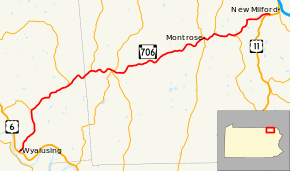
Pennsylvania Route 706 (PA 706) is a 36.1-mile-long (58.1 km) state highway in Pennsylvania. The western terminus is at U.S. Route 6 in Wyalusing, and the eastern terminus is at U.S. Route 11 in New Milford.
Route description
PA 706 begins at an intersection with US 6 in Wyalusing, Bradford County, heading northeast on two-lane undivided Church Street. The road passes downtown businesses before heading into residential areas, becoming Taylor Avenue. The route turns north into agricultural areas and crosses into Wyalusing Township, becoming an unnamed road and running to the west of Wyalusing Creek. PA 706 turns northeast and passes some industry, heading into more wooded areas with some fields and homes. The road crosses the creek and turns north at Merryall, running through more farmland with some woods and residences to the east of Wyalusing Creek. The route crosses the creek again and heads into the community of Camptown, turning to the northeast at an intersection with the northern terminus of PA 409. PA 706 runs through more agricultural and wooded areas with some homes to the northwest of Wyalusing Creek, crossing into Stevens Township. The road heads through more forested areas with some fields and residences, passing through Stevensville. The route intersects the eastern end of PA 467 and continues through more rural areas, winding to the east.[1][3]
PA 706 enters Rush Township in Susquehanna County and heads northeast through a mix of farmland and woodland with some residences, passing through Rushville and intersecting the southern terminus of PA 858. The road turns east and crosses the Wyalusing Creek, winding east through more rural areas to the south of the creek. The route comes to an intersection with PA 267, at which point that route turns east to form a concurrency with PA 706, crossing the East Branch Wyalusing Creek and turning southeast. PA 267 splits from PA 706 by turning northeast and PA 706 continues east through more forested areas with some fields and homes to the north of the East Branch Wyalusing Creek, turning northeast and passing through Rush. The road turns east and heads into Jessup Township, passing through more forests before continuing into a mix of farmland and woods with some homes. The route turns northeast at Snows Mill and continues through more rural areas, passing through Fairdale. PA 706 heads more to the east before turning back to the northeast and crossing into Bridgewater Township, winding northeast through more agricultural and wooded areas with occasional residences. The road becomes Wyalusing Street, entering Montrose and coming to an intersection with PA 167.[1][4]
At this point, PA 706 forms a concurrency with PA 167, heading into residential areas and curving southeast onto Church Street. The two routes come to an intersection with PA 29 in the commercial downtown of Montrose, with that route joining PA 167/PA 706. The road passes more homes, turning northeast and becoming Grow Avenue. The three routes head into commercial areas and crosses back into Bridgewater Township, becoming an unnamed road. PA 29 splits to the north and PA 167/PA 706 continue east through more developed areas, winding east through woodland with residential and commercial establishments. In Tiffany, PA 167 splits to the southeast and PA 706 heads through more farmland and homes, turning northeast and passing through Heart Lake. The road continues into more wooded areas with some fields and residences, curving north before turning east and heading into New Milford Township. The route curves to the northeast and heads into more forested areas, curving east. PA 706 turns southeast and passes over Norfolk Southern's Sunbury Line before ending at US 11.[1][4]
History
Parts of the route were once designated Legislative Route 14,[5] Pennsylvania Route 67, and U.S. Route 106[6][7] prior to 1972. On March 14, 1972, US 106 was decommissioned; the section of that route between Wyalusing and New Milford then became PA 706. Signs were changed by April of that year.[2][8]
Major intersections
| County | Location | mi[1] | km | Destinations | Notes |
|---|---|---|---|---|---|
| Bradford | Wyalusing | 0.0 | 0.0 | ||
| Wyalusing Township | 5.2 | 8.4 | Northern terminus of PA 409 | ||
| Stevens Township | 9.9 | 15.9 | Eastern terminus of PA 467 | ||
| Susquehanna | Rush Township | 13.3 | 21.4 | Southern terminus of PA 858 | |
| 15.8 | 25.4 | Western end of PA 267 concurrency | |||
| 16.2 | 26.1 | Eastern end of PA 267 concurrency | |||
| Montrose | 27.4 | 44.1 | Western end of PA 167 concurrency | ||
| 27.7 | 44.6 | Western end of PA 29 concurrency | |||
| 28.8 | 46.3 | Western end of PA 29 concurrency | |||
| Bridgewater Township | 31.0 | 49.9 | Eastern end of PA 167 concurrency | ||
| New Milford Township | 36.1 | 58.1 | |||
1.000 mi = 1.609 km; 1.000 km = 0.621 mi
| |||||
PA 706 Truck
Bradford County
| |
|---|---|
| Location: | Bradford County |
Pennsylvania Route 706 Truck in Bradford County is a truck route that bypasses a weight-restricted bridge on PA 706 over Cold Creek on which trucks over 32 tons and combination loads over 40 tons are prohibited. It was signed in 2013.
Susquehanna County
| |
|---|---|
| Location: | Susquehanna County |
Pennsylvania Route 706 Truck in Susquehanna County is a truck route that bypasses a weight-restricted bridge on PA 706 over Pettis Creek on which trucks over 31 tons and combination loads over 40 tons are prohibited. It was signed in 2013.
See also
 U.S. Roads portal
 Pennsylvania portal
References
- 1 2 3 4 5 Google (December 19, 2011). "overview of Pennsylvania Route 706" (Map). Google Maps. Google. Retrieved December 19, 2011.
- 1 2 "Routes 611, 106 Will Be Changed". Standard-Speaker. Hazleton, PA. March 15, 1972. Retrieved August 13, 2015 – via Newspapers.com.

- ↑ Bradford County, Pennsylvania Highway Map (PDF) (Map). PennDOT. 2011. Retrieved December 16, 2011.
- 1 2 Susquehanna County, Pennsylvania Highway Map (PDF) (Map). PennDOT. 2011. Retrieved December 7, 2011.
- ↑ Map of the Public Roads in Bradford County, Pennsylvania (PDF) (Map). Department of Highways. October 1930. Retrieved June 1, 2013.
- ↑ General Highway Map - Bradford County, Pennsylvania (PDF) (Map). Pennsylvania Department of Highways. 1964. Retrieved June 1, 2013.
- ↑ General Highway Map - Susquehanna County, Pennsylvania (PDF) (Map). Pennsylvania Department of Transportation. 1969. Retrieved June 1, 2013.
- ↑ Pennsylvania State Highway Map (Map). Pennsylvania Department of Transportation. 1972–1973.