Pennsylvania Route 858
| ||||
|---|---|---|---|---|
 | ||||
| Route information | ||||
| Maintained by PennDOT | ||||
| Length: | 16.465 mi[1] (26.498 km) | |||
| Existed: | 1928 – present | |||
| Major junctions | ||||
| South end: |
| |||
| North end: |
| |||
| Location | ||||
| Counties: | Susquehanna | |||
| Highway system | ||||
| ||||

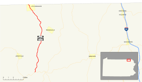
Pennsylvania Route 858 (designated by the Pennsylvania Department of Transportation as SR 0858) is a 16.465-mile-long (26.498 km) state highway located in Susquehanna County in Pennsylvania. The southern terminus is at PA 706 in Rush Township. The northern terminus is the New York state line in Little Meadows. The route from there continues as Tioga County Route 41. The route was assigned in 1928, completed a year later, and has remained the same since, with an exception of its southern terminus changing designations from Pennsylvania Route 67.
Route description
PA 858 begins at an intersection with PA 706 in the Rush Township community of Rushville. The highway begins its long trek in Susquehanna County by progressing northward in a patch of forests. PA 858, which runs west of a creek, is sparsely populated and homes are rare. PA 858 winds its way in and out of forests, heading on a northeast direction. Soon after, there is an intersection with Keefs Hill Road, a locally maintained highway. After Keefs Hill Road, PA 858 heads back into a dense patch of trees. In the forest, is an intersection with C. Warner Road, and soon after comes one for Shadduck Road.[2]
Although the dense forest ends, trees continue to surround the highway. The route turns a short drift off its alignment at an intersection with Miller Road. The route turns from the northward direction it was heading to a northwestern direction and intersects eventually with Guilton Road. The dense forestry returns, and Route 858 begins winding its way along. Residential homes have all but disappeared from the route, with trees showing the way into Middletown Center. PA 858 passes a pond to the east, intersecting with the former alignment of PA 859, now a locally maintained highway known as Vet Davis Road and Camp Corby Road.[2]
After leaving Middletown Center, PA 858 continues northward and sometimes northeastward. After Middletown Center, PA 858 is surrounded by nothing but trees. There is a break in the trees when PA 858 intersects with an unnamed road, which serves as a connector to Township Road 768. The state traffic route continues to the northwest, intersecting with Township Road 687. As PA 858 continues, it enters Apolacon Township, where the dense forestry begins to break, and homes begin to show the way. After a short pond is passed, the highway enters Little Meadows. At Maple Avenue, PA 858 runs on its final stretch, passing homes all the way to the New York state line. There, PA 858 ends and becomes County Route 41 upon entering Tioga County, New York.[2]
History

PA 858 was first assigned in the mass numbering of state traffic routes in Pennsylvania in 1928.[3] However, the southern terminus of the highway was not an intersection with Pennsylvania Route 706. Instead, it was an intersection with PA 67.[4] When it was assigned, it only ran from U.S. Route 106 to Town House Road, since the rest had not been completed yet.[4] The final, already paved segment of SR 858 was completed by the next year.[5] In 1932, the route south of Town House Road was paved.[6] In 1972, PA 67 was decommissioned, and the route at the southern terminus became PA 706.[7]
Major intersections
The entire route is in Susquehanna County. [8]
| Location[8] | mi[1] | km | Destinations | Notes | |
|---|---|---|---|---|---|
| Rush Township | 0.000 | 0.000 | |||
| Little Meadows | 16.465 | 26.498 | Continuation into Tioga County, New York | ||
| 1.000 mi = 1.609 km; 1.000 km = 0.621 mi | |||||
See also
 U.S. Roads portal
 Pennsylvania portal
References
- 1 2 Bureau of Maintenance and Operations (January 2015). Roadway Management System Straight Line Diagrams (Report) (2015 ed.). Pennsylvania Department of Transportation. Retrieved June 30, 2015.
- Susquehanna County (PDF)
- 1 2 3 Google (November 12, 2015). "Overview map of PA 858" (Map). Google Maps. Google. Retrieved November 12, 2015.
- ↑ Map Showing Pennsylvania State Highways (Map). Pennsylvania Department of Highways. 1927.
- 1 2 Map Showing Pennsylvania State Highways (Map). Pennsylvania Department of Highways. 1928.
- ↑ Tourist Map of Pennsylvania State Highways (Map). Pennsylvania Department of Highways. 1929.
- ↑ Tourist Map of Pennsylvania State Highways (Map). Pennsylvania Department of Highways. 1932.
- ↑ Pennsylvania State Highway Map (Map). Pennsylvania Department of Transportation. 1972–1973.
- 1 2 "Video Log". Pennsylvania Department of Transportation. Retrieved June 8, 2016.
External links
| Wikimedia Commons has media related to Pennsylvania Route 858. |