Paynesville, West Virginia
| Paynesville | |
|---|---|
| Unincorporated community | |
 Paynesville  Paynesville Location within the state of West Virginia | |
| Coordinates: 37°19′53″N 81°53′29″W / 37.33139°N 81.89139°WCoordinates: 37°19′53″N 81°53′29″W / 37.33139°N 81.89139°W | |
| Country | United States |
| State | West Virginia |
| County | McDowell |
| Elevation | 2,346 ft (715 m) |
| Time zone | Eastern (EST) (UTC-5) |
| • Summer (DST) | EDT (UTC-4) |
| ZIP code | 24873 |
| Area code(s) | 304 & 681 |
| GNIS feature ID | 1549869[1] |
Paynesville is an unincorporated community in McDowell County, West Virginia, United States. Paynesville is located along West Virginia Route 83 at the Virginia border. Paynesville has a post office with ZIP code 24873.[2]
Climate
The climate in this area is characterized by hot, humid summers and generally mild to cool winters. According to the Köppen Climate Classification system, Paynesville has a humid subtropical climate, abbreviated "Cfa" on climate maps.[3]
References
- ↑ "US Board on Geographic Names". United States Geological Survey. 2007-10-25. Retrieved 2008-01-31.
- ↑ ZIP Code Lookup
- ↑ Climate Summary for Paynesville, West Virginia
Municipalities and communities of McDowell County, West Virginia, United States | ||
|---|---|---|
| Cities | 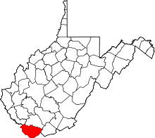 | |
| Towns | ||
| CDPs | ||
| Unincorporated communities |
| |
| Ghost town | ||
| Footnotes | ‡This populated place also has portions in an adjacent county or counties | |
This article is issued from Wikipedia - version of the 7/28/2016. The text is available under the Creative Commons Attribution/Share Alike but additional terms may apply for the media files.