Pageton, West Virginia
| Pageton | |
|---|---|
| Census-designated place (CDP) | |
 Pageton Location within the state of West Virginia | |
| Coordinates: 37°20′57″N 81°27′55″W / 37.34917°N 81.46528°WCoordinates: 37°20′57″N 81°27′55″W / 37.34917°N 81.46528°W | |
| Country | United States |
| State | West Virginia |
| County | McDowell |
| Area[1] | |
| • Total | 1.225 sq mi (3.17 km2) |
| • Land | 1.201 sq mi (3.11 km2) |
| • Water | 0.024 sq mi (0.06 km2) |
| Population (2010)[2] | |
| • Total | 187 |
| • Density | 150/sq mi (59/km2) |
| Time zone | Eastern (EST) (UTC-5) |
| • Summer (DST) | EDT (UTC-4) |
| ZIP codes | 24871 |
Pageton is a census-designated place (CDP) in McDowell County, West Virginia. As of the 2010 census, its population was 187.[2] Pageton is located on the Tug Fork Branch of the Norfolk and Western Railway, along the Pocahontas seam of rich bituminous coal. Pageton is located on State Route 161 between Thorpe and Anawalt.
History
Pageton was named after Louis R. Page, a colliery official.[3]
Legacy
Although coal mining activity ended long ago, the Page Coal and Coke Company Store at Pageton survives, and is listed on the National Register of Historic Places.[4]
References
- ↑ "US Gazetteer files: 2010, 2000, and 1990". United States Census Bureau. 2011-02-12. Retrieved 2011-04-23.
- 1 2 "American FactFinder". United States Census Bureau. Retrieved 2011-05-14.
- ↑ Kenny, Hamill (1945). West Virginia Place Names: Their Origin and Meaning, Including the Nomenclature of the Streams and Mountains. Piedmont, WV: The Place Name Press. p. 468.
- ↑ National Park Service (2010-07-09). "National Register Information System". National Register of Historic Places. National Park Service.
External links
- Virginian Railway (VGN) Enthusiasts non-profit group of preservationists, authors, photographers, historians, modelers, and railfans
- listing of Virginian Railway authors and their works
Municipalities and communities of McDowell County, West Virginia, United States | ||
|---|---|---|
| Cities | 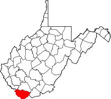 | |
| Towns | ||
| CDPs | ||
| Unincorporated communities |
| |
| Ghost town | ||
| Footnotes | ‡This populated place also has portions in an adjacent county or counties | |
This article is issued from Wikipedia - version of the 5/26/2016. The text is available under the Creative Commons Attribution/Share Alike but additional terms may apply for the media files.